 Portuguese
  English
  Spanish
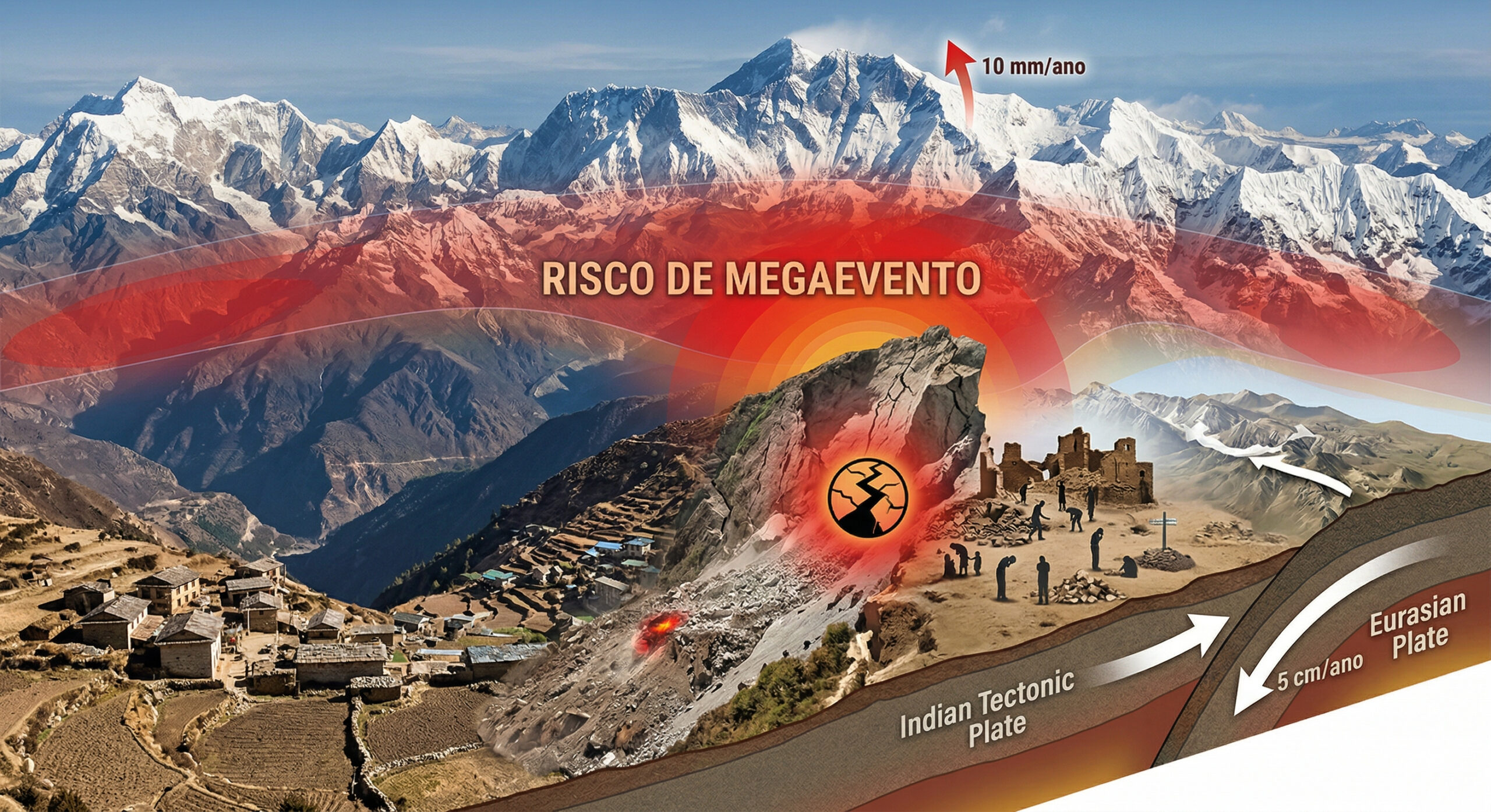
Himalayas continue to grow with tectonic plate collision, annual elevation, devastating earthquakes, and risk of mega seismic event
Over the past few decades, studies conducted by institutions such as the USGS, National Geographic, and research published in journals like Nature have shown that the Himalayas are not a static formation. The highest mountain range on the planet continues to grow today due to the collision between the Indian tectonic plate and the Eurasian plate, which began about 50 million years ago.
Data obtained from GPS, satellite interferometric radar (InSAR), and geodetic measurements indicate that India is moving northward at about 4.5 centimeters per year, while part of this movement is converted into vertical elevation, causing the mountains to rise between 5 and 10 millimeters annually. This continuous process transforms the Himalayas into one of the most geologically active regions on the planet.
Formation of the Himalayas: the 6 thousand kilometer journey of the Indian plate
We think of mountains as static structures, ancient formations that have always been there. The Himalayas contradict this intuition every second. The highest mountain range on Earth is being pushed upward right now by the collision between the Indian tectonic plate and the Eurasian plate, which began about 50 million years ago and has not stopped.
-
At an altitude of 400 km by astronauts from the International Space Station, Paris transforms at night into a golden mesh so precise that it reveals the outline of the Seine River, avenues, and entire neighborhoods like a luminous map drawn over the Earth.

-
iPhone 17 reaches historic low price with 256 GB, 120 Hz display, and drops to R$ 5,703 on Shopee, featuring A19 chip, dual 48 MP cameras, battery life of up to 30 hours, and advanced AI features.

-
Trip to Mars getting closer: Pulsar Fusion, from the UK, advances with plasma ignition in fusion engine and could drastically reduce space travel time, making crewed missions faster, safer, and economically viable.

-
Made with recycled plastic, a Lego-inspired brick builds a 180 m² house in 15 days, providing thermal comfort, preventing moisture, and turning waste into income, kits, and accelerated construction in the country.


About 225 million years ago, India was an isolated continental mass near present-day Australia, separated from Asia by the ancient Tethys Sea. With the fragmentation of the supercontinent Pangaea, which began about 200 million years ago, the Indian plate began to move northward, traveling more than 6 thousand kilometers over tens of millions of years.
When this continental mass collided with Eurasia, there was no complete subduction, as occurs in collisions with oceanic plates. Instead, the crust was compressed, deformed, and pushed upward, forming the Himalayan mountain range. This process created the largest relief structure on the planet in a relatively rapid geological scale.
Growth of the Himalayas: mountains rise up to 10 millimeters per year
The Himalayas extend approximately 2,900 kilometers along the border between India and Tibet. In about 50 million years, peaks like Everest have been raised to over 9 thousand meters in altitude.
Growth rates vary along the range. In regions like Nanga Parbat in the northwest, elevation can reach between 7 and 10 millimeters per year. On Everest, growth is more moderate, around 4 millimeters annually.
These measurements are confirmed by three independent methods: continuous GPS networks installed in Nepal, InSAR satellite data, and precision geodetic surveys in the field. The convergence of these methods proves that the growth of the Himalayas is real, continuous, and measurable.
Plate tectonics and earthquakes: the mechanism of the geological “elastic”
The tectonic dynamics of the Himalayas are often compared to an elastic band being stretched. As the Indian plate moves northward, tension accumulates along the main fault of the Himalayas, known as the Main Himalayan Thrust (MHT).

This fault represents the contact zone where the Indian plate partially dives beneath the Eurasian plate. The crust deforms elastically until the accumulated tension exceeds the resistance of the rocks, releasing energy abruptly.
The result is an earthquake. In seconds, the displacement occurs that should have accumulated over decades or centuries. This mechanism explains why tectonically active regions can remain stable for long periods and suddenly experience devastating events.
2015 earthquake in Nepal killed 9 thousand people and displaced Kathmandu in seconds
On April 25, 2015, at 11:56 AM, a magnitude 7.8 earthquake struck Nepal, with its epicenter in the Gorkha district, about 80 kilometers from Kathmandu. The rupture propagated for approximately 150 kilometers along the MHT fault.
The event killed nearly 9 thousand people, injured more than 22 thousand, and destroyed over 600 thousand homes. Historical structures in the Kathmandu valley were severely damaged, including complexes classified as World Heritage Sites.
GPS data showed that Kathmandu shifted about 1.2 meters to the south in a matter of seconds. The valley, formed by sediments from an ancient lake, amplified the seismic waves, intensifying the damage. The earthquake highlighted the magnitude of the tectonic forces still active in the region.
Avalanche on Everest was the deadliest in history after earthquake
The earthquake triggered a massive avalanche on Mount Everest, which hit the base camp and killed 22 people, marking the deadliest event ever recorded on the mountain.
Another large-scale landslide occurred in the Langtang valley, where about 250 people were reported missing. These events illustrate the concept of “risk cascade,” in which an earthquake triggers multiple secondary disasters.
In the Himalayas, the proximity between high altitudes and densely populated areas significantly amplifies the impacts of these events.
Study indicates risk of mega-earthquake after 2015 event
Research published in 2019 indicates that the 2015 earthquake may not have fully released the accumulated tension in the region. On the contrary, part of this energy may have been transferred to adjacent segments of the fault.

Studies point to the possibility of a future seismic event with a magnitude greater than 8.5. Analyses indicate that several segments of the Himalayan fault have enough accumulated energy to generate large-scale earthquakes.
This scenario puts hundreds of millions of people in areas of high seismic risk along the Indo-Gangetic plain.
Erosion and elevation maintain balance in the height of the Himalayas
Despite continuous growth, the mountains do not increase indefinitely due to the action of erosion. Wind, rain, ice, and gravity wear down the rocks, transporting sediments to rivers like the Ganges and Brahmaputra.
These sediments form the largest river delta on the planet, located in Bangladesh and eastern India. The interaction between tectonic elevation and erosion determines the final height of the mountains.
This dynamic balance prevents the Himalayas from growing indefinitely, even with the continuous pressure from tectonic plates.
Rivers of the Himalayas are older than the mountains they cross
An unintuitive geological aspect is that several rivers in the Himalayas are older than the mountains themselves. Rivers like the Kosi and Arun existed before the complete uplift of the range.
As the land rose, these rivers maintained their courses, carving deep gorges in the rock. An extreme example is the Kali Gandaki gorge, which is over 5,500 meters deep.
This phenomenon indicates that tectonic uplift was fast enough not to interrupt the existing river flow.
Himalayas influence the climate and sustain the Asian monsoons
The Himalayas act as a fundamental climatic barrier, blocking moist air masses coming from the Indian Ocean. This blockage forces the air to rise, cool, and precipitate, generating the monsoons that sustain agriculture in much of Asia.
Without this barrier, the Indian subcontinent would be significantly drier. The continuous elevation of the range directly influences regional climatic dynamics.
The interaction between geology and climate makes the Himalayas one of the most complex natural systems on the planet.
Tectonic pressure displaces Tibet and generates earthquakes in distant regions
The collision between the plates does not only affect the Himalayas. The resulting pressure pushes parts of the Tibetan plateau eastward, creating tensions that manifest in distant regions.
This effect is related to earthquakes in areas such as southwestern China, including the Sichuan event in 2008, which killed around 70 thousand people.
The redistribution of tectonic stresses demonstrates that the effects of the collision extend far beyond the Himalayan range.
The Himalayas are not a static monument, but a dynamic system in continuous evolution. The mountains continue to rise millimeter by millimeter, driven by the same force that initiated their formation millions of years ago.
At the same time, this force generates earthquakes, alters the relief, influences the climate, and redefines the geographical landscape of Asia. What seems permanent is, in reality, the result of active geological processes that continue to shape the planet to this day.


Seja o primeiro a reagir!