 Portuguese
  English
  Spanish
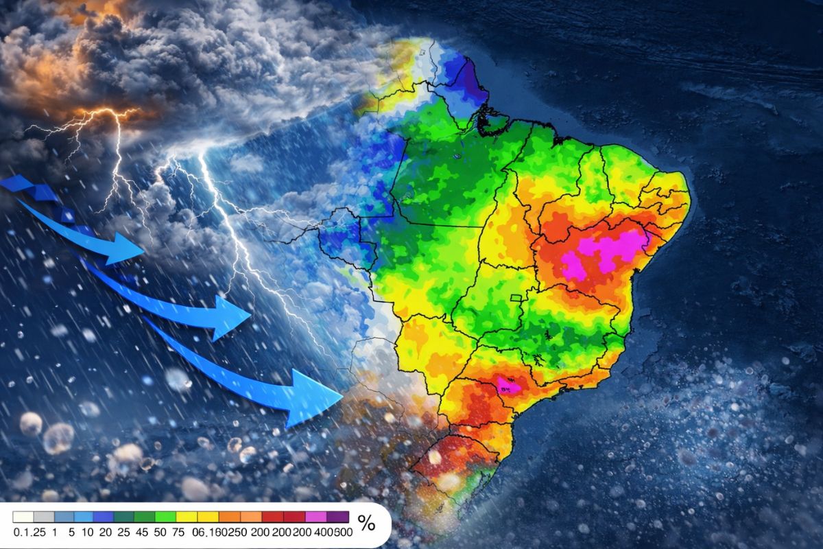
A new cold front is expected to change the weather in Brazil between Saturday night (11) and Sunday (12), putting Rio Grande do Sul, Santa Catarina, Paraná, Mato Grosso do Sul, and São Paulo in the path of severe storms with accumulations of up to 100 mm, hail, and wind gusts, according to the INMET.
A new cold front begins to reorganize the atmosphere over Brazil starting Saturday night (11) and puts five states on alert: Rio Grande do Sul, Santa Catarina, Paraná, Mato Grosso do Sul, and São Paulo. According to the National Institute of Meteorology (INMET), a low-pressure area is gaining strength over the South of the country and is expected to produce heavy showers, thunderstorms, wind gusts, and the possibility of hail throughout the weekend. Projections indicate accumulations of up to 100 millimeters in the most affected areas, enough to cause flooding, flash floods, and power outages.
The timing is particularly bad for those expecting a quiet weekend after the disruptions caused by the last cyclone. The new cold front arrives before many cities in the South have fully recovered, and the instability pattern predicted by INMET is clear: heavy clouds over the west and south-central regions of Rio Grande do Sul by Saturday night, advancing towards Santa Catarina and Paraná throughout Sunday. Mato Grosso do Sul and São Paulo will be on the edge of the system, with more localized but still significant showers.
How the new cold front forms and why it brings severe storms
The new cold front forms when a low-pressure area organizes the atmosphere and creates a meeting zone between the warmer air dominating the interior of Brazil and the colder air advancing from the south. It is from this collision that the conditions for intense rain, thunderstorms, and wind arise: the warm air rises rapidly, forming clouds with significant vertical development, and when the instability is strong enough, it produces hail. On the weather map, the system appears as a technical line; in real life, it manifests as a sudden change in the sky within hours.
-
Robots already operate oil rigs without humans, connect pipelines on their own, and inspect platforms in the dark, and the world’s largest drilling company plans to cut 75% of the crew at each well.

-
In China, a single person with artificial intelligence tools can already do the work of 50 to 100 employees: the new five-year plan bets on the one-person company model, and Suzhou is the laboratory for this revolution.

-
The USA accelerates the production of sensors launched into the ocean to hunt quieter submarines, and the new system promises to detect targets at greater distances in rough seas, shallow waters, and noisy areas, changing the game of anti-submarine warfare.

-
Science has discovered that white hair is not a sign of the body’s failure but rather a defense mechanism that sacrifices the color of the strands to protect the root against something much more serious.

In this episode, the new cold front begins to gain strength between the afternoon and evening of Saturday, first over the South of the country. Throughout Sunday, the system advances and spreads instability northward, reaching the south of Mato Grosso do Sul and the west of São Paulo. The key point for those living in these five states is to understand that the most intense core remains in the South Region, while the other two states receive the lateral effects of the new cold front, with localized showers that are still potentially dangerous.
Where the new cold front presents the greatest risk this weekend
The most concerning area is between the west of Rio Grande do Sul and the west of Santa Catarina by Saturday night. Cities like Uruguaiana and Chapecó enter a zone of greater sensitivity, with a real chance of organized severe storms, more intense winds, and hail. On Sunday, the rain spreads across the gaucho territory and reaches areas of Paraná, including parts of the west and southwest of the state.
This geographical distribution explains why the alert mentions five states, but the main focus of the new cold front remains in the South. In Mato Grosso do Sul and parts of São Paulo, the system is not expected to reproduce the same pattern of widespread and organized rain observed in Rio Grande do Sul and Santa Catarina. The most likely scenario for these two states is localized showers with isolated severe storms, especially during the afternoon of Sunday, affecting areas near Campo Grande, Ponta Porã, and Presidente Prudente.
How much rain is expected and what are the concrete risks
INMET’s projections indicate that the highest accumulations from the new cold front should concentrate between the west of Rio Grande do Sul, Santa Catarina, and part of Paraná, with volumes between 50 mm and 100 mm by the end of Sunday in the areas most favored by instability. The main issue is not just the total amount of rain, but the speed at which it can fall: when the accumulation occurs in a few hours, the risk of flooding, flash floods, power outages, and damage to fragile structures increases significantly.
The wind deserves special attention. In more organized severe storms, like those the new cold front is expected to produce in the South, gusts can cause rapid disruptions, especially in urban areas, with falling branches, signs, and metal structures. Hail is also not ruled out, a common occurrence when the atmosphere is very unstable and there are clouds with significant vertical development. Sunday may end with localized problems in parts of the South, and INMET’s recommendation is for residents in these regions to be extra cautious.
Is the new cold front going to bring intense cold this time?
Although the name suggests a drop in temperature, this new cold front is not expected to replicate the stronger cold sensation observed at the beginning of the week. The dominant effect of this episode tends to be more atmospheric instability than an intense polar mass. The highlight of the weekend is the rain, severe storms, and wind, not a broad and aggressive drop in temperatures in the south-central part of the country.
This distinction matters because many people automatically associate any new cold front with a cold wave. It doesn’t always work that way. Some fronts come more loaded with rain and wind, while the cold air that follows them is more modest. In this case, the weekend will be marked by changes in the sky, showers, and severe storms, without dramatic temperature drops in most of the five affected states. Those living in Rio Grande do Sul may feel some cooling after the passage of the new cold front, but nothing comparable to more intense polar episodes.
Recommendations for those living in the five affected states
INMET and the Civil Defense reinforce practical guidelines for those living in areas affected by the new cold front. Avoiding flooded streets and areas with flash floods is the most important rule, as most fatal accidents during severe storms occur when people try to cross flooded points on foot or by car. During wind gusts, do not seek shelter under trees or near signs and metal structures that could be blown away.
Other preventive measures include removing loose objects from yards, balconies, and patios before the arrival of the new cold front, unplugging appliances if there are thunderstorms, and being extra cautious with roofs and exposed vehicles in case of hail. In emergency situations, the Civil Defense numbers (199) and Fire Department (193) should be contacted immediately. Following updates on INMET’s alert page is the safest way to know if the intensity of the system has changed or if new states have been included in the risk area.
The new cold front arrives this weekend with severe storms of up to 100 mm, hail, and wind gusts in five states. Do you live in any of these regions? Have you felt the effects of the last cyclone? Tell us in the comments how the situation is in your city.


Seja o primeiro a reagir!