 Portuguese
  English
  Spanish
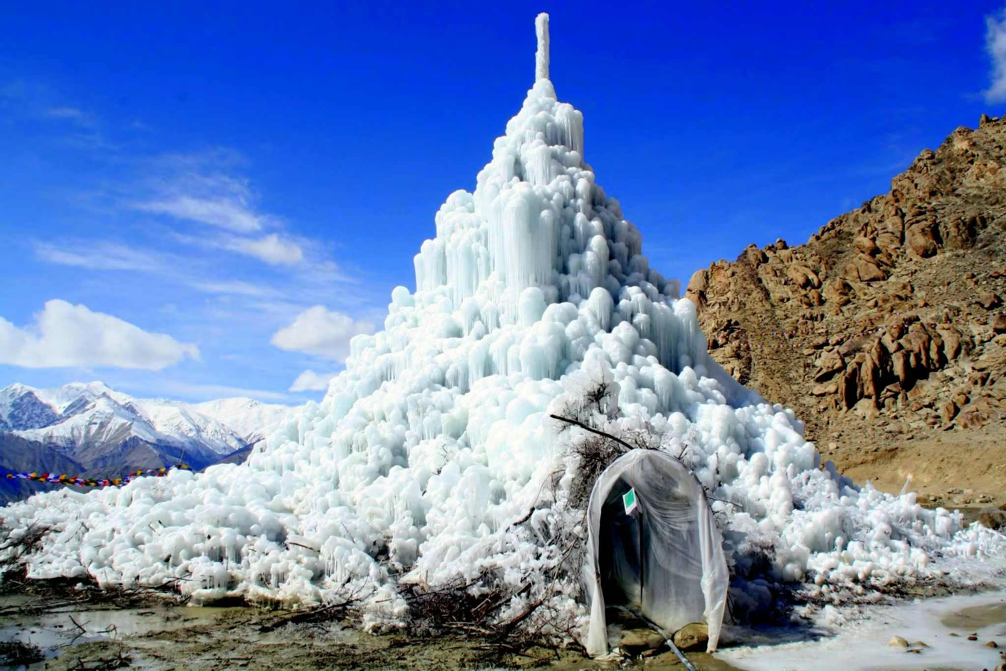
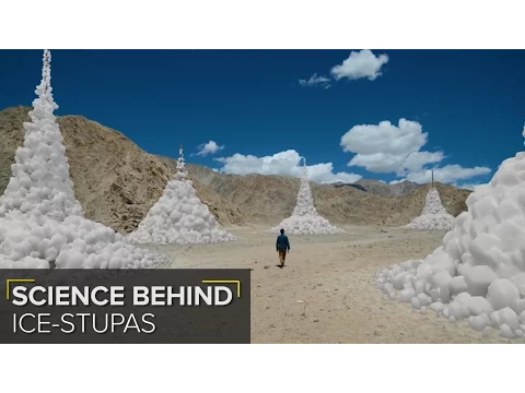
Artificial Glaciers of Up to 33 Meters and 7.5 Million Liters Ensure Irrigation in the Cold Desert of Ladakh and Become a Global Reference in Climate Adaptation.
The scenario that enabled the “artificial glaciers” is not a simple case of scarcity. Ladakh, in the far north of India, is over 3,000 meters in altitude, with an annual average precipitation lower than many sandy deserts, despite being surrounded by glacial mountain ranges. The paradox is evident: there is frozen water at the top of the mountains, but little liquid flow at the beginning of the agricultural season.
Ladakh’s subsistence agriculture, primarily based on naked barley, wheat, and vegetables, depends on early irrigation even in March and April, a period when the soil is thawing and the seeds need moisture to germinate. However, natural glaciers begin to release water only between May and June, when temperatures rise and ice melts on the slopes, feeding channels and rivers.
This temporal mismatch between water availability and agricultural demand has always been the main limiting factor for agricultural development in the region. Historically, part of the population solved this by storing snow, diverting small frozen streams, and building temporary dikes. But none of these solutions operated on a significant scale.
-
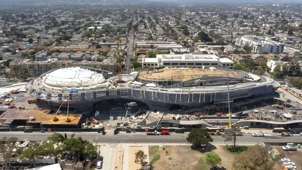
Created by George Lucas with over $1 billion, a futuristic museum in the shape of a spaceship with 1,500 curved panels is about to open in Los Angeles and will house one of the largest private collections of narrative art in the world.
-
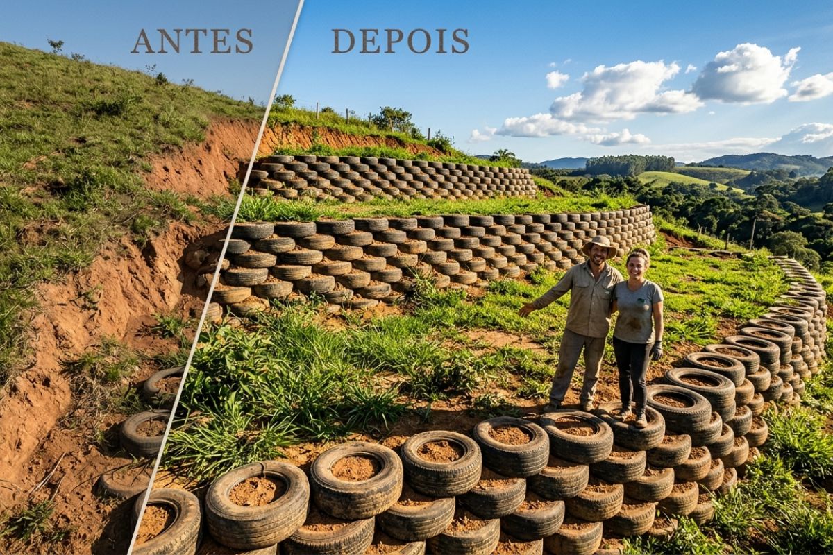
Couple shows how they built a retaining wall on their property using 400 old tires: sloped land turned into plateaus, tires are aligned, filled, and compacted with layers of soil, with grass helping in support and at almost zero cost.
-
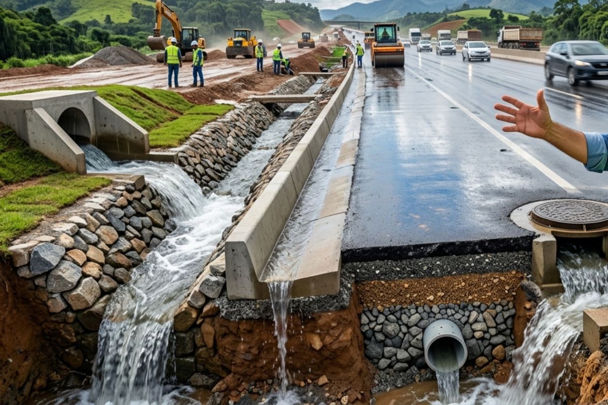
Engineer explains drainage during the rainy season: the difference between surface water and deep water, ditches, gutters, and water outlets on the road, as well as drains and drainage mattresses, to prevent erosion, aquaplaning, and flooding at the construction site today.
-
With 55 floors, 177 meters in height, a 15-meter walkway between the twin towers, ventilated facade, and 6,300 m² of leisure space, Ápice Towers already has one tower completed and another nearly at the top.


When climate change began to accelerate glacier melting and alter river seasonality, the problem ceased to be merely agricultural and became systemic: risk of rural exodus, dependence on imported food, and climate vulnerability in India’s border regions.
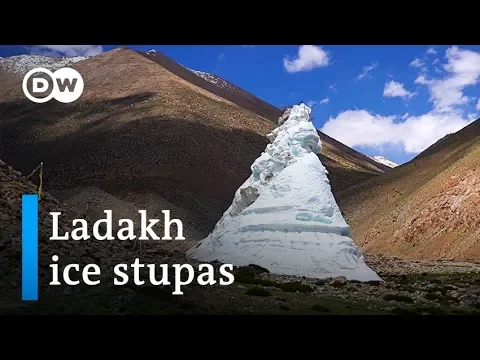
The Technical Proposal: Freeze Water in Winter, Release in Spring
The logic that led to the invention of the “Ice Stupas” was simple and elegantly physical: if the water does not arrive at the right time, it is necessary to change its phase to control the release time.
The process works like this:
- During the winter, water that would flow uselessly is diverted by gravity to villages.
- There are no pumps, as the system uses the height difference between the original channel and the exit point.
- The water is sprayed through perforated pipes, freezing instantly in the cold air.
- The frozen layers accumulate vertically, forming a tower of ice.
The conical shape is not aesthetic; it reduces the surface area exposed to the sun, slowing melting and ensuring slow release throughout spring. This transforms ice into hydraulic infrastructure and melted ice into scheduled irrigation.
Physical Dimensions and Water Volume: From the First Stupa to the Community Giants
The first experimental Ice Stupas were small, about 6 to 7 meters high with a capacity of several tens of thousands of liters. However, with geometric adjustments, increased base diameter, and higher water pressure in the pipes, the system scaled quickly.
Today there are Ice Stupas with the following documented dimensions:
- approximate maximum height: 33.5 meters
- estimated storage volume: up to 7.5 million liters
- natural lifespan: until the beginning of summer (May-June)
- agricultural capacity: irrigate entire hectares in March and April
The agricultural impact is not symbolic. In many villages, early irrigation ensures full annual production, while the absence of water in the initial phase nullifies planting.
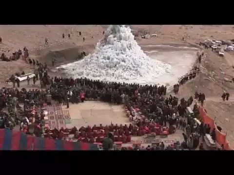
Who Idealized It and How the Technology Spread
The systematization of the method was carried out by engineer and educator Sonam Wangchuk, who viewed the problem from both a thermodynamic and social perspective. His observation was simple:
“There is no water shortage in Ladakh; it just arrives too late.”
Starting in 2014, villages began to learn the technique, technical schools in Leh began to replicate it, and local NGOs assisted in acquiring and distributing pipes, supports, and labor. The model, initially experimental, became a community project.
Today, the technology spreads in three directions:
- Horizontal Scale: more villages are adopting
- Vertical Scale: larger and more stable stupas
- International Scale: Nepal and Bhutan are studying replication
The Climatic Context: Why Ladakh Became a Resilience Laboratory
Ladakh is now one of the few places on the planet where one can observe the combined effect of:
- glacier retreat
- altered water seasonality
- annual thermal increment
- high-altitude desertification
- sensitive agricultural dependence
In this context, ice has become a form of seasonal hydraulic storage, similar to what hydropower plants do with reservoirs, but with low-cost material and no significant environmental impact.
Academic discussion already treats Ice Stupas as an indigenous climate adaptation technology, that is, a local solution adapted to social needs and geographical limitations.
How the Glaciers Melt and Irrigate the Land
Unlike reservoirs, stupas do not create water sheets, but capillary release. When the soil starts to warm, the base of the cone receives solar radiation, and the ice melts slowly towards the agricultural soil. It is a system of passive gravitational irrigation.
This gradual release guarantees:
- sufficient initial moisture for germination
- thermal cushioning of the soil
- water support before the natural glacier melt arrives
The cycle closes when the water from the mountains, which begins to melt in May, replaces the contributions from the stupas, ensuring water continuity.
Limitations, Risks, and Challenges for Scalability
Despite the enthusiasm, there are real technical limitations:
- dependence on extreme cold: the technique only works in regions with severe winters
- geographical restriction: requires altitude and low humidity
- scarcity of labor: construction is still artisanal and communal
- vulnerability to increasing heat: warmer summers may reduce lifespan
- need for hydraulic diversion: not all villages have nearby channels
The biggest future risk is the accelerated warming of the Himalayas, which could reduce both winter cold (freezing phase) and water from glaciers (replenishment phase).
The Geopolitical Dimension that Few Perceive
Ladakh is not just an agricultural territory; it is a strategic region for India, bordering China and Pakistan. Water vulnerability can cause:
- population depletion
- logistical dependence on other regions
- border socioeconomic fragility
By ensuring local supply, the stupas also play an indirect role in territorial resilience, although this is rarely discussed.
Why the World is Paying Attention to Ladakh
What makes the project globally relevant is the combination of:
- zero energy
- low cost
- use of gravity
- abundant material
- hydrological cycle synchronized with agriculture
- replicable community engineering
While large urban centers invest in desalination, pumping, and dams, Ladakh does the opposite: it uses ice as a dam, time as a valve, and mountain as a reservoir.
In the global debate on adaptation, few examples are as physically elegant and socially functional.


-

-

-

-

-

-

47 pessoas reagiram a isso.