 Portuguese
  English
  Spanish
Billion-Dollar Investment Foresees Permanent Connection Between Border Cities in Northern Brazil and Neighboring Country, with Direct Impact on Mobility, Cargo Transport, and Regional Integration, in Project That Includes Large-Scale Structure Over the Mamoré River and Associated Road Access.
The planned Binational Bridge to connect Guajará-Mirim, in Rondônia, to Guayaramerín, in Bolivia, has an estimated investment of R$ 421 million, a projected length of 1.22 kilometers, and a width of 17.3 meters, with a projected execution period of 36 months, according to information released by federal agencies related to transportation infrastructure.
The physical link between the two municipalities, separated by the Mamoré River, is presented by the Brazilian government as part of a series of projects aimed at border integration with neighboring countries.
Currently, the crossing occurs by means of vessels, a system that meets local demand but is subject to operational variations and river conditions.
-
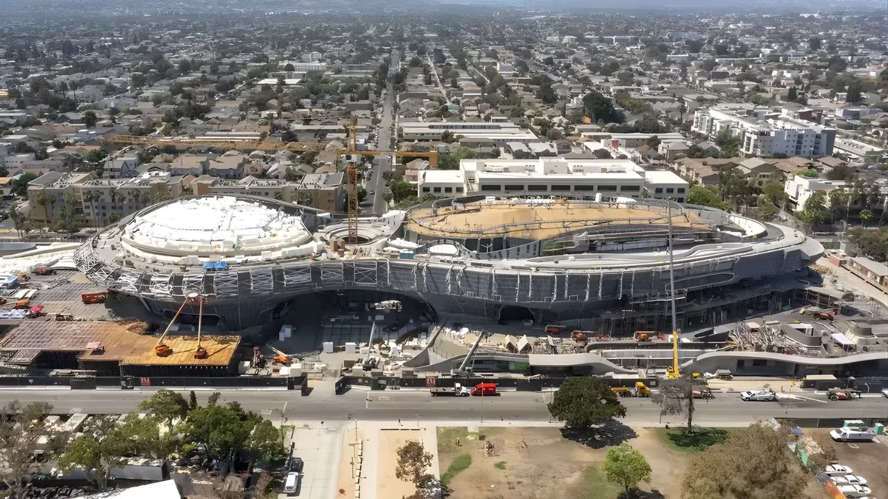
Created by George Lucas with over $1 billion, a futuristic museum in the shape of a spaceship with 1,500 curved panels is about to open in Los Angeles and will house one of the largest private collections of narrative art in the world.
-
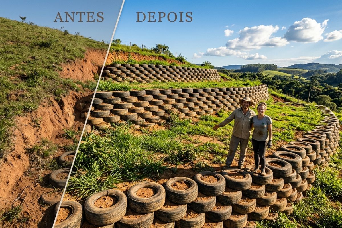
Couple shows how they built a retaining wall on their property using 400 old tires: sloped land turned into plateaus, tires are aligned, filled, and compacted with layers of soil, with grass helping in support and at almost zero cost.
-
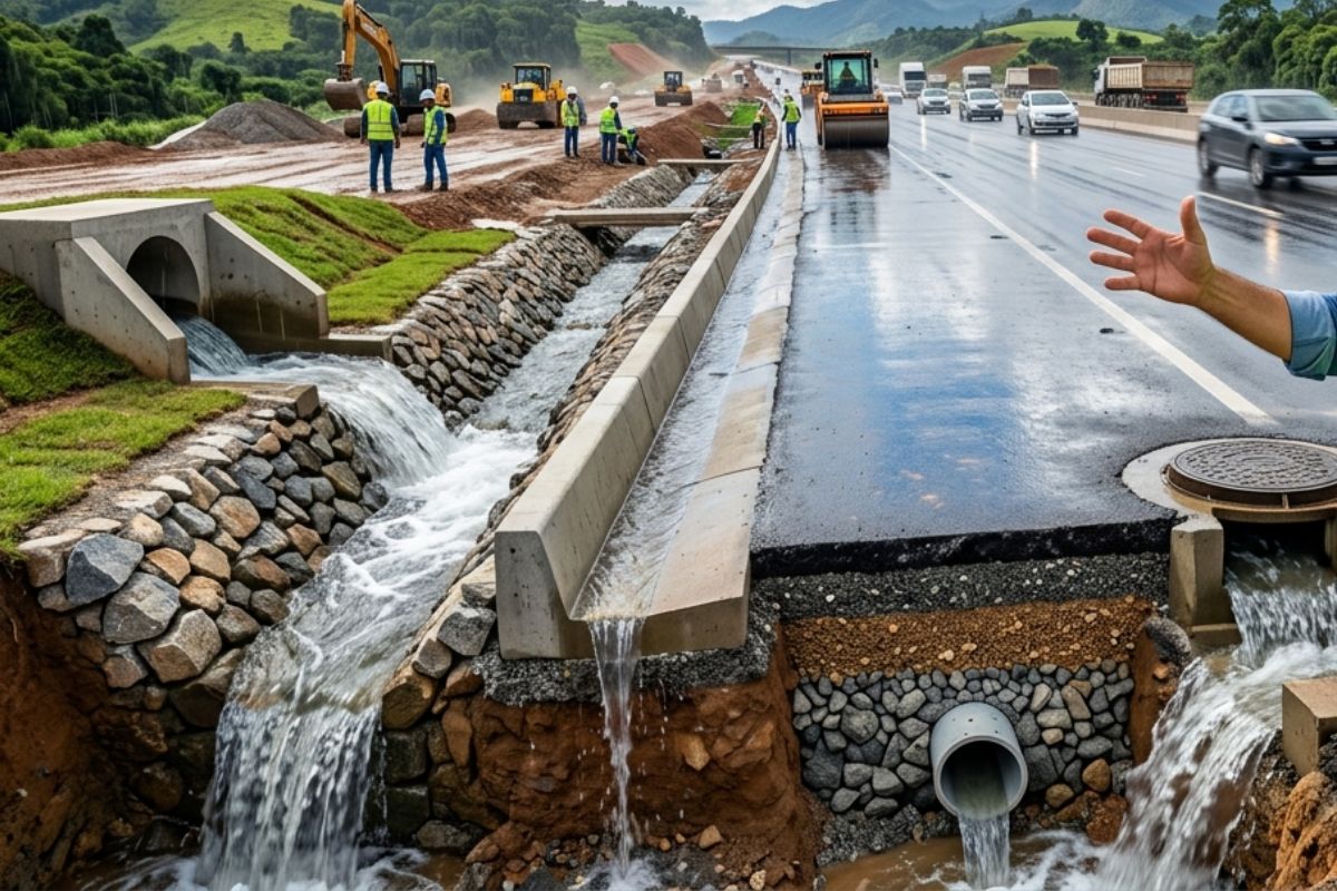
Engineer explains drainage during the rainy season: the difference between surface water and deep water, ditches, gutters, and water outlets on the road, as well as drains and drainage mattresses, to prevent erosion, aquaplaning, and flooding at the construction site today.
-
With 55 floors, 177 meters in height, a 15-meter walkway between the twin towers, ventilated facade, and 6,300 m² of leisure space, Ápice Towers already has one tower completed and another nearly at the top.


Binational Bridge Over the Mamoré River Integrates Federal Plan
The bridge is intended to cross the Mamoré River at the stretch that marks the border between Brazil and Bolivia, connecting the Brazilian side to the urban area of Guayaramerín.

The project is part of the New Growth Acceleration Program (PAC) and appears in official documents as a strategic work for regional logistics.
According to public communications from the National Department of Transport Infrastructure (DNIT), the project includes not only the main structure but also road accesses and complementary works necessary for connection with the existing road network.
The execution, however, depends on meeting contractual stages and the progress of the schedule after the formalization of the start of works.
In recent years, the project went through administrative processes, including bidding phases and analyses by control bodies.
Federal authorities informed that these stages have been gradually overcome, allowing the release of more detailed estimates regarding cost, dimensions, and timeline.
Changes in the Dynamics of Movement at the Border
The replacement of the river crossing with a permanent connection is indicated by public managers as a factor capable of changing the movement dynamics between Guajará-Mirim and Guayaramerín.
With the bridge, the circulation of people and goods tends to become less dependent on schedules and weather conditions, according to technical assessments disclosed in official notes.
Logistics and regional integration experts often emphasize that works of this kind can reduce uncertainties in short-distance transport, especially in border areas.

Still, the concrete effects on commerce, services, and mobility depend on additional factors, such as customs regulations, inspection capacity, and supporting infrastructure.
In Guajará-Mirim, local representatives see the work as an opportunity to enhance the municipality’s role in trade relations with Bolivia.
On the Bolivian side, the expectation mentioned by authorities is for improved access to services and regional exchange, although there are no official estimates on traffic volume or direct economic impact after completion.
Dimensions of the Work, Budget, and Timeline
According to data made public by the federal government, the bridge will be 1.22 kilometers long and 17.3 meters wide, dimensions compatible with large-scale road works in border areas.
The estimated amount of R$ 421 million refers to the entire project, including associated interventions.
The timeline of 36 months for execution is a technical projection based on the schedule presented in the initial documents.

In works of this nature, meeting the timeline is conditioned by factors such as land release, hydrological conditions, and the progress of work on the Bolivian side, which has its own responsibilities in integrating the connection.
The full operation of the bridge will also depend on the implementation of border control structures.
This definition involves binational agreements and administrative decisions that have not yet been publicly detailed.
Bolivia Houses the Largest Salt Flat on the Planet
Bolivia, the country that will have a direct land connection with Guajará-Mirim, is home to the Salar de Uyuni, recognized as the largest salt flat in the world.
Located in the southwest of Bolivia, the salt flat has an area estimated at around 10,582 km² and is approximately 3,656 meters above sea level, according to data widely cited in scientific and tourist publications.
Formed from the evaporation of ancient prehistoric lakes, the Salar de Uyuni stands out for its extensive and flat surface, covered by a crust of salt.
During the rainiest period, usually occurring between December and March, parts of the area may be covered by a thin layer of water.

This phenomenon creates the so-called “mirror effect,” widely documented in scientific and tourist records.
In addition to tourism, the salt flat appears in international debates related to natural resources.
These discussions, however, involve technical and economic aspects that do not directly relate to the bridge project at the northern border of Bolivia.
As the work on the Mamoré River progresses through administrative and technical stages, the physical connection between Guajará-Mirim and Guayaramerín continues to be presented as a potential milestone in regional integration.
This process remains conditioned by deadlines, complementary investments, and bilateral agreements.
What practical changes could this connection bring to the daily life of the border when the bridge is operational?


-

-

-

4 pessoas reagiram a isso.