 Portuguese
  English
  Spanish
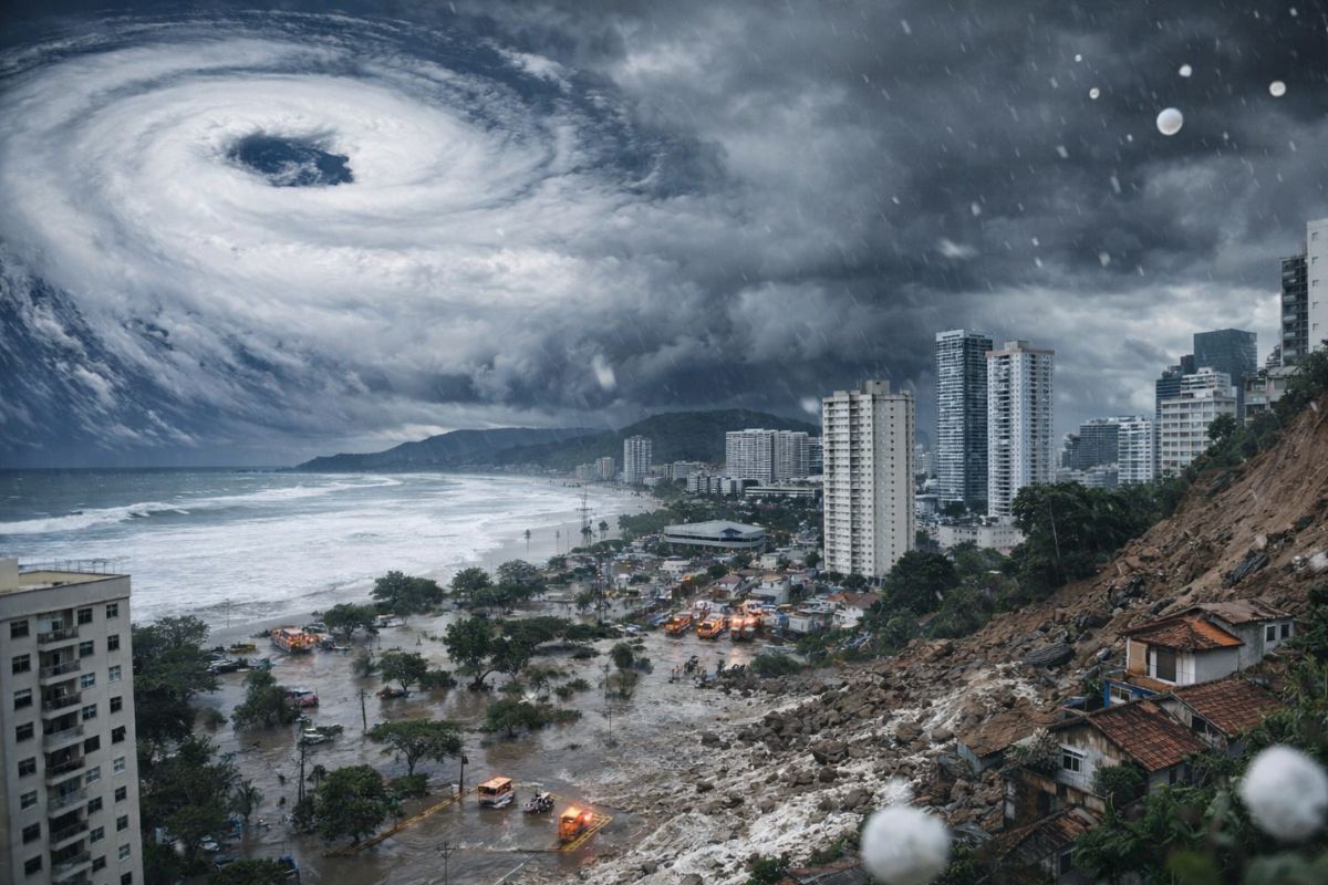
With the Prediction of Cyclone Formation on the Coast of SP, State Civil Defense and SEDS Gathered Municipalities This Thursday, the 29th, Aligned Contingency Plan, and Requested Teams on Standby for Friday, the 30th, When a Low-Pressure System May Bring High Accumulations, Flooding, Flash Floods, and Landslides in Regions of the State.
The Cyclone predicted for the coast of SP has put the State Civil Defense and the Department of Social Development into early response mode, with a task force coordinated with municipalities that may be affected by heavy rains and associated impacts.
In a meeting held this Thursday, the 29th, authorities aligned strategies to face the scenario of heavy rains expected from the night of the 29th and throughout the 30th, with increased risk of occurrences such as flooding, flash floods, and landslides.
Immediate Mobilization and Task Force with Municipalities
The formation of the Cyclone on the coast of SP prompted the activation of a task force involving potentially affected municipalities.
-
Surrounded by the sea, the airport will have a system to prevent airplanes from falling into the water; technology will be installed in Ilhéus (BA), with an investment of R$ 70 million.
-
With a cost per shot close to zero, the DragonFire laser could change naval warfare in 2027 and provide British ships with nearly unlimited defense against drones.

-
A British startup creates tires that generate electricity in electric vehicles when passing over potholes, speed bumps, and cracks.

-
Scientists have created robots made with living cells that have their own nervous system, swim on their own, explore the environment, and self-organize without any genetic engineering, and now they want to do the same with human cells.


The focus was on creating an operational contingency plan before the peak of instability, so that each city would already know how to act when the rains intensified.
The director of the State Civil Defense Response Division, Major Rodrigo Fiorentini, emphasized that early coordination is crucial for reducing impacts in situations like the Cyclone on the coast.
The mobilization of the State Civil Defense System was cited as the foundation for anticipating actions, aligning procedures, and enabling quick response.
What Meteorologists Indicate About the Cyclone
According to meteorologists at the Emergency Management Center, the operation of a low-pressure system on the coast of the state can cause high rainfall accumulations in different regions, increasing the risk of flooding, flash floods, and landslides.
This scenario is linked to the Cyclone expected for the coastal strip and tends to intensify during the period between the night of Thursday, the 29th and Friday, the 30th, precisely when municipal teams were instructed to maintain full readiness.
Teams on Standby and Materials Organized for Response
With the Cyclone on the radar, the State Civil Defense and SEDS requested that cities keep response teams on standby throughout Friday, the 30th. Additionally, municipalities were instructed to pre-organize necessary materials and equipment for response actions, avoiding delays when incidents start to multiply.
The logic is simple: at the height of an event associated with the Cyclone, the speed to activate teams, deploy resources, and start assistance can reduce damage and shorten the recovery time for the most affected areas.
Supplied Deposits and Items Ready for Immediate Withdrawal
The state government reported that state deposits are fully stocked with items that can be used for emergency support, with immediate withdrawal by municipalities and distribution to families affected by flooding or landslides.
Among the available items are mattresses, food baskets, blankets, pillows, sheets, cleaning supplies, and personal hygiene kits.
In a scenario of Cyclone with heavy rain and landslide risk, this supply structure is regarded as part of the plan to ensure a rapid response when there is a need for shelter and assistance.
Forecasted Risks and Areas Mentioned in the Cyclone Impact
According to information gathered by Agência Brasil, the operation of the Cyclone on the coast of SP may cause storms.
The cited risk includes a possibility of hail in much of the São Paulo state and also in neighboring municipalities of Minas Gerais, particularly in the Triângulo Mineiro.
Furthermore, localized storm forecasts were pointed out between the north of Santa Catarina, the east of Paraná, and the south of São Paulo, reinforcing that the effects of the Cyclone may reach areas beyond the São Paulo coast, depending on the dynamics of the atmospheric system.
Timeline of the Scenario: Thursday, Friday, Saturday, and Beginning of Next Week
The critical period begins on the night of Thursday, the 29th, and extends throughout Friday, the 30th, with the Cyclone associated with rain and the risk of occurrences such as flooding, flash floods, and landslides.
On Saturday, the 31st, rain is expected to concentrate between the Triângulo Mineiro and Rio de Janeiro. In this scope, accumulations may exceed 100 millimeters in 24 hours, which underscores the potential impact of a prolonged scenario linked to the Cyclone.
So far, forecasts indicate that the Cyclone is expected to continue acting until the beginning of next week, favoring the formation of a moisture channel between Espírito Santo and Mato Grosso, which may sustain the continuity of instability and rain.
Do you think your region is prepared for a Cyclone with the risk of hail, flooding, and landslides in the coming days?


-

-

5 pessoas reagiram a isso.