 Portuguese
  English
  Spanish
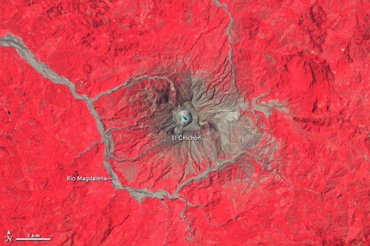
At The El Chichonal Volcano In The Mexican State Of Chiapas, The Crater Has Returned To Concentrate Measurements After Variations In Water Temperature, The Emergence Of Gases, And Sulfur Spheres. UNAM Recorded 118°C At The Bottom Of The Lake And Reinforced Monitoring Since June 2025, With Tourist Restrictions In A Regional Radius
The El Chichonal Volcano has once again been treated as a priority for scientific monitoring in Chiapas, Mexico, decades after the 1982 eruption. The current alert is not born from visible lava, but from discreet changes in the crater, with physico-chemical signs that reposition risk and access management.
The technical reading gained strength when measurements associated with UNAM pointed to out-of-pattern variations in the crater lake, involving extreme temperature at the bottom, new sulfur products, and intensification of gases. The sensitive point is that the transformation is silent, but operationally relevant, because it affects tourism, perimeters, and protocols.
What Changed In The Crater And Why Water Became An Indicator

The crater of the volcano has ceased to be merely a geographical marker and has begun to function as a panel of signals.
-
In Kenya, engineer Nzambi Matee created “bricks 2.0” using packaging plastic: a mixture with sand, heated and pressed; they are 5 times more resistant, already have official licensing, and are being used in streets and construction projects.
-
More than 20,000 positions could be opened, and thousands of technicians are starting to be trained in Brazil, as the expansion of data centers creates an urgent race for professionals to keep the internet, cloud, and artificial intelligence running 24 hours a day.

-
China approves the 15th Five-Year Plan 2026-2030 to become a global power: prioritizes brain implants, 6G with AI, humanoid robots, flying cars, quantum technology, and nuclear fusion, while strengthening defense and the economy.

-
HONOR X80i arrives with a massive 7,000 mAh battery, a 120 Hz AMOLED display with a brightness of 6,500 nits, and the new Dimensity 6500 Elite chip, promising up to 22 hours of video playback and impressive performance in casual gaming.


The lake, previously often described by green hues associated with algae, has undergone a transition observed in a technical seminar: reduction of this pattern and increase of sulfates and silica, with records of sulfur spheres emerging as evidence of geochemical alteration.
This type of change is used as an indirect clue to what is happening below the crater.
The combination of sulfates, silica, and sulfur, along with the presence of gases, points to a more active hydrothermal system, with greater interaction between fluids, rocks, and groundwater.
When the temperature at the bottom reaches 118°C, the discussion shifts from the “visual” to the field of process, because this value exceeds the boiling point under normal conditions.
Gases, Density, And The Risk That Appears Without Noise

The most concerning component, in terms of access routine, is the accumulation of gases in low areas of the crater.
In recent readings, high concentrations of carbon dioxide and hydrogen sulfide were highlighted, two compounds that, being denser than air, tend to concentrate in depressions and spaces with little circulation.
The practical problem is not the sudden scare, but the absence of reliable sensory warning.
Gases can reduce visitor safety even when the scenario appears stable, which is why access to the crater has been restricted and now requires strict control of approach.
This also explains why temperature changes and gas emissions directly impact tourism: the restriction does not depend on spectacle, but on measurable risk.
Temperature, Chlorides, And What UNAM Is Closely Observing
Temperature is the marker that draws the most attention because it translates available energy in the system.
In the case of the volcano, UNAM described extreme temperatures at the bottom of the lake, at 118°C, in addition to noting an increase in chlorides, a sign interpreted as greater interaction between magmatic gases and groundwater.
This reading does not mean, by itself, an inevitable eruption, but alters the level of vigilance.
The crater becomes a laboratory of trends, where temperature ceases to be curiosity and becomes a variable of safety, especially when accompanied by gases and expanding sulfur products.
That is why UNAM emphasizes continuous observation, rather than free visits based only on appearance.
Eruption, Phreatic Events, And The Limit Between Magma And Water
The question that dominates any conversation about volcanoes is whether an eruption is imminent.
What is now being emphasized is a technical separation: magmatic activity is not the same as hydrothermal activity.
The hydrothermal system can become very active without showing signs of magma rising to deform the terrain.
In this scenario, the most discussed risk involves phreatic events, explosions driven by pressurized steam, which can occur in the immediate area of the crater even without lava overflow.
This is a local and short-range risk, but operationally serious, as it depends on proximity and timing. That is why tourist access management has become part of the scientific protocol, and not just an administrative detail.
Monitoring Reinforced Since 2025 And The Impact On Tourism And The Region
Monitoring has been reinforced with the installation of additional stations since June 2025 to detect increased seismic activity, as well as millimeter measurements of the terrain to rule out bulges and maintain a constant sampling of the water.
The logic is simple: if temperature, gases, and lake chemistry change, detection must be frequent to differentiate normal oscillation from a persistent trend.
This reinforcement has a clear social consequence: restrictions on visits and control of access to the crater, impacting local tourism.
At the same time, there is a territorial dimension: a scenario of unexpected activity would affect a radius of 30 km, with about 100,000 people.
When the human scale enters the calculation, the “closing” and “opening” of the crater ceases to be an economic choice and becomes a technical decision, calibrated by UNAM and civil protection agencies.
The El Chichonal Volcano has returned to the center of debate because the crater has changed in a discreet, yet consistent manner, with extreme temperatures at the bottom of the lake, more present gases, and chemical signs associated with sulfur, chlorides, sulfates, and silica.
The message from the data is that the current risk is less cinematic and more technical, which explains both UNAM’s vigilance and the restrictions on tourism.
If you were planning to visit an active crater, what would weigh more in your decision: the presence of gases, the recorded temperature, or the existence of continuous monitoring with access restriction? And, looking at your region, do you trust that official alerts would arrive quickly enough in such a change?


-

-

-

3 pessoas reagiram a isso.