 Portuguese
  English
  Spanish
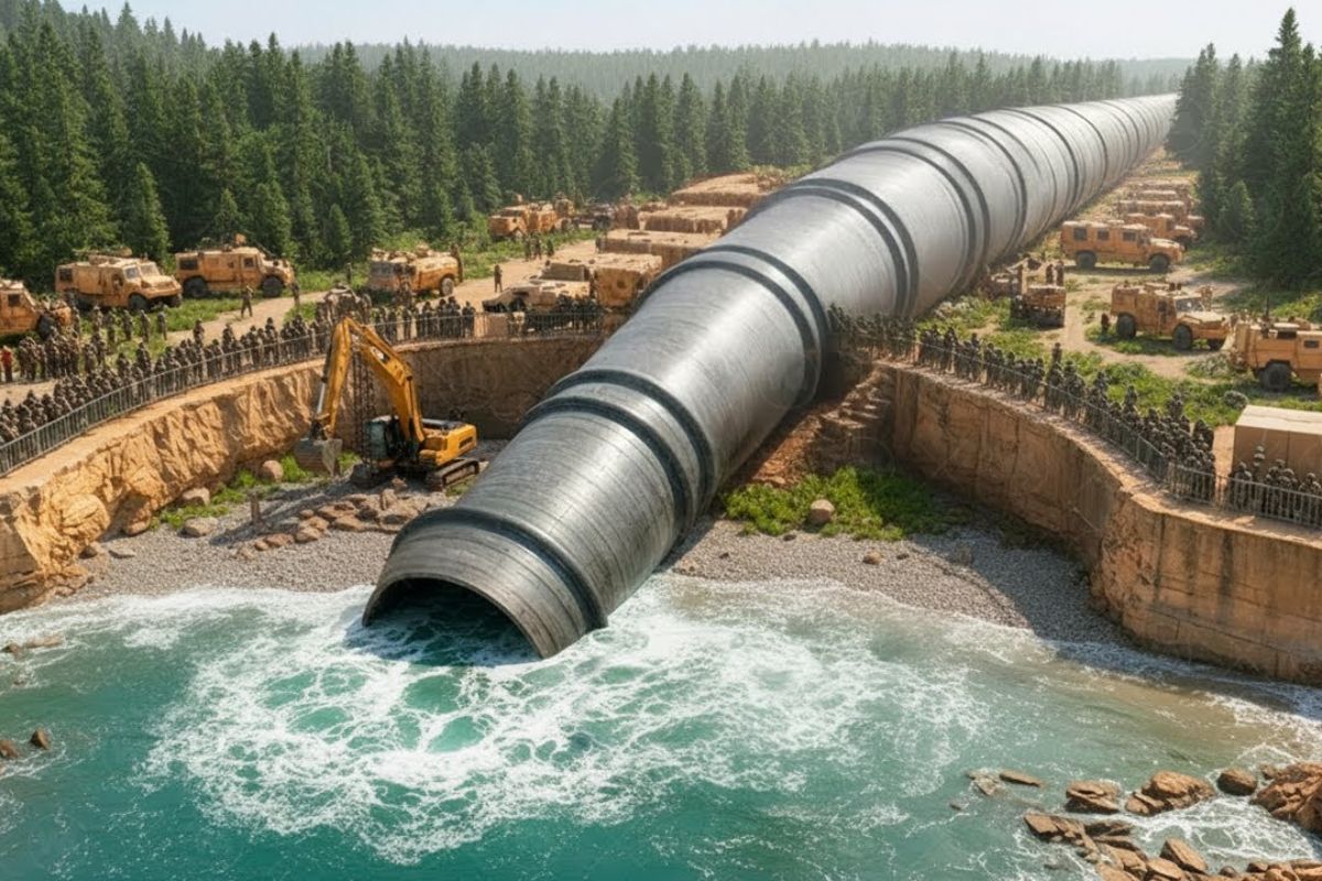


Poland Opened a Canal on the Vistula Spit to Not Depend on the Strait Controlled by Russia in Baltisk, Installed Lock to Stabilize Water Levels, Planned Continuous Dredging to Maintain Depth, and Used the Excavated Material to Raise an Artificial Island, Transforming Sovereignty into Regional Work.
Poland decided that it would no longer accept that the exit of a Polish lagoon to the Baltic Sea depended on a gate located on the Russian side. Instead of negotiating, waiting, or living with uncertainty, the country opted for a physical solution: cutting a strip of sand, reshaping the seabed, and creating a new route under its own control, with a canal, lock, dredging works, and even an artificial island built with sediment removed from the bed.
The project has become a symbol of sovereignty, but also a battleground for environmental, economic, and geopolitical disputes. It began in 2019, was inaugurated in September 2022, and faced a real dilemma: to function as a cargo corridor and ensure a future for the port of Elblag, it is not enough to open a canal, it is necessary to maintain depth, control currents, face criticism about ecological risks, and prove that the investment of hundreds of millions of euros makes sense.
The Geography That Trapped Poland Behind a “Door That Wasn’t Its Own”

In northeastern Poland, there is an extremely thin and elongated strip of land known as the Vistula Spit. It looks like a blade of sand separating two worlds: on one side, the open Baltic Sea, subject to winds, storms, and level variations; on the other, the Vistula lagoon, calmer, with its own dynamics, as if it were a reservoir protected by this natural barrier.
-
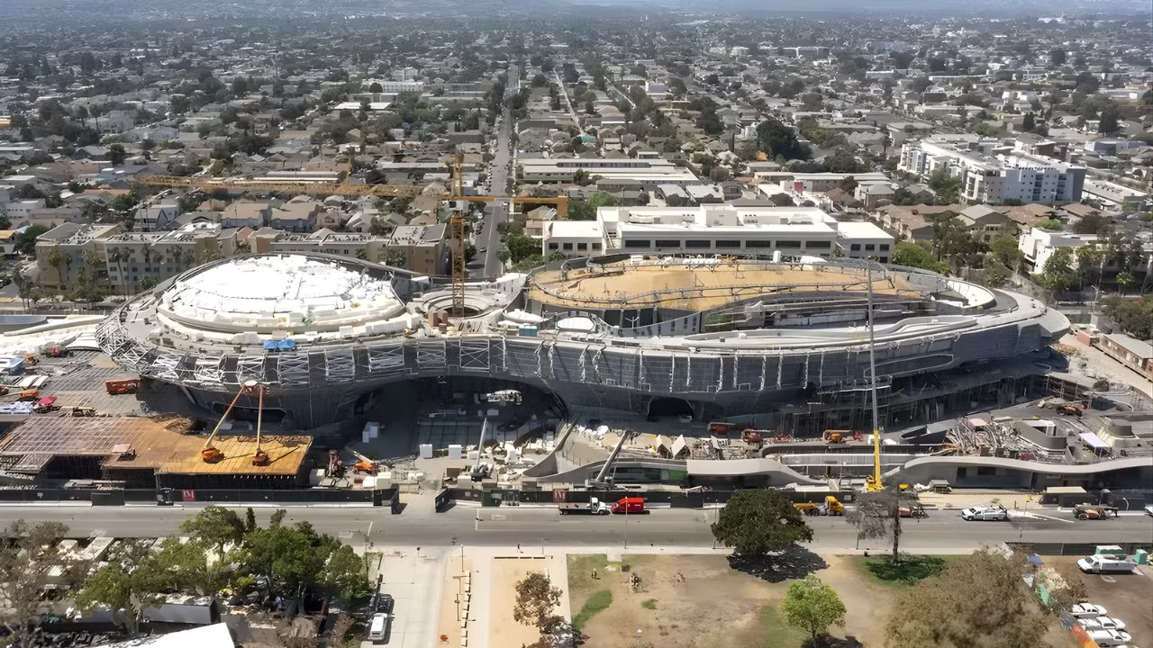
Created by George Lucas with over $1 billion, a futuristic museum in the shape of a spaceship with 1,500 curved panels is about to open in Los Angeles and will house one of the largest private collections of narrative art in the world.
-
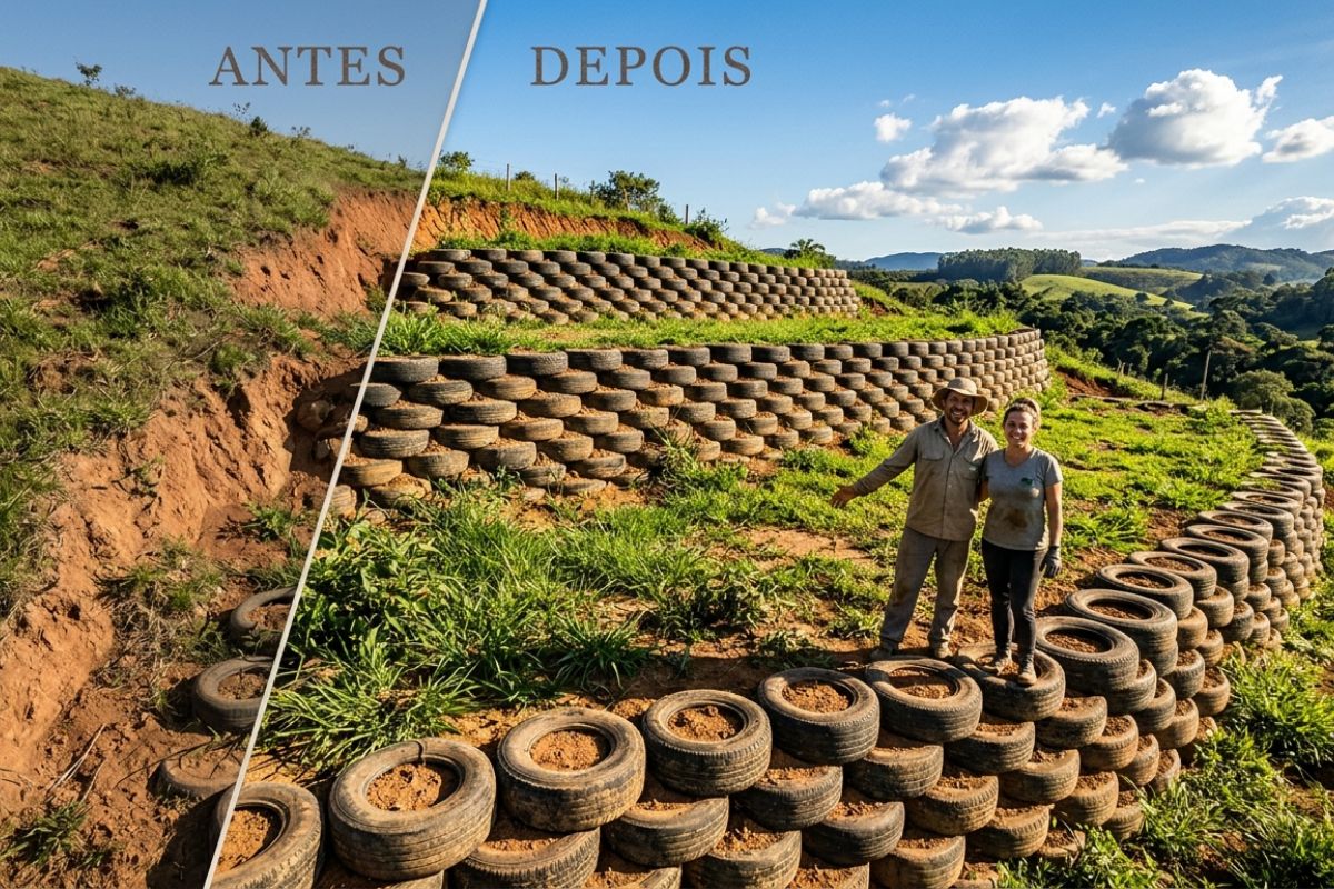
Couple shows how they built a retaining wall on their property using 400 old tires: sloped land turned into plateaus, tires are aligned, filled, and compacted with layers of soil, with grass helping in support and at almost zero cost.
-
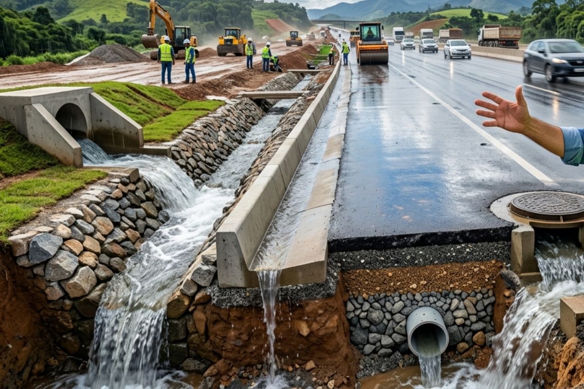
Engineer explains drainage during the rainy season: the difference between surface water and deep water, ditches, gutters, and water outlets on the road, as well as drains and drainage mattresses, to prevent erosion, aquaplaning, and flooding at the construction site today.
-
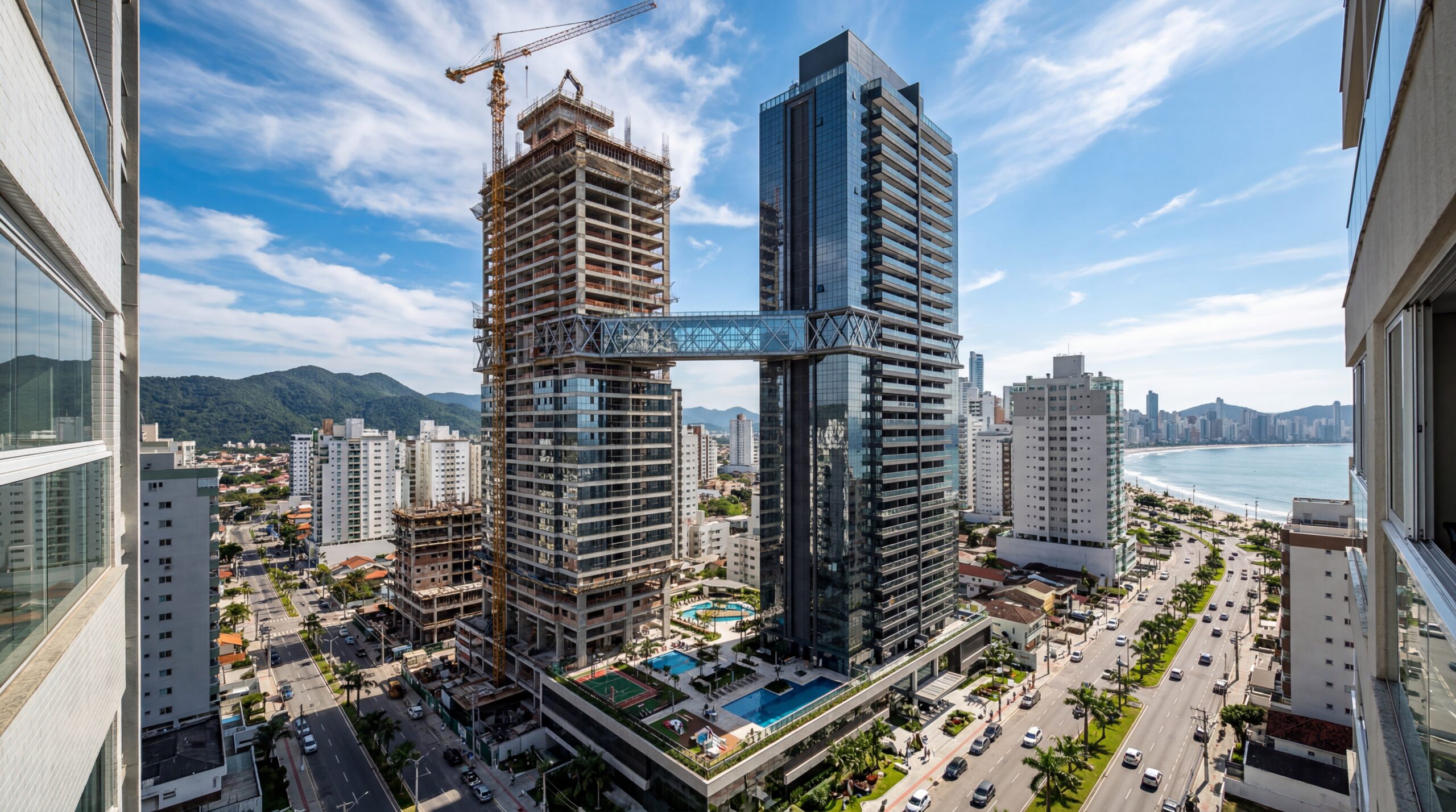
With 55 floors, 177 meters in height, a 15-meter walkway between the twin towers, ventilated facade, and 6,300 m² of leisure space, Ápice Towers already has one tower completed and another nearly at the top.

The lagoon is divided between two countries. Part is Polish and part is Russian, because the surrounding territory involves the Kaliningrad region. However, the big bottleneck was not “who has the water,” but “who controls the exit.” For decades, there was only one natural navigation route connecting the lagoon to the open sea: the Baltisk strait. The problem is that it is entirely on the Russian side. Direct result: any ship leaving Polish ports inside the lagoon and wanting to reach the Baltic Sea had to cross Russian territorial waters.
The Historical and Political Weight of Depending on a Russian Corridor
This dependence seems a technical detail when relations are calm, but it turns into a nightmare when politics sours. The scenario was compared to a backyard with a single exit gate located on the neighbor’s property: on paper, the neighbor says you can pass, but the key is not yours.
After World War II, territorial division solidified the situation. With Kaliningrad in the Soviet sphere, the strategic passage was on the other side. There were formal agreements allowing the transit of Polish vessels, but the very logic was bothersome: why does a country need permission to leave its own waters? In practice, it was enough for an increase in procedures, requirements, and restrictions for access to become “conditional” and insecure.
Elblag: The Port That Existed in the Lagoon but Had No Guarantee of Sea

The Polish port most cited in this story is Elblag. It is within the same hydrological system as the Gulf of Gdansk, but has always been at a disadvantage due to its dependence on the “gate” of Baltisk. When a port survives on trade, it needs guaranteed, predictable exits without the risk of political blockage.
Without that own exit, Elblag found itself trapped in a secular dilemma. The region saw other centers grow with direct and reliable routes, while its route depended on third parties. The canal turned into an attempt to correct a structural delay, not just a beautiful map work.
The Decision of 2019: Poland Begins to Dig to Gain Sovereignty

In 2019, Poland began the construction of the canal cutting through the Vistula Spit. The image seems simple: cut sand, and water from the sea enters, water from the lagoon exits. However, the real project involved much more than opening a hole. The port of Elblag is about 14 miles by water from the new opening, and the entire route needed to be navigable and reliable.
As soon as Poland began to dig, it entered an irreversible logic. A canal of this type needs to withstand storms, currents, erosion, and the constant conflict between two bodies of water with different rhythms. The work became a re-engineering of the environment, not a simple shortcut.
The Lock as a Central Piece: Why It Wasn’t Possible to Connect Water with Water Without Control
The most decisive technical point of the project is the lock. If the sea and the lagoon always had the same level, a direct cut would suffice. But the Baltic Sea is open and reacts to winds and storms, changing levels and currents. The lagoon is more stable, with its own flow and level.
If you open a narrow connection without a lock, nature tries to “equalize” the levels by itself. In a narrow corridor, this turns into strong, unpredictable, and potentially dangerous currents. Ships do not need a lottery to cross; they need predictability. The lock operates as a sealed chamber: the ship enters, the gates close, the water level is adjusted to match the exit side, and only then does the second gate open. It’s a hydraulic elevator that transforms an unstable crossing into a daily one.
The Reason for the Chosen Location: Cutting Where It Is Narrowest to Reduce Cost and Conflict
Poland did not cut the spit at just any point. The canal was planned at the narrowest part to reduce the amount of earth removed and consequently the total cost. Less excavation means less money spent and also fewer complications in environmental licensing and ecological compensation.
The reasoning was pragmatic: choose the spot where the project would have the greatest chance of advancing within the rules and with the least risk of legal blockages. Engineering here is also political engineering, because where you dig changes the intensity of protests, lawsuits, and environmental demands.
The Cost That Exploded: From 190 Million to 420 Million Euros
The project was initially estimated at around 190 million euros, but the final amount rose to approximately 420 million euros. This fueled obvious criticisms: “why pay hundreds of millions for a cut that looks narrow and shallow?”
The central argument is that the canal was not designed for mega ships, nor to become a “new Suez.” It was designed for relatively smaller vessels, with a length of around 330 feet, a width of about 66 feet, and a draft of approximately 13 to 15 feet. The goal was not to dominate global trade, but to make a specific route functional, predictable, and under Polish control.
The Great Controversy: Disturbing the Bottom Is Not Just Disturbing Sand
One of the heaviest criticisms is environmental. The lagoon does not only have sand at the bottom. It has accumulated sediments with phosphorus, associated with sources such as sewage, livestock, and fertilizers. While this material remains deposited, the impact can stay “quiet.” The risk arises when dredging and changes in current disturb the bottom and put this chemistry into circulation.
The most cited fear is the intensification of cyanobacteria, considered more toxic in the lagoon than in the open sea. The concern is that the work may cause difficult-to-reverse imbalances because with water, there is no “fixing it later” like with a bridge. If the environmental calculation fails, the return can be slow and expensive.
Russia Against: From Environmental Argument to Military Fear
Russia opposed the canal and continues to criticize it. One argument is that the canal could allow, at least in theory, the entry of military ships linked to NATO into the lagoon, bypassing Russian facilities in Baltisk and creating a risk for Kaliningrad.
There were also suspicions within Poland itself that the project might have military motivation, with speculation about defense infrastructure in Elblag. The counter-argument is the physical limit: the lagoon is shallow, which reduces its practical military potential. Still, the canal has become a geopolitical symbol because it removes Russia’s power as the “gatekeeper”, even though Russia still holds regional weight.
The Paradox of Depth: Canal Ready, Lagoon Shallow, Ship Runs Aground
The canal was built with a depth cited at around 16 feet, allowing ships with a draft of up to about 15 feet to pass through this initial section. However, afterwards, the ship enters the lagoon, which has an average depth of 7 to 10 feet and a maximum of about 17 feet.
This creates a paradox that has become ammunition for critics: the ship crosses the canal without a problem and may run aground shortly after. In practice, large vessels avoid the route because the risk of scraping the bottom is real. The “new gate” may open to a passage that is still not fully prepared.
The True Bottleneck Was Not the Sea, but the End of the Road: The Elblag River
For the route to be truly useful to Elblag, the final stretch needs to be deepened, especially a section of the Elblag River about 2950 feet long. This segment has become the most stubborn bottleneck. The work got stuck in disputes and bureaucracy, delaying the promise of a genuine commercial corridor.
Only in January 2024 did the new government under Donald Tusk indicate it would commit to completing the missing part. The cited plan is to maintain the route with a depth of about 16 feet along the entire length, with a width varying approximately between 66 and 197 feet, allowing vessels of up to about 328 feet in length and a draft of 15 feet to reach the port. In other words: the project needs a “second phase” to fulfill the promise.
Continuous Dredging: The Canal Is Not a Finished Work, but a Work That Must Be Maintained
Even with initial dredging, storms, river sediment, and constant movement of the bottom rapidly reduce depth. If Poland does not maintain dredging, ships will scrape the bottom again, and the route will lose its utility.
The cited solution involves a dedicated dredger, built to operate continuously. The reasoning is simple and expensive: opening is an expense, maintaining is another recurring expense. Without maintenance, the canal ceases to be a corridor and becomes a geographical scar.
The Dredger and the Logistics: Underwater Vacuum Cleaner and Pipeline to the Island
Poland ordered a dedicated dredging vessel from a Finnish company, created specifically for the work of maintaining depth.
The dredger was launched on September 19, 2023, and is described as a robust, wear-resistant machine made for lagoon conditions.
It operates like a giant underwater vacuum cleaner: it sucks sand, silt, and gravel, pumps into a compartment, and transfers the material through a pipeline for land recovery. In this case, for the artificial island. This creates a cycle where the bottom is cleaned, and the excavated material becomes “raw material” immediately.
The Artificial Island: 445 Acres, 10 Feet Above Sea Level, and Restricted Access
The excavated material from the canal and subsequent dredging became the foundation of an artificial island of about 445 acres. It is expected to rise approximately 10 feet above sea level. The plan is not tourism: visitors will not be allowed, as the island will not be a park nor a resort.
It is presented as environmental compensation for the impact of construction. The proposal is for plants to take root and birds such as grebes and swans to settle.
An important detail is that the island has reportedly survived winters, including periods with ice deposits, and its ability to withstand reinforces that the engineering plan is holding. Poland literally gained new land as a byproduct of the work.
The Actual Use So Far: More Tourism and Leisure Than Cargo
Despite the official inauguration in September 2022, commercial use is still very limited. Between January and December 2024, only 31 cargo ships passed through the canal. Fishermen hardly utilized it, with about 32 vessels in the same period.
The main users were recreational boats: 1466 passages. This fuels the criticism that, in its current state, the route functions more as a tourist attraction than as a robust transport corridor. The canal exists, but the logistical promise still depends on the final dredging and constant maintenance.
The Internal Economic Critique: “Why Dig When Gdansk Is Close?”
Another opposing argument points out that Poland already has access to the sea via Gdansk, a large port about 37 miles from Elblag, with a terminal capable of handling the largest ships.
The logic would be to load containers, use a fast highway, and in about an hour the transport would reach Elblag.
From this perspective, digging a canal costing hundreds of millions of euros would be unnecessary from a practical standpoint.
Former president Andrzej Duda rejected this criticism by emphasizing the symbolic aspect: it is not about passing the largest ships, but about opening a route of its own so that Poland does not have to ask permission from a country with which it has poor relations. In this narrative, the canal is sovereignty materialized, not just logistics.
The Regional Bet: High Unemployment and the Promise of a “New Future”
The work was also marketed as a driver of regional growth. The cited region faces unemployment around 16 percent, while the national average is close to 6 percent. For local residents, the canal is an opportunity, even if the beginning seems slow.
Before the opening, the port of Elblag handled about 200,000 tons of cargo annually. Optimistic projections speak of increasing capacity to 22 million tons by 2045, a number compared to large ports. It is a gigantic promise used to justify the investment and persistence in the project.
The Canal as a Total Work: Politics, Engineering, Ecology, and Narrative
Poland did not just build a canal. It built a national narrative of route independence, faced environmental and economic criticisms, and opened a dispute with Russia that mixes military fear, territorial control, and symbolism. At the same time, it created an artificial island as compensation and as a continuous deposit for dredged sediments.
The project is a work in progress: canal open, lock functioning, continuous dredging, island growing, and the final part to make access to Elblag truly useful still being pushed forward. The result is a case where a country literally cuts its own coast to redefine its regional future and its relationship with the sea.
Do you think Poland is making a smart move by investing so much to not depend on Russia, or does this canal risk becoming a symbol too expensive for too little practical utility?


Sim, é um projeto interessante e inteligente. Existe um ponto que não foi citado: o custo de transporte, pois navio é mais econômico que trem ou rodovia. Um erro que se comete no Brasil, com uma costa enorme, é não investir pesado em transporte por cabotagem, como existia no passado.