 Portuguese
  English
  Spanish
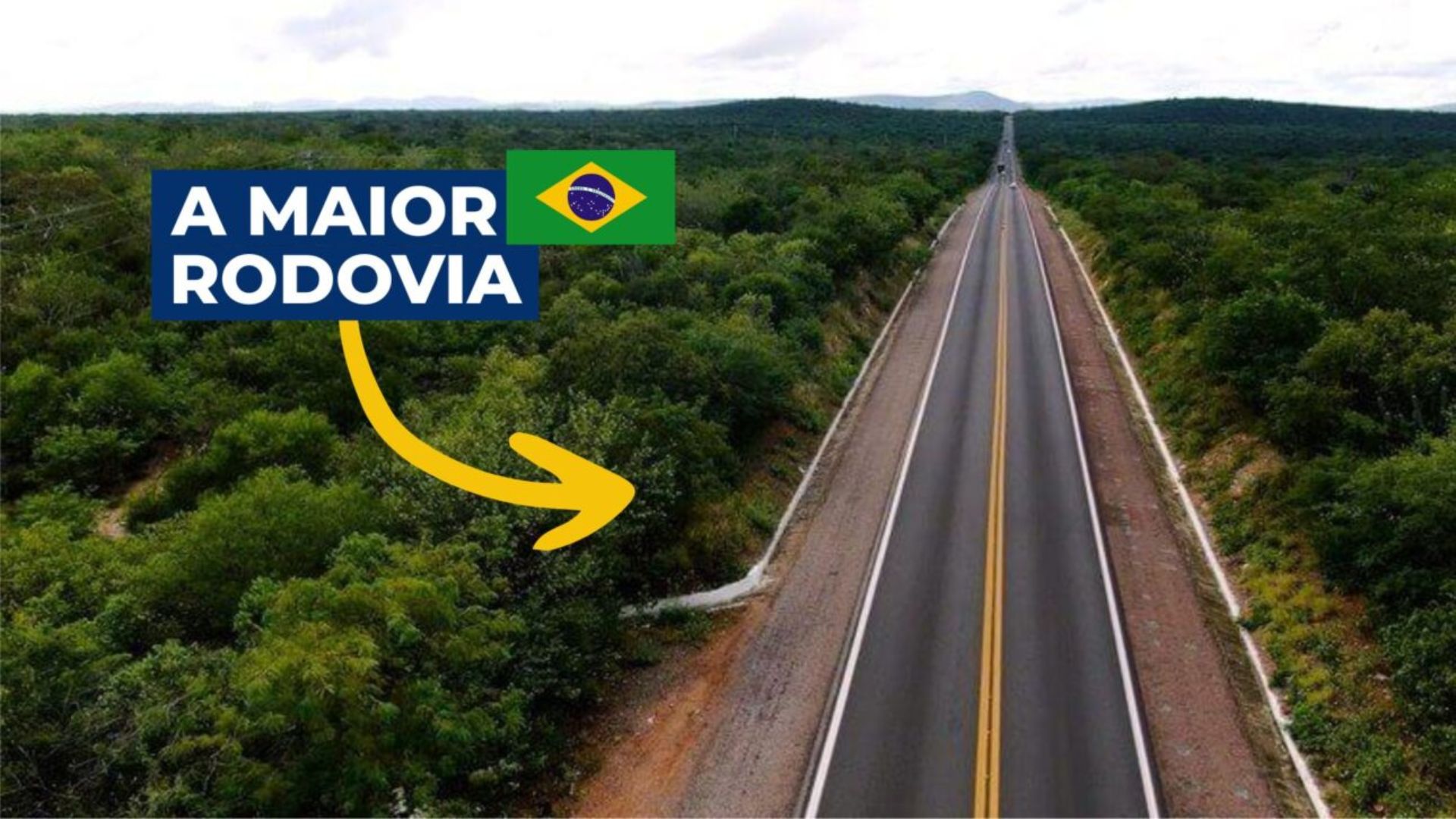


Highway Corridor That Connects Strategic Regions of Brazil and Brings Together Some of the Busiest and Most Challenging Segments for Freight and Passenger Transport.
The BR-116 is considered the longest highway in Brazil, with about 4,660 km between Fortaleza, in Ceará, and Jaguarão, in Rio Grande do Sul.
Along its length, it cuts through 280 cities in ten states and has established itself as one of the main corridors for freight and passenger transport, even in segments classified by authorities as high-risk areas due to the volume of accidents and heavy traffic.
Connection Between Brazilian Cities and Regions
The highway starts in Ceará, travels through the interior of the Northeast, crosses segments of Paraíba, Pernambuco, and Bahia, reaches Minas Gerais, and then cuts through Rio de Janeiro, São Paulo, and Paraná until it arrives in Santa Catarina and the southernmost part of Brazil.
-
At 73.8 meters tall, the world’s tallest teapot-shaped building has 15 floors, ensures stability, and impresses with an internal space of 28,000 cubic meters.

-
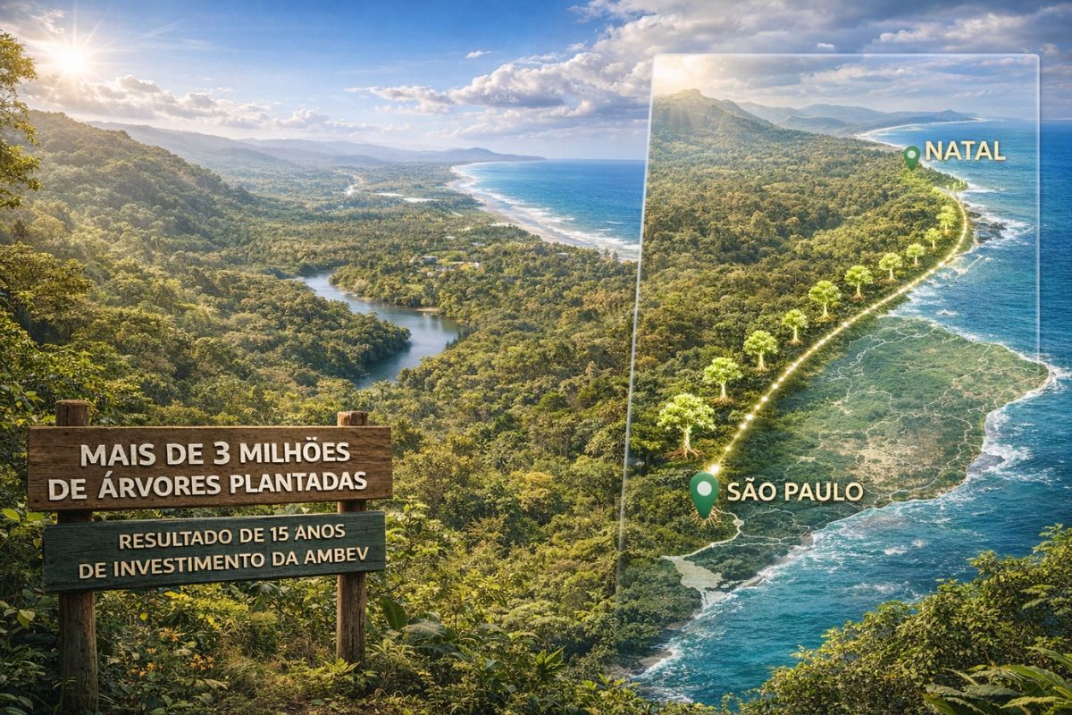
Ambev has planted over 3 million trees and restored an area equivalent to the coastline from São Paulo to Natal, and the result after 15 years of silent investment has finally appeared for all of Brazil to see.
-
A new AI collar technology for cattle eliminates physical fences, creates virtual barriers, monitors animals 24/7, and detects changes in behavior and health.

-
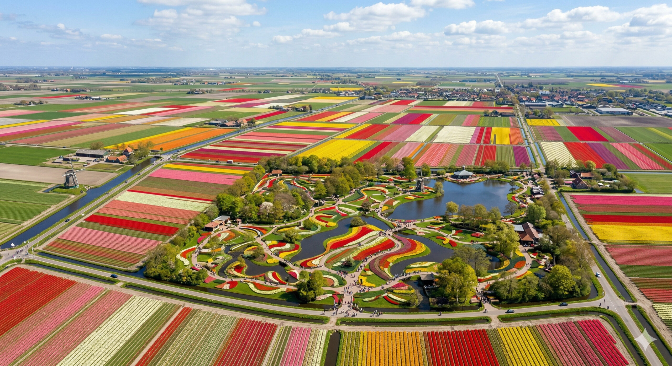
For a few weeks each year, an entire country blooms with billions of tulips, creating a mosaic of colors visible from the sky, while a single garden gathers more than 7 million flowers and attracts visitors from around the world to one of the most impressive shows in Europe.
Along this route, it connects urban centers such as Fortaleza, Rio de Janeiro, São Paulo, Curitiba, and Porto Alegre, in addition to regional hubs that rely on the route for the circulation of goods and daily commutes.
Created in the 1930s, the BR-116 started with a segment between Fortaleza and Feira de Santana.
With the increase in demand and the economic expansion of the country throughout the 20th century, it was extended to the Southeast and South, becoming an essential corridor for logistical integration among different regions.
The strategic role of the highway is pointed out by infrastructure experts, who emphasize its function in connecting industrial, agricultural, and port areas.
The constant flow of trucks transports grains, fuels, meat, inputs, and finished products that supply various Brazilian regions.
Well-Known Segments: Dutra and Régis Bittencourt

Within its route, the BR-116 encompasses segments nationally known for their importance.
Between Rio de Janeiro and São Paulo, it operates under the name Presidente Dutra Highway, a direct connection between the two largest metropolitan regions in the country.
Between São Paulo and Curitiba, it is known as Régis Bittencourt Highway, used for the distribution of industrial and agricultural production from the South and Southeast.
According to technical studies, this segment features sharp curves, mountainous areas, and heavy truck traffic, characteristics associated with a higher incidence of accidents.
In recent years, expansion and duplication works in specific segments, such as in the Serra do Cafezal, have been pointed out by concessionaires and authorities as responsible for reducing serious collisions after the completion of the interventions.
Segments in Bahia, Minas Gerais, Rio de Janeiro, and the South have also gone through concessions that include maintenance, user assistance, and the execution of improvement works.
Freight Flow and Passenger Circulation
The BR-116 interlinks industrial zones, logistics centers, and agro-industrial areas from the Northeast to the South of Brazil.
This structure results in tons of freight circulating daily on the highway, especially in long-distance trucks.
The flow of passengers is also significant.
Interstate and intermunicipal buses use the highway as the main axis between capitals and medium-sized cities.

In metropolitan areas, the circulation of cars, vans, and chartered buses increases the demand on infrastructure, especially during peak hours and holiday periods.
According to mobility experts, this combination of different vehicle profiles requires capacity compatible with the growing volume of traffic and continuous reinforcement of safety measures.
Accidents and High-Risk Segments
The BR-116 frequently appears in surveys by the Federal Highway Police as one of the highways with the highest number of accidents in the country.
Recent data indicates that the highway accounts for a significant portion of the occurrences recorded on federal highways.
The segment of Régis Bittencourt, between São Paulo and Paraná, is often cited in studies by the National Transport Confederation and in road safety analyses as one of the most critical, due to the terrain, low visibility curves, and heavy truck flow.
In Minas Gerais, the situation also draws the attention of authorities and industry entities.
Segments with a single lane, rugged terrain, sharp curves, and heavy traffic contribute to raising the number of serious accidents.
In certain recent periods, state surveys pointed to the BR-116 as one of the roads with the most deaths recorded in the state, partly due to the intense traffic and road profile.
Experts consulted in public studies on road safety point to structural factors, such as lack of duplication in long segments, direct urban accesses to the track, and reduced visibility limits, among the elements that help explain the frequency of occurrences along the BR-116.

Works, Concessions, and Demands for Improvements
In recent years, duplication interventions, installation of walkways, signaling improvements, and expansion of safety devices have been carried out in different segments of the highway.
The length of the road, however, means that there are still long segments with a single lane, rugged terrains, and areas that depend on large-scale works to meet the current traffic volume.
Transport sector professionals emphasize that regions with high truck circulation require constant pavement maintenance, as well as structural expansions to reduce congestion and increase safety.
Demands for additional duplications, bridge reinforcements, alignment adjustments, and expansion of user support services arise frequently in technical evaluations related to the BR-116.
With interventions happening at different paces along the 4,660 km of length, users daily contend with varying road conditions—modernized segments and sections still awaiting structural works.
In light of this context, what will be the impact of the next phases of investments on the safety and fluidity of one of the country’s main highway routes?


SIM , UMA RODOVIA MUITO IMPORTANTE PARA A CONECÇÃO NACIONAL , LIGANDO NOSSAS CULTURAS , HÁBITOS E FORTALECENDO NOSSA PRODUÇÃO E RIQUEZAS , FAZENDO NOSSA ECONOMIA DIVERSA PARA PRODUTOS E SERVIÇOS .
UMA RODOVIA QUE INTEGRA NOSSO POVO PARA UM PAÍS DE VÁRIAS , DIVERSAS E FOMENTADORAS MODALIDADES ECONÔMICAS QUE NOSSO POTENCIAL CIRCULANTE NOS PROPORCIONA .
Clique Google maps e pesquise Touros RN e verá a placa indicativa de distância marcando 4765 km.
Se a BR 116 tem 4660 km ela não é maior que a BR 101 que tem 4765 km.