 Portuguese
  English
  Spanish
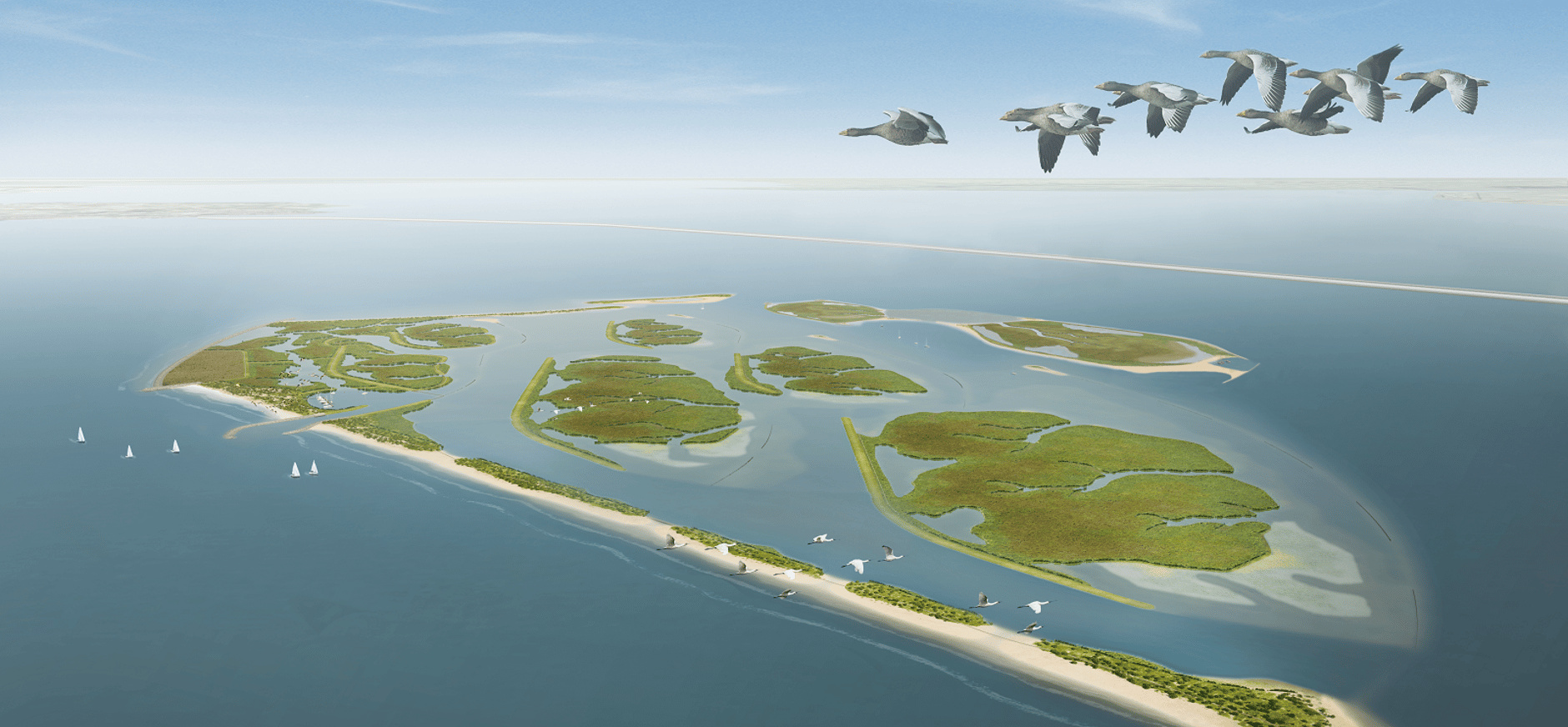
In the Netherlands, the Marker Wadden project transformed mud, sand, and clay taken from Lake Markermeer into artificial islands to address decades of environmental degradation, recover natural shores, reduce impacts of turbid water, and create new habitats for birds, fish, and aquatic vegetation
In Lake Markermeer, in the Netherlands, a large-scale project transformed sediments accumulated over decades into raw material to build artificial islands, recover shallow areas, and create new natural shores.
The initiative, called Marker Wadden, became one of the most well-known cases in Europe of engineering used to restore ecological processes in an environment deeply altered by hydraulic works.
The basis of the proposal was simple in idea but complex in execution: to extract sand, clay, and silt from the lake itself to raise an archipelago with beaches, marshes, wetlands, and transition areas between land and water.
-
After seeing a 100% automated factory in Shanghai, the president of Honda exclaimed, “we don’t stand a chance”; China accelerates electric cars, cuts costs, and exposes the brand’s crisis worldwide.

-
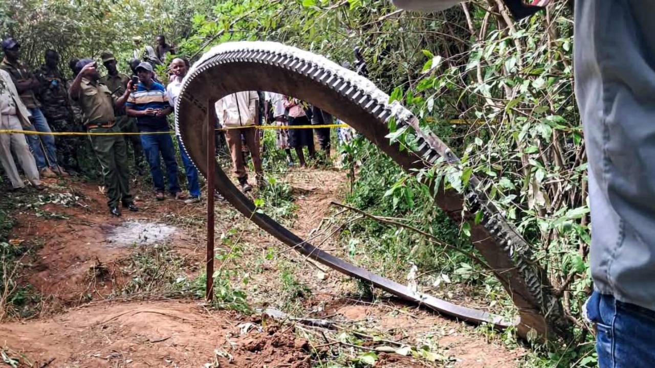
A giant half-ton ring fell in Kenya from space, and more than a year later, scientists still do not know where it came from.
-
Dubai eliminates the term “housewife” from official documents and adopts “generation builder,” redefining the role of mothers and changing the way society views motherhood.

-
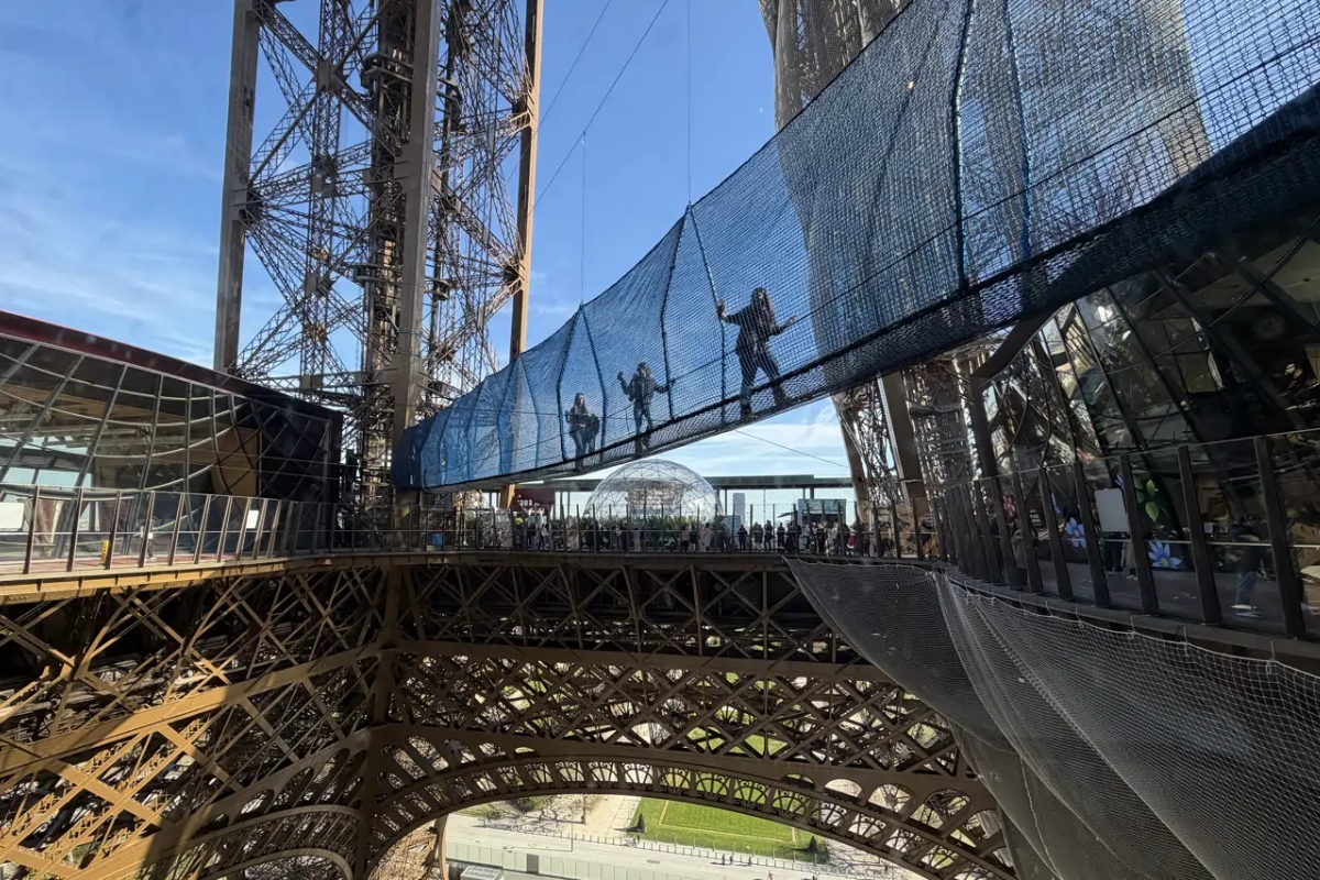
60 meters above the ground, the Eiffel Tower once again offers a crossing over the void on a suspended walkway that has already attracted more than 24,000 people and transforms the visit into an experience of tension and an open view over Paris.
Instead of importing material, the project decided to work with what was already at the bottom of Markermeer, specifically the excess sediment associated with some of the environmental problems of the system.
How Markermeer Got to This Point
Markermeer is about 700 square kilometers and was separated from IJsselmeer in 1976, with the completion of the Houtribdijk dyke between Enkhuizen and Lelystad. Before that, the system had a different hydrological dynamic.
After compartmentalization, the lake became disconnected from the sea and rivers, began to function more stagnantly, and lost a large part of its natural shores due to flood protection works and land reclamation.
This set of changes favored the accumulation of sludge at the bottom and the frequent resuspension of fine particles by wind and waves, because the lake is relatively shallow, with depths around 2 to 4 meters in various stretches.
Turbid water began to hinder light entry, limiting the production of algae and aquatic plants and reducing the food base for fish and birds. Official Dutch sources describe a marked ecological deterioration in recent decades.
The Bet on Reconstructing the Landscape with the Problem of the Lake Itself
It was in this context that the artificial islands of Marker Wadden emerged. The project was initiated by the conservation organization Natuurmonumenten, in partnership with the government agency Rijkswaterstaat and other participants.
The proposal was to use the sediment available in the lake to reconstruct lost habitats, such as gentle shores, mudflats, flooded areas, and shallow zones important for the breeding, shelter, and feeding of different species.
Official sources treat Marker Wadden as one of the largest nature restoration projects in Western Europe, aiming to restore an area of up to 100 square kilometers.
Recent scientific studies also describe the site as an archipelago of approximately 1,000 hectares built from 2016 with dredged material from Markermeer itself.
What the Latest Studies Show
The results measured so far indicate that the intervention produced new habitats rapidly. The official summary of the first five years of research points out that birds, fish, and aquatic plants appeared soon after construction, and that the project considerably increased the habitat availability for various bird species in Markermeer.
The same material informs that the islands also began to function as a connection point between other ecological areas in the region.
In the water, the overall effects on the lake’s transparency are still treated with caution. Research coordinated in the KIMA program recorded a clearer water zone on the protected side of the islands but noted that the total effect on the clarity of Markermeer could not yet be conclusively defined, partly because works and maintenance activities also stirred up sediments. Nevertheless, researchers highlighted that the creation of turbidity gradients already represented an ecological gain.
Studies published in 2024 and 2025 reinforced this picture. A fish survey indicated that densities of young individuals were higher in protected bays and wetlands with nutrient-rich sediments on the islands, suggesting that these zones began to offer more favorable conditions for recruitment.
Another study showed that active restoration actions accelerated the establishment of vegetation, although natural development favored greater plant diversity over time.
In 2026, a study on shorebirds described Marker Wadden as an artificial freshwater archipelago located about 3 kilometers from the shore and concluded that these constructed areas can provide, at least temporarily, substantial feeding habitat for species such as the black-winged stilt and the avocet.
Why the Project Attracts So Much Attention
The case has become a reference because it combines dredging, landscape design, and ecological restoration in a single project.
It is not just about creating land where there was once water, but about redesigning a degraded environment so that it can once again offer diverse shores, shelter, and food.
Instead of fighting nature with rigid structures, the logic was to build conditions for natural processes to re-emerge.
For this reason, the artificial islands of Marker Wadden attract attention far beyond the Netherlands. The project shows that an environmental liability, in this case, the accumulation of sediments, can become strategic material for restoring degraded ecosystems.
The latest data still call for long-term monitoring, especially regarding water quality on a whole lake scale, but already indicate that the intervention achieved something rare: using heavy engineering to restore natural complexity to a landscape simplified by decades of human works.


Seja o primeiro a reagir!