 Portuguese
  English
  Spanish
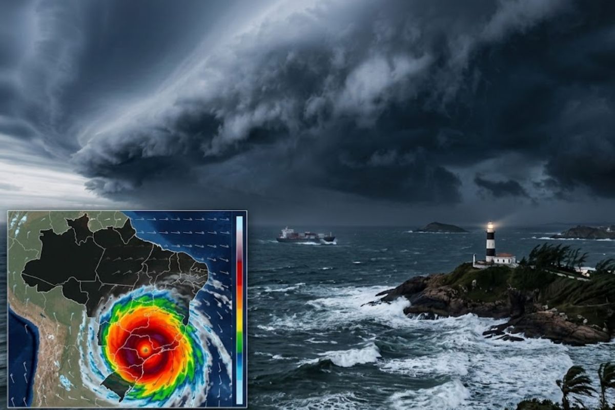
Between Friday (6) and the Weekend, a Trough in the South Is Expected to Evolve Into a New Extratropical Cyclone, Increasing the Chances of Severe Weather. While the Southeast Experiences a Break and Heat, Bahia, Maranhão, and Areas of the Midwest May Exceed 100 mm, With Strong Gusts and Localized Flooding Throughout the Week
The new cyclone that is starting to form at the turn of the month will play a key role in a week where the atmosphere alternates between relief and risk, depending on the forecast. The combination of humidity and heat typical of the end of summer creates the “fuel” for heavy showers and, when systems are organized, for episodes of severe weather.
The most obvious change appears from Friday (6), when instability intensifies in the South. At the same time, other areas of Brazil are still under forecast of significant accumulations, especially in places that may exceed 100 mm and experience disruptions such as flooding, as well as intense gusts in more isolated storms.
Why the Turn of the Month Usually Accelerates Severe Weather in Brazil
March is known for heavy rainfall in much of the country because there is still accumulated heat from summer and plenty of humidity available. This scenario favors clouds with great vertical development, which can produce heavy showers in a short time and, in specific situations, hail and more intense winds.
-
For the first time in history, the Brazilian Air Force conducted a highly complex inspection on the C-99 jet independently, without relying on foreign companies, marking a new level of logistical autonomy and operational sovereignty.

-
Beet greens that end up in the trash in many kitchens contain a high concentration of antioxidants, and a 2025 study shows that extracts may have even more potent activity when transformed into microparticles.

-
Something was orbiting Earth before any human launched a satellite into space: scientists have found thousands of unexplained flashes in old photos of the sky, and a NASA researcher says the evidence points to non-human intelligence.

-
There is a gap of hundreds of kilometers between weather observation points in the United States, and now drones flying at 6,000 meters altitude in strong winds are filling this gap to predict tornadoes before they kill.

However, the turning point is not just about “more rain”: it’s when the atmosphere begins to have organization mechanisms, such as low-pressure bands and instability systems that enhance moisture convergence. It is in this context that a trough can pave the way for the formation of a new extratropical cyclone, changing the wind pattern and rainfall distribution.
From the Trough to the New Cyclone: What Changes in the South and Why
The trough is a long band of low pressure that helps channel more humid and unstable air, creating an environment conducive to storms.
The indicated trend is that, starting from Friday (6), this trough will increase instability in Rio Grande do Sul and Santa Catarina, marking the transition after drier and hotter days.
By the weekend, the expectation is that the system will evolve and organize near the South, characterizing the formation of the new extratropical cyclone.
When this happens, the risk shifts from just “showers” to include heavier and more persistent rain, the chance of hail in storms, and gusts that can exceed 100 km/h in areas under more intense storms, especially in the three states of the region.
Where the Rain May Exceed 100 mm and Why It Matters for Local Impacts
While the new cyclone captures attention in the South, the first week of March also raises concerns about accumulations above 100 mm in other areas.
In the Northeast, forecasts indicate heavy rainfall in much of Bahia (with emphasis on the coast), in Maranhão, and in southern Piauí, with volumes capable of exceeding 100 mm and increasing the risk of storms and flooding, especially where urban drainage is already limited.
In the Midwest, rain is expected to be more frequent in northern Goiás and northeastern Mato Grosso, with the possibility of isolated storms and accumulations that may exceed 100 mm, especially in the northern parts of these states.
The logic of impact here is simple: when intense rain occurs in sequence, the soil saturates, small streams respond more quickly, and flooding can occur even without a “big” system passing through.
Southeast Between a Break and the Return of Instability: The Deceptive Interval
After days of intense precipitation that caused flooding and landslides in Minas Gerais, the indicated trend is for a break in the most affected areas.
The expected pattern is for warmer and drier weather in most of the Southeast until the weekend, which usually reduces the frequency of widespread rain and provides a breather for cleaning, restoring slopes, and reorganizing routines.
Nonetheless, this interval does not mean a total absence of rain: there is a forecast for light rain on the coast of São Paulo and Rio de Janeiro, and isolated showers in northern Minas Gerais.
The point of concern will return at the beginning of next week, with the arrival of a new cold front, when rain is expected to return and can accumulate around 50 mm in areas under the instability zone, a volume that, depending on the recent history of the municipality, may be enough to reignite problems.
North with Contrasts and the March Reading That Helps Understand the Puzzle
In the North, the picture is one of contrast: instability remains more present in southern Pará, Tocantins, and eastern Amazonas, with showers intensifying in the afternoon.
There is room for isolated storms, especially in Acre and Rondônia, while Amapá and Roraima have more stable weather with little significant rain throughout the week.
This mosaic corresponds to the indication that, even with the new cyclone acting in the South, March rainfall may be below the historical average in that region and also in parts of the North, while the Northeast, Midwest, and Southeast tend to record above-average precipitation.
In practice, this helps explain why a severe weather event can coexist with a month that, on balance, is not necessarily “very rainy” in all areas: intensity and distribution do not always go hand in hand.
This week’s outlook mixes clear signals of atmospheric organization in the South, with the new cyclone raising the risk of severe weather and strong gusts, and a band of heavy rain in points of the Northeast and Midwest, where exceeding 100 mm can mean real impact in daily life.
In the Southeast, the break may bring relief, but the return of the cold front shifts attention to the evolution at the beginning of next week.
To understand what this might mean in your city: when it rains heavily, does the biggest problem usually involve wind, flooding, hail, or landslides?
And do you prefer to prepare by following radar/alerts or by observing local signs (wind shifting, dark clouds, stuffiness)?


-

-

-

-

-

-

80 pessoas reagiram a isso.