 Portuguese
  English
  Spanish


Located 670 kilometers from Riyadh, the city of Jubbah occupies the bed of an ancient lake measuring 20 kilometers by 4 kilometers, houses about 5,000 inhabitants, maintains pivot-irrigated agriculture, and concentrates more than 7,500 records of rock art dating back up to 10,000 years in the Nafud desert.
The oasis city of Jubbah, located about 670 kilometers northwest of Riyadh, occupies the bed of an ancient lake extending 20 kilometers and 4 kilometers wide, maintains pivot-irrigated agriculture, and preserves thousands of ancient rock art records amid the hyper-arid Nafud desert.
Present City Developed Over Paleolake with Dozens of Kilometers and Deep Depression
Jubbah is situated in a bowl-shaped depression, remnants of a paleolake that has shaped local human occupation over millennia. Parts of the city lie hundreds of meters below sea level compared to the surrounding dunes, according to records from NASA’s Earth Observatory.
This geographical configuration distinguishes Jubbah from other desert settlements. The ancient lake acted as a natural reservoir, allowing human settlement in a region now marked by hyper-arid conditions and significant dune mobility.
-
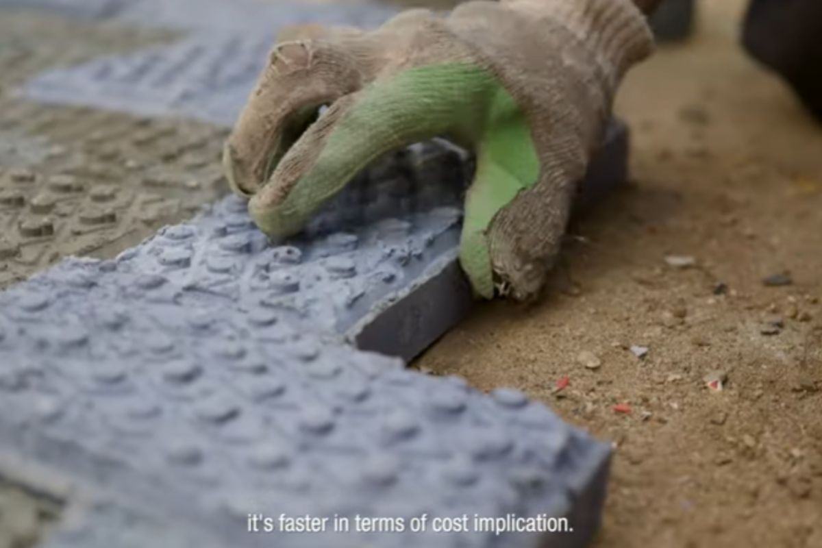
In Kenya, engineer Nzambi Matee created “bricks 2.0” using packaging plastic: a mixture with sand, heated and pressed; they are 5 times more resistant, already have official licensing, and are being used in streets and construction projects.
-
More than 20,000 positions could be opened, and thousands of technicians are starting to be trained in Brazil, as the expansion of data centers creates an urgent race for professionals to keep the internet, cloud, and artificial intelligence running 24 hours a day.

-
China approves the 15th Five-Year Plan 2026-2030 to become a global power: prioritizes brain implants, 6G with AI, humanoid robots, flying cars, quantum technology, and nuclear fusion, while strengthening defense and the economy.

-
HONOR X80i arrives with a massive 7,000 mAh battery, a 120 Hz AMOLED display with a brightness of 6,500 nits, and the new Dimensity 6500 Elite chip, promising up to 22 hours of video playback and impressive performance in casual gaming.


Even after the advance of desertification in the Arabian Peninsula, the area has maintained conditions favorable for continuous occupation. The persistence of the underground aquifer has been crucial for the survival of the settlement over time.
Underground Aquifer Sustains Circular Agriculture in the Midst of the Hyper-Arid Desert
Currently, Jubbah is home to around 5,000 inhabitants and continues to be a regional agricultural hub. Production is concentrated in center-pivot irrigation systems, which create circular fields visible from space in contrast to the surrounding arid landscape.
The water used for irrigation comes from the same aquifer that supported the ancient lake. While most lakes in the region dried up about 5,000 years ago, Lake Jubbah likely persisted longer due to this underground reserve.
This water availability explains the continuity of human occupation and the historical role of the site as a reference point for populations crossing the desert throughout different periods.
1,264-Meter Mountain Creates Wind Shadow and Protects Settlement from Dunes
At the western edge of the paleolake rises Mount Jabal Umm Sinman, standing 1,264 meters tall. Its name means “mountain of the two-humped camel,” in reference to the appearance observed at ground level.
The prevailing winds in the region blow from west to east. This direction causes the mountain to generate a wind shadow that significantly reduces sand transport towards Jubbah, protecting the city from advancing dunes.
From ground level, the city is not visible due to its lowered position within the paleolake. This combination of terrain and natural protection has contributed to the stability of the settlement over generations.
Thousands of Prehistoric Petroglyphs Record Human Presence for At Least 10,000 Years
The slopes surrounding Jabal Umm Sinman concentrate one of the largest collections of rock art in Saudi Arabia. In total, about 5,500 inscriptions and 2,000 representations of animals have been identified carved into the rocks.
Among the records, there are ibex, leopards, ostriches, dogs on leashes, and more than 1,000 camels. The carvings date back at least 10,000 years and indicate continuous human occupation long before the foundation of the present city.
A faint road visible near Jubbah likely corresponds to routes used by prehistoric travelers. The collection integrates a site recognized as a World Heritage Site, alongside other nearby locations such as Shuwaymis.
Region Integrates Wide Archaeological Context of Northern Saudi Arabia
Jubbah is situated in an area considered central for the study of rock art and paleolithic structures in Saudi Arabia. About 250 kilometers to the northeast lies Al Naslaa, a rock formation covered in prehistoric carvings.
Recent research has also identified giant structures in the region shaped like pipes, dating back about 8,000 years. These findings reinforce the importance of northern Arabian Peninsula as a historic corridor of human occupation.
The collection of archaeological and geographical data reveals how natural factors, such as terrain, wind, and groundwater, have conditioned human occupation in Jubbah over millennia, keeping the site active to the present day.
This article was based on information from NASA’s Earth Observatory, records from Visit Saudi, data from the Saudi Commission for Tourism and Antiquities, documentation from UNESCO, and photographic material from astronauts and scientific collections associated with the Jubbah region in the Nafud desert.


Poderiam por imagens ou filmagens locais , do jeito que está a matéria fica vazia de conteúdo visual, hoje em dia onde a comunicação visual é essencialmente interessante prendendo o leitor a matéria do publicada
Materia gerada por ia, tem erro até no título.