 Portuguese
  English
  Spanish
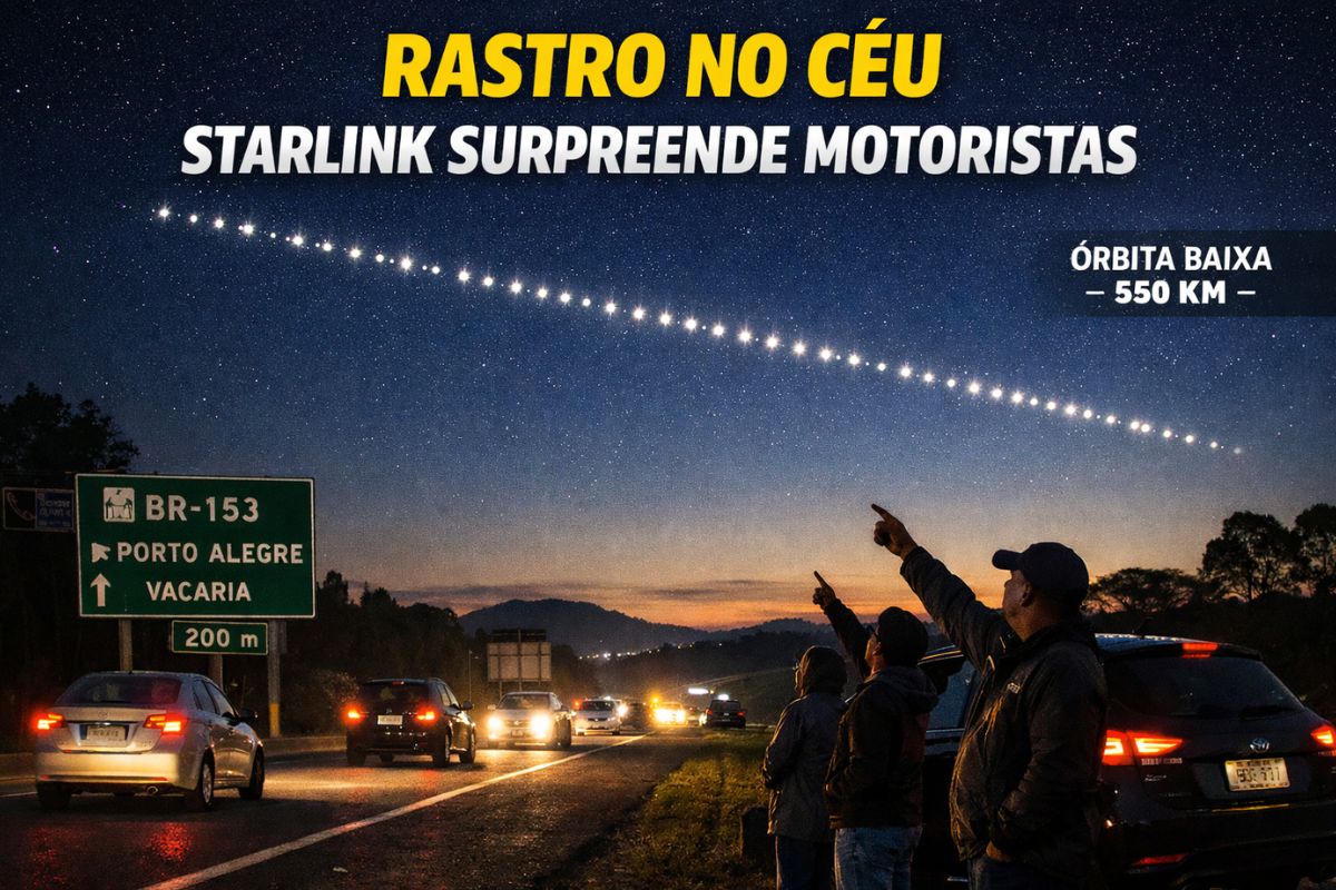


Bright Trail Formed By Starlink Satellites After Launch In California Seen In The Sky In Southern Brazil, Crosses The Region At High Speed And Helps To Explain How Low Orbit Reflects Solar Light Even At Night.
Drivers traveling on the BR-153 highway in General Carneiro and in the regions of Irati and São Miguel do Oeste, on the Santa Catarina side, were surprised on a Thursday night to see a luminous trail cutting through the sky. The scene, which many associated with something mysterious, was actually caused by Starlink satellites recently launched in California by the Falcon 9 rocket, on a mission that departed from Vandenberg Space Force Base.
The explanation, according to the Heller & Jung Observatory, is simple and fascinating at the same time. These Starlink satellites were in low Earth orbit, still very close to each other after the launch, reflecting sunlight and forming a kind of “bright line” visible hundreds of kilometers away, even when, for those on the ground, the sky is already dark.
The Bright Trail That Caught Attention In Southern Brazil
Watch The Video:
-
They seemed like common bones, but scientists were surprised to find a relic over 12,000 years old that dates back to before the Bronze Age.

-
With an almost perfect ring of 70 km visible from space, known as the “Eye of Quebec” and over 100 km in length, the Manicouagan Crater in Canada reveals the colossal mark left by a giant asteroid and has become one of the most impressive formations ever identified on the Earth’s surface.
-
Scientists have found in China dinosaur embryos dating back 190 million years in various stages of development, and the discovery still preserves traces of extremely rare proteins in the bones, something that could change what is known about life before hatching.

-
The CEO of Honor in Spain says that smartphones will change with AI, foldables, and even robot phones; the component crisis is making cheap models more expensive in 2026 and shifting the focus to premium.

The phenomenon observed in southern Brazil began with reports from those driving on the BR-153 and the roads in the Irati and São Miguel do Oeste region. Suddenly, a continuous luminous trail appeared in the sky, advancing rapidly and maintaining an almost perfect alignment.
In videos and photos recorded by residents, it is possible to notice that the Starlink satellites appear as bright points very close together, forming a “train of lights” that crosses the horizon in just a few minutes. For those on the road, the impression is of something completely out of the ordinary, but what is happening is just physics and orbit in action.
This appearance of a bright line occurs shortly after launch because the satellites share the same initial trajectory. Before being spread out into their final orbits, the Starlink satellites follow almost “in line,” which makes the trail even more evident in the night sky.
Why Starlink Satellites Launched In California Appear In Brazil
A common question is how Starlink satellites launched from California can be seen so far away, in another continent. The answer lies in the combination of altitude, speed, and solar illumination.
The satellites do not have their own light. The brightness we see is sunlight reflected off their metallic surfaces and solar panels. Since they are hundreds of kilometers high, they remain illuminated by the sun even after the observed region has entered night. It’s that period when the sky is dark for those on the ground, but up high, the objects are still “seeing” the sun.
In low orbit, like that of the Starlink satellites and the International Space Station, the speed of travel is about 27,000 kilometers per hour. This allows them to cross the sky quickly, being observed in different cities and even in different countries in a matter of minutes. The higher the altitude, the larger the area of the Earth from which the object can be seen, and in some cases, it can be seen from up to 500 kilometers away from its trajectory.
It is this combination of high altitude, high speed, and sunlight hitting the Starlink satellites that allows a launch made in California to create a luminous spectacle for drivers in southern Brazil.
Bright Line, Low Orbit And Solar Light Reflection

Shortly after launch, the Starlink satellites remain close to each other, tied to the same initial orbit. During this phase, they have not yet been distributed in the different positions they will occupy around the planet, which makes them form an almost perfect sequence of bright points.
As they are in low orbit, about 550 kilometers high, these Starlink satellites are relatively close to the Earth. This makes the naked-eye view easier, especially in less illuminated places and at times just after sunset or just before sunrise when the sky is dark for the observer but the satellites still receive direct sunlight.
When the orientation of the solar panels favors reflection, the trail can appear even more intense, as if it were a continuous band crossing the sky. This is the phase in which many videos and photos end up circulating on social media, generating theories and curiosity among those not accustomed to this type of launch.
Starlink Satellites Vs Geostationary Satellites
The Starlink satellites operate in low Earth orbit, at approximately 550 kilometers in altitude. Being so close to the Earth brings two important consequences. The first is visual: they move quickly across the sky and can be seen crossing the horizon in just a few minutes. The second is technical: the shorter the distance, the faster and more stable the internet signal tends to be, as the path the signal travels is shorter.
Geostationary satellites, on the other hand, are stationed about 36,000 kilometers high, always “stationary” above the same point on the planet. They can see almost an entire hemisphere, but they are much farther away, so they do not seem to cross the sky but instead remain fixed in one direction.
In practice, this means that the Starlink satellites are easier to see as moving points in the sky, while geostationary ones require specific observation equipment. Additionally, the lower orbit of the internet satellites in the constellation allows for shorter response times, which is essential for online services.
Internet, Orbit Control And Safety Of Starlink Satellites
Besides creating this striking visual effect, the Starlink satellites have a functional role: providing broadband internet from space. To do this, they need to occupy specific positions in orbit and maintain constant movement, forming a large constellation that covers various regions of the planet.
According to information from the company itself, the Starlink satellites move automatically to avoid collisions with space debris and other objects. They use navigation sensors to adjust trajectory, altitude, and orientation, always seeking the best condition to send the internet signal and maintain safety in orbit.
This active control is important because low orbit is becoming increasingly crowded, with different satellites and rocket fragments. Upon detecting a risk of proximity, the Starlink satellites can perform small maneuvers to reduce the chance of impact, helping to preserve both the constellation itself and other equipment that shares the space around the Earth.
In the end, the bright trail that so many people saw in the sky of southern Brazil is the visible side of a complex system that combines frequent launches, precise orbits, and communication technology to connect distant regions with high-speed signals.
And you, when you see Starlink satellites crossing the sky, feel more curiosity about the science behind the phenomenon or concern about the amount of objects in orbit around the Earth?


Consegui vê alguns subindo aqui de Mato Grosso, há alguns minutos após o pôr do sol.