 Portuguese
  English
  Spanish
Simultaneous movements of Argentina and Brazil expand monitoring in remote and strategic areas, focusing on airspace control in the southernmost region and maritime surveillance of the South Atlantic, essential regions for security, logistics, and national sovereignty.
The surveillance of remote areas has once again gained prominence in the military priorities of the Southern Cone, now with parallel initiatives from Argentina and Brazil aimed at spaces considered critical for sovereignty, logistics, and security.
On one side, the Argentine Air Force has completed the installation of receivers in Patagonia and Antarctica.
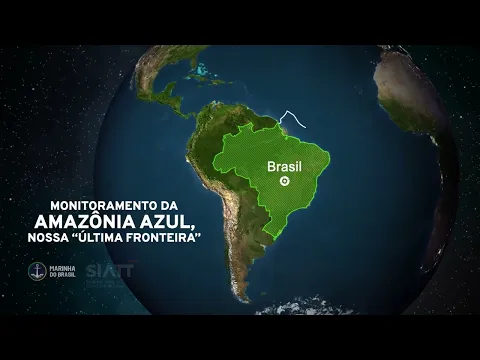
On the other side, the Navy maintains the SisGAAz as the axis of monitoring the Blue Amazon, a maritime area that exceeds 5.7 million square kilometers and concentrates routes, resources, and strategic infrastructure.
-
Goodbye disposable batteries: an item still consumed in 1.2 billion units per year in Brazil has a rechargeable alternative that can be used up to 1,000 times and reduces household expenses.

-
Millions of people have been eating mushrooms for millennia without knowing that this discreet food contains ergothioneine, an antioxidant that scientists now associate with memory protection and healthier aging.

-
Sun Tzu wrote 2,500 years ago that the supreme art of war is to defeat the enemy without fighting, and this phrase from a Chinese general born in 544 B.C. has become the most applied advice in the business world, in conflict psychology, and even in neighborly relations in 2026.

-
With 50,000 people crammed into 3 hectares and buildings stacked like a human anthill, this lawless city that lived without police and oversight reached the highest human density ever recorded in any habitable point on Earth before being erased from the map.

Strategic monitoring in the Southern Cone
The comparison between the two cases reveals different priorities within the same state logic: to expand the capacity to see, record, and react in extensive, remote, and complex oversight areas.
In Argentina, the effort is concentrated in the airspace of the southernmost region.
In Brazil, the emphasis is on the sea, where vital flows for the national economy and the protection of strategic assets pass.
In the Argentine case, the initiative was led by the General Directorate of Research and Development of the Air Force, through the Center for Research and Development of Aeronautical Technologies, the CITeA.
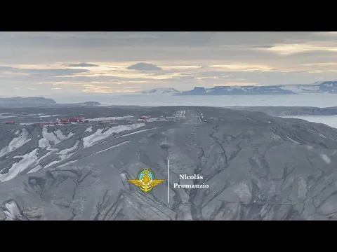
According to the Argentine government, the reception nodes called CITeA Track were installed at the X Air Brigade in Río Gallegos and at the Joint Antarctic Base Marambio, expanding the monitoring of cooperative aircraft in the Patagonian, Antarctic, and Argentine Sea regions.
ADS-B technology and air surveillance in Antarctica
The technological base reported by the Argentine Air Force is the ADS-B, a surveillance system in which the aircraft itself automatically transmits position and identification data.
According to the official note, the solution was designed to provide real-time monitoring, consolidate a unified image of air traffic in areas of interest, and supply both control towers and airspace surveillance and control centers.
Furthermore, according to the same source, the architecture was adapted to severe operational conditions, with protection against strong winds, snow, and extreme temperatures, as well as remote and satellite connectivity.
The Argentine government also describes the arrangement as a low-cost network, capable of expanding coverage without requiring a heavy deployment structure in areas marked by geographical isolation and high logistical demands.
Before the expansion to Río Gallegos and Marambio, the CITeA Track had already undergone operational evaluation at the Military Aviation School and the Río Cuarto Material Area, both in the province of Córdoba.
The Air Force itself reported that these points had been operating for over two years with results considered satisfactory, which helps explain why the installation further south has been presented as an expansion of capacity, rather than as a restricted trial.
Blue Amazon and the weight of the South Atlantic
In Brazil, the institutional response is centered on the maritime environment, where the SisGAAz appears in the Navy’s communications as one of the main tools for monitoring and protecting Brazilian jurisdictional waters.
The structure brings together radars installed on land, aircraft, vessels, high-resolution cameras, and data from collaborative systems, with the aim of forming situational awareness and supporting patrol, oversight, and operational planning.
The dimension of the monitored area helps to understand why the program occupies a strategic position.
The Navy claims that the Blue Amazon exceeds 5.7 million square kilometers, an area where natural resources, offshore energy infrastructure, biodiversity, submarine cables, and essential routes for the flow of national production are found.
In parallel, the naval force maintains that about 95% of Brazilian foreign trade passes through the sea, which makes the surveillance of the South Atlantic a matter of defense, economy, and logistical continuity.
Integrated systems and maritime surveillance
The architecture of the Brazilian system is not limited to direct observation of the coastline.
According to the Navy, the SIMMAP, aimed at supporting oil activities, is already integrated into the SisGAAz.
The LRIT, for the identification and tracking of ships at long distances.
And the PREPS, a satellite tracking program for fishing vessels.
All feed tracking centers through satellite communication.
This arrangement, according to the force itself, tends to gain new technological layers with the anticipated future incorporation of acoustic sensors.
In recent material, the Maritime Operations Command and Protection of the Blue Amazon also indicates the existence of projects related to coastal surveillance of the SisGAAz.
This is a sign that the Navy continues to treat maritime monitoring as a central component of the protection of Brazil’s strategic surroundings.
Distinct priorities in regional defense
Although they stem from distinct geographical realities, the two movements converge in an attempt to reduce shadow areas and decrease dependence on fragmented perception in regions of difficult control.
Argentina seeks to consolidate a reception network aimed at cooperative air traffic in its southernmost region and Antarctica.
Brazil, on the other hand, bets on the integration of sensors and databases to monitor maritime circulation, reinforce oversight, and expand the capacity to respond to illicit activities, environmental incidents, and navigation risks.
These investments tend to attract less public attention than programs associated with fighters, submarines, or large ships.
But they have a direct impact on the state’s capacity for presence.
In practice, they are systems that allow for detecting movements, organizing dispersed information, qualifying decisions, and responding more promptly in environments where distance and low density of means have always favored operational gaps.
The essential difference lies in the object of surveillance and the most immediate strategic problem of each country.
While Buenos Aires seeks to improve the reading of air traffic in a austere and sensitive band from an Antarctic perspective.
Brasília maintains its focus on a maritime area that sustains trade, energy, fishing, communications, and power projection in the South Atlantic.
In both cases, progress does not depend solely on combat platforms. But on the capacity to produce persistent, integrated, and usable information in a timely manner.


Seja o primeiro a reagir!