 Portuguese
  English
  Spanish
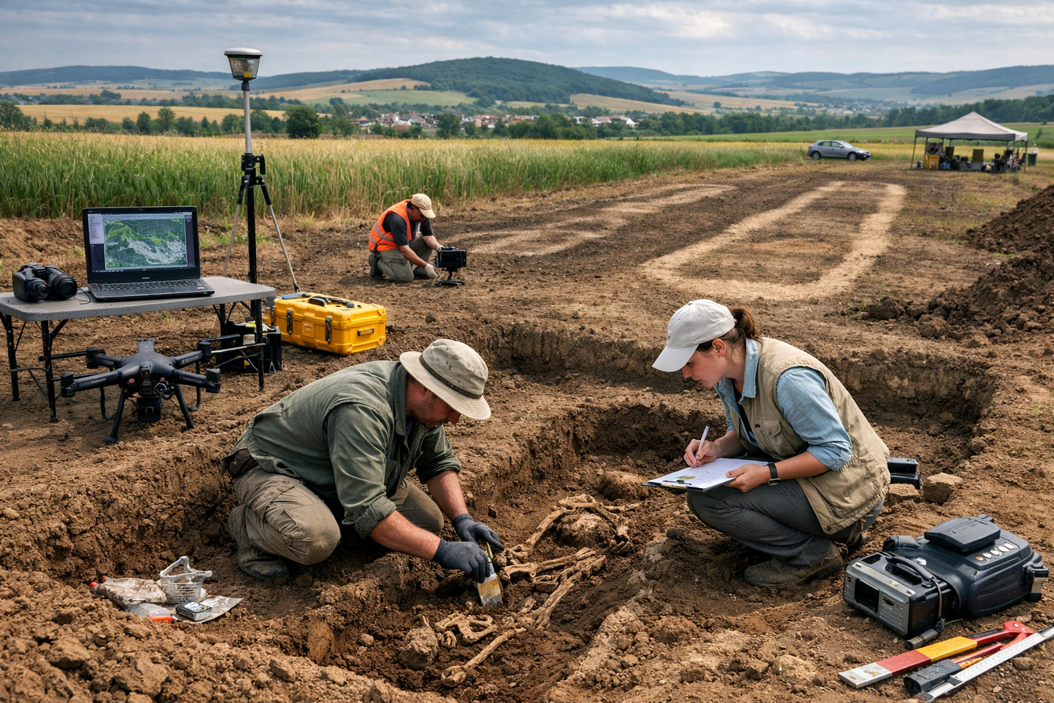
Mapping Technology Revealed Nearly 2,900 Archaeological Remains Buried Beneath Agricultural Fields in the Bohemia Region, Offering a New Understanding of Funeral Rituals and Social Organization of European Neolithic Communities
Archaeologists made a surprising discovery beneath extensive agricultural fields in the Bohemia region of the Czech Republic, identifying hundreds of graves approximately 5,000 years old that remained completely hidden beneath the surface for millennia. The discovery has drawn the attention of the international scientific community as it reveals a complex funerary system from the Neolithic period, dated to around 3000 B.C., offering new clues about the lives and beliefs of ancient agricultural populations in Europe.
Initially, researchers suspected that the area might hide significant archaeological remains. However, for centuries, signs of these structures were erased by intensive agriculture, which completely transformed the landscape. Only now, thanks to advances in modern archaeological mapping technologies, was it possible to accurately identify and document the existence of these ancient funerary monuments.
The information was published by the scientific journal Archaeological Prospection, detailing the study conducted by specialists from the Institute of Archaeology at the University of Wroclaw. According to the researchers, the combined use of various technologies allowed them to reveal an extremely complex archaeological landscape hidden beneath seemingly ordinary agricultural areas.
-
New Zealand builds a shimmering building that vibrates, featuring a 62-seat cinema, moving sculptures, and an environment where sound, light, and energy are felt in the body.

-
Two colored cubes of 2.5 m transform a public bathroom into a selfie spot in Western Australia, costing up to 75% less than traditional construction and helping to reduce vandalism in public spaces.

-
Santa Catarina produces up to 7 times more than it consumes in some sectors, and its century-old industries founded by grandparents and great-grandparents now compete on equal footing with Germany and the United States in the international market.

-
U.S. war giant weighing 9,600 tons and equipped with long-range missiles is sent to the Atlantic to protect global internet and hunt submarines.


Remote Sensing Revealed Nearly 2,900 Archaeological Structures
To achieve this impressive result, the archaeologists used a sophisticated set of technological tools. Among them were high-resolution aerial surveys, airborne laser scanning (LiDAR), and ground magnetometry, techniques capable of identifying invisible changes in the surface and subsurface.
The integration of these methodologies allowed scientists to map approximately 2,900 archaeological remains scattered across the analyzed region. Many of these remains correspond to elongated graves from the Neolithic period, monumental funerary structures used by ancient agricultural communities.
Additionally, oblique aerial images and analyses of soil magnetism revealed details of the internal structure of these 5,000-year-old graves, including burial pits, delineation of ditches, and possible ceremonial areas. These elements remained invisible to the naked eye due to the marks left by modern crops.
Consequently, the application of these technologies demonstrated how the use of remote sensing and archaeological geophysics can radically transform the way researchers investigate ancient landscapes. Even areas apparently destroyed by human activity may still preserve important records of the past.
Graves Functioned as Ritual Centers for Neolithic Communities
Another aspect that caught the scientists’ attention was the symbolic role of these funerary monuments in prehistoric societies. According to information published by the magazine Popular Mechanics, these structures acted as true ritual anchors for Neolithic communities in the region.
The researchers identified clear evidence that populations repeatedly returned to these sacred locations over several centuries. This indicates that the graves were not only burial sites but also centers of collective memory, ceremonies, and religious practices.
Furthermore, archaeological analysis suggests that these monuments were used by successive generations, reinforcing the cultural and spiritual significance of these spaces for agricultural communities of the time.
This behavior reveals a social complexity far greater than previously imagined for the populations of the European Neolithic, demonstrating that these societies had deeply structured ritual traditions.
Separation Between the Living and the Dead Reveals Sophisticated Social Organization
Another fundamental point revealed by the research concerns the spatial organization of ancient Neolithic villages. Surprisingly, studies indicate that the graves were deliberately constructed outside of inhabited areas, creating a symbolic separation between the world of the living and the dead.
The identified funerary monuments were found up to 450 meters away from agricultural settlements, forming a kind of transitional zone between everyday space and sacred space.
This arrangement does not appear to be random. On the contrary, it indicates a planned organization of territory, in which the dead were kept in specific areas of the landscape, possibly associated with spiritual beliefs or community rituals.
Finally, the discovery demonstrates that even regions where modern agriculture seemed to have completely erased traces of the past may still hide true archaeological treasures. The integration of technology, archaeology, and geophysical analysis continues to reveal ancient landscapes that remained invisible for thousands of years.
Thus, the graves of 5,000 years found beneath crops in the Czech Republic not only expand knowledge about the European Neolithic but also show how technological advancement is transforming the way humanity rediscovers its own history.
Source: AH


-

-

-

-

5 pessoas reagiram a isso.