 Portuguese
  English
  Spanish
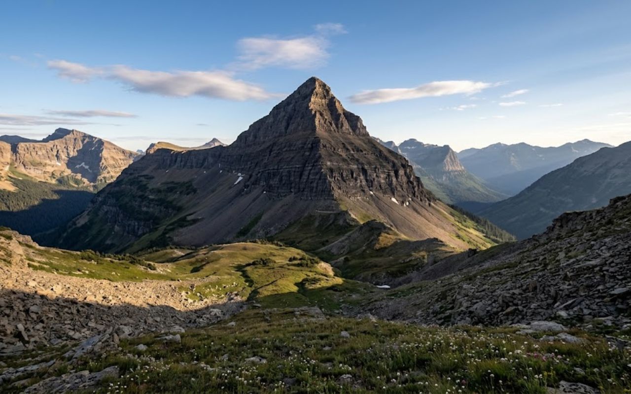
Triple Divide Peak is a unique point in the Rocky Mountains where a drop of rain can flow to three different oceans, revealing a rare geographical phenomenon.
At the top of the Rocky Mountains, in the United States, Triple Divide Peak stands out as one of the rarest geographical points on the planet. Located within Glacier National Park in Montana, this summit attracts attention because a simple drop of rain can take three completely different paths.
The phenomenon occurs due to the convergence of continental divides, which direct water into distinct watersheds. This unique behavior has intrigued scientists, geographers, and explorers for decades, precisely because it practically demonstrates how the terrain shapes the fate of waters.
How does the Triple Divide Peak phenomenon work?
What makes Triple Divide Peak so special is the way it distributes rainwater. Depending on where the drop falls, it enters different river systems that travel thousands of kilometers until they reach the sea.
-
With 75 mutations and confirmed circulation in 23 countries, a subvariant of Covid-19 challenges part of the protection against infection and reinforces the warning about the decline in vaccination.

-
New RG can be delivered by the Post Office in some states, such as São Paulo and Minas Gerais; see how to request it.

-
Homemade mixture of sugar and lemon promises to rejuvenate the skin of the feet, but dermatologists issue a serious warning about the wrong time to use it.

-
He seemed lost, but he got everything right: Charles Ingram “wins” 1 million pounds on Who Wants to Be a Millionaire with a cough code coming from the audience; the production isolates the audio and dismantles the scam.

In practice, the functioning is simple but fascinating. The water can take three main paths:
- In one direction, it flows into the Columbia River and reaches the Pacific Ocean
- In another, it enters the Missouri-Mississippi system, flowing into the Gulf of Mexico, connected to the Atlantic
- Finally, a third route leads to the Saskatchewan basin, which flows to Hudson Bay
Thus, Triple Divide Peak does not merely separate two water flows, as is the case in most mountains, but organizes three distinct continental routes.

Geographical importance
This rare behavior transforms Triple Divide Peak into a true landmark of world geography. It represents a meeting point between major natural divides, responsible for separating watersheds on a continental scale.
Moreover, the site functions as a kind of “natural laboratory.” This is because it allows for a clear understanding of how factors such as altitude, terrain, and slope influence water flow.
Therefore, the peak is not just a curiosity. It also plays a fundamental role in studies of hydrography, cartography, and environmental dynamics.
Formation of the terrain and origin
The structure of Triple Divide Peak is directly linked to the formation of the Rocky Mountains. The summit is part of the Lewis Range, which emerged about 59 to 75 million years ago during intense geological processes.
During this period, large blocks of rock moved along what is known as the Lewis Fault. This movement caused very old rocks to be pushed over younger layers, creating an elevated and complex terrain.
Additionally, the action of glaciers over time helped sculpt the land. This process, known as glacial erosion, was essential in shaping valleys, slopes, and natural divides that today define the behavior of waters at Triple Divide Peak.
Although there are other water divides in the world, few exhibit the same complexity as Triple Divide Peak. This is because most mountains separate only two directions of flow.
In this specific case, however, there are three independent systems operating simultaneously. This characteristic makes the location known as a “hydrological apex,” meaning a maximum point of water division.
Furthermore, its altitude — about 2,446 meters — directly contributes to this phenomenon. The higher the terrain, the greater the capacity to influence the direction of water.
Triple Divide Peak and its relevance
Triple Divide Peak has also gained prominence in educational materials and scientific studies. This is because it offers a didactic way to understand concepts that are often abstract.
For example, by observing this point on the map, it is possible to better understand what watersheds, continental divides, and drainage networks are. These elements are fundamental for understanding the dynamics of water on the planet.
Meanwhile, researchers use the site to deepen analyses on climate, terrain, and water circulation. Thus, the peak continues to be an important reference for different fields of knowledge.
More than a point on the map, Triple Divide Peak symbolizes the power of nature in organizing territory. It clearly shows how a mountain can influence trajectories that cross entire continents.
Thus, each drop of rain that falls there carries a different possibility. And it is precisely this characteristic that transforms Triple Divide Peak into one of the most impressive geographical phenomena on the planet.
With information from Revista Oeste


Seja o primeiro a reagir!