 Portuguese
  English
  Spanish
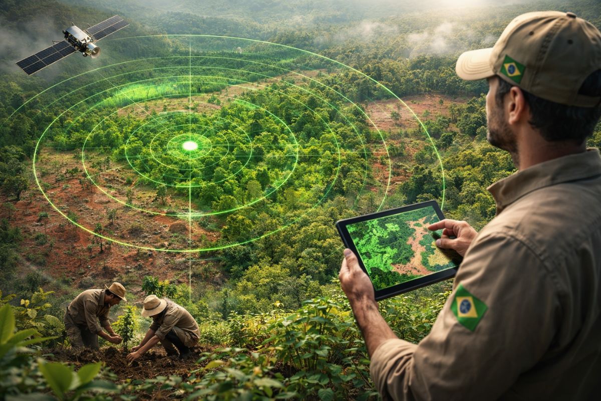


Restoration and Reforestation Observatory Monitors Native Forests by Satellite, Gathers Data from Producers, Companies, and Governments, Reports 90% Increase since 2021, and Details 117 Thousand Hectares in the Atlantic Forest, 19.6 Thousand in the Cerrado, and 14.5 Thousand in the Amazon in Brazil
The native forests have entered a new cycle of visibility in Brazil with the consolidation of the Restoration and Reforestation Observatory (ORR), a platform created to map and identify where ecological restoration is happening and who is doing this recovery in practice, from rural producers to organizations and governments.
The ORR has already identified more than 150 thousand hectares in the restoration process in the country, with an increase of 90% compared to 2021, and opens a detailed map by biomes, municipalities, and initiatives, positioning restoration as a strategic asset linked to climate goals, transparency, jobs, and ecosystem services associated with native forests.
Where Native Forest Restoration is Advancing and What the Numbers Show

The latest data from the ORR shows restoration distributed mainly across three biomes, with a strong concentration in the Atlantic Forest.
-
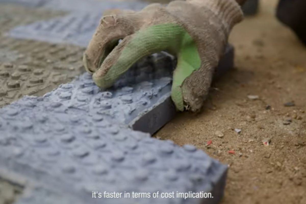
In Kenya, engineer Nzambi Matee created “bricks 2.0” using packaging plastic: a mixture with sand, heated and pressed; they are 5 times more resistant, already have official licensing, and are being used in streets and construction projects.
-
More than 20,000 positions could be opened, and thousands of technicians are starting to be trained in Brazil, as the expansion of data centers creates an urgent race for professionals to keep the internet, cloud, and artificial intelligence running 24 hours a day.

-
China approves the 15th Five-Year Plan 2026-2030 to become a global power: prioritizes brain implants, 6G with AI, humanoid robots, flying cars, quantum technology, and nuclear fusion, while strengthening defense and the economy.

-
HONOR X80i arrives with a massive 7,000 mAh battery, a 120 Hz AMOLED display with a brightness of 6,500 nits, and the new Dimensity 6500 Elite chip, promising up to 22 hours of video playback and impressive performance in casual gaming.


The mapped scale provides a snapshot of the silent progress in degraded areas and positions restoration as a measurable indicator in the national territory.
The presented distribution is as follows
Atlantic Forest with 117 thousand hectares restored
Cerrado with 19.6 thousand hectares
Amazon with 14.5 thousand hectares
The total exceeds 150 thousand hectares, and the growth of 90% compared to 2021 indicates an expansion of registration and monitoring, not only of one type of action but of multiple fronts connected to rural producers, companies, civil society organizations, and governments working with native forests in different landscape contexts.
What is the ORR and How the Green Radar Works in Practice

The Restoration and Reforestation Observatory was created to map and identify restoration in Brazil, gathering information from ongoing initiatives and complementing the country’s portrait with satellite monitoring.
The platform combines data declared by actors who are restoring with a layer of spatial verification, creating a system that allows tracking progress, locating actions, and comparing evolution over time.
The ORR is described as an independent and multi-sectoral platform, launched in 2021, dedicated to mapping the recovery of native vegetation in Brazil.
The focus is to make visible what often remains fragmented in local projects, in addition to enabling more transparent accounting for public policies, private decisions, and climate commitments associated with native forests.
Who Coordinates the Observatory and Which Institutions Support the Project

The coordination of the ORR is linked to the Brazil Coalition on Climate, Forests and Agriculture, through a management group composed of
WRI Brazil
Imazon
WWF Brazil
The Nature Conservancy (TNC) Brazil
The structure is made in partnership with restoration movements and a technical group, which enhances the capacity for outreach, collection, and qualification of information.
This institutional configuration is a central element of the “green radar” because it combines multi-sectoral governance with technical monitoring capacity, something crucial to give consistency to data on native forests restored.
Two Interfaces and Two Audiences: Technical for Analysis and Public for Decision
The platform offers two main interfaces, with different but complementary objectives.
The first, more technical, allows visualization of data on a map of Brazil and performing detailed spatial analyses.
This layer facilitates the accounting of advances and increases transparency about the evolution of restoration, helping to answer questions such as where restoration is concentrated, how it is distributed, and how it changes over time.
The second interface presents key data in a compiled format, aimed at public and private managers, researchers, and civil society, allowing informed decisions.
Companies can give visibility to their restored areas, and the financial sector can track actions linked to ESG, connecting the agenda of native forests to a risk, impact, and opportunity reading.
Restoration, Reforestation, and Secondary Vegetation: What the ORR Separates and Why
To organize the country, the ORR classifies recovery efforts into three major groups. The separation is important because each category has different dynamics, objectives, and implications.
Restoration is defined as the process of aiding the re-establishment of a degraded, damaged, or destroyed ecosystem, focusing on the recovery of native vegetation and associated ecological functions.
Reforestation is defined as the planting and cultivation of trees for forestry activities, whether of exotic species such as pine and eucalyptus, or through the forestry of native species.
Secondary vegetation is described as natural regeneration without anthropogenic intervention after clear-cutting, burning, or use for agriculture or pasture.
Within the environmental debate, this distinction completely changes the interpretation of the numbers because “planting trees” can mean very different things.
The ORR places native forests at the center when discussing ecological restoration and also when discussing natural regeneration with guaranteed permanence.
Natural Regeneration as a Scale for Native Forests and the Role of Interventions
One of the strategic points described is the natural regeneration conducted from interventions that ensure the permanence of native vegetation.
In this format, secondary vegetation can become a crucial tool to scale restoration in the country because it leverages the ecosystem’s recovery capacity.
The logic is to transform what arises spontaneously into a long-term trajectory, avoiding setbacks due to new land use pressures.
This approach reinforces restoration as a policy and as a continuity investment, not just as a one-off action, keeping native forests standing and in recovery.
Why Visibility Becomes Money, Jobs, and Acceleration of Restoration
The ORR has a characteristic described as decisive: to give visibility to those who restore at the grassroots level.
Producers and organizations that carry out restoration receive recognition and transparency, a step that tends to unlock access to necessary resources and financing to accelerate and increase the scale of restoration.
The data reinforces restoration as an activity capable of generating jobs, ensuring more sustainable agriculture, and helping the country to meet climate commitments.
The mentioned commitment includes the goal of restoring 12 million hectares by 2030, established in the Paris Agreement, positioning the restoration of native forests as a strategic environmental infrastructure.
Biomatic Collectives and Outreach: Who Helped Build the Map
The gathering of information was described as dependent on the role of restoration movements, producers, companies, governments, civil society organizations, and research institutions.
The mentioned biometric collectives contributed significantly to the transparency effort, including
Pact for the Restoration of the Atlantic Forest
Network for the Restoration of the Caatinga
Pact for the Restoration of the Pantanal
Articulation for the Restoration of the Cerrado (Araticum)
Alliance for the Restoration of the Amazon
Southern Network
The existence of these collectives shows that the “green radar” is not just satellite and map, but also a network of articulation that allows the ORR to gain outreach and increase its capacity to report on progress in Brazil, connecting local initiatives to the national portrait of native forests.
Search by Municipality and Examples of Traceable Public Policies
A relevant resource of the ORR is allowing searches by municipality, making it possible to identify where restoration is happening, not just the total aggregated by biome.
This transforms the platform into a tool for public policies, social oversight, and prioritizing investment.
Among cited examples of public actions with visibility are the work of the city hall of Extrema (MG) and the Conservator of Mantiqueira program, in addition to the incorporation of state databases.
This type of municipal cut makes a difference because it shows restoration as a concrete territorial action and not as an abstract promise, with direct effects on native forests.
Carbon Credits, Environmental Compensation, and Interest from the Private Sector
Corporate adherence to the sector is described as motivated by reasons such as the commercialization of carbon credits and environmental compensation.
At the same time, the participation of national and international banks in financing the activity places the issue in a zone where environmental and economic intersect, with restoration becoming an asset in the climate agenda.
The platform, by giving visibility and allowing monitoring, creates an informational infrastructure for restoration and recovery actions of native forests to be tracked with more rigor, which tends to impact investment decisions and corporate commitments linked to ESG.
A Continuous, Legally Careful, and Collaborative Effort
In the last three years, the ORR has dedicated itself to qualifying the data compiled in the first version of the tool, adapting to legal issues regarding data, collecting new information, and establishing partnerships with biometric collectives. This indicates a maturation effort, seeking robustness and informational security.
The platform is described as dynamic, continually seeking new data and improving information, which depends on ongoing engagement with rural producers, companies, civil society organizations, and public managers.
The declared objective is to consolidate Brazil as a global leader in mobilizing information and taking effective action on the restoration agenda, protecting biodiversity and promoting a more sustainable future with native forests in recovery.
What do you think is more decisive for accelerating the recovery of native forests in Brazil, private financing, municipal policies, or satellite monitoring that provides transparency to the national map?


👏👏👏👏👏👏👏👏👏