 Portuguese
  English
  Spanish
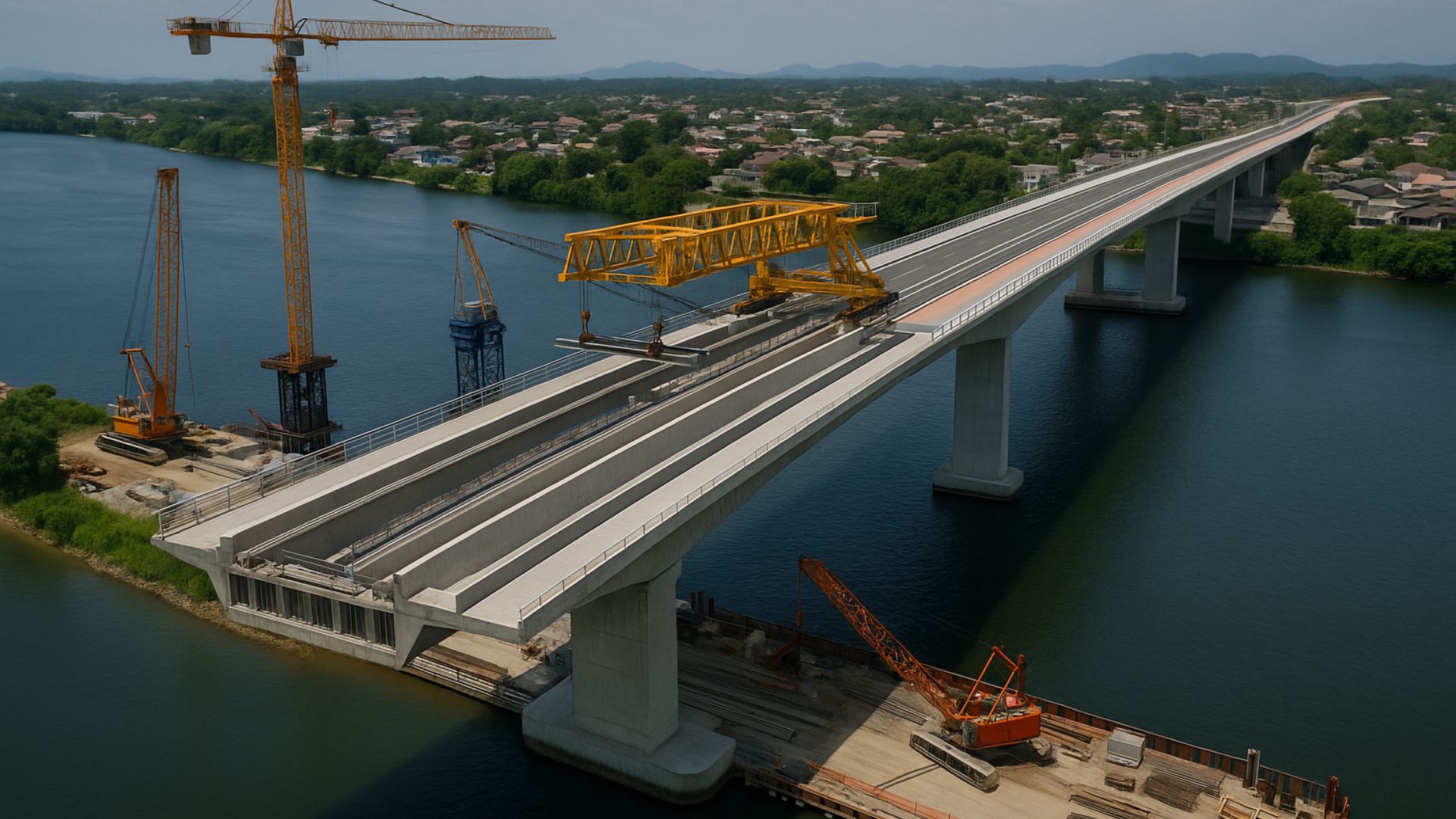


Connection over the Cachoeira River Advances With Works, Alters Traditional Routes in Joinville, and Raises Expectations in Mobility and Regional Logistics.
The Joinville Bridge, under construction over the Cachoeira River, is expected to reduce the crossing between the South and East zones of Joinville from about 45 to 10 minutes.
The expectation is to decrease traffic in the center and increase the capacity for movement in one of the main corridors of the city.
With an updated investment of R$ 328 million and an expected completion between January and February 2027, the new connection is considered by municipal managers as a key structure to serve thousands of residents and facilitate access to services and industrial areas.
-
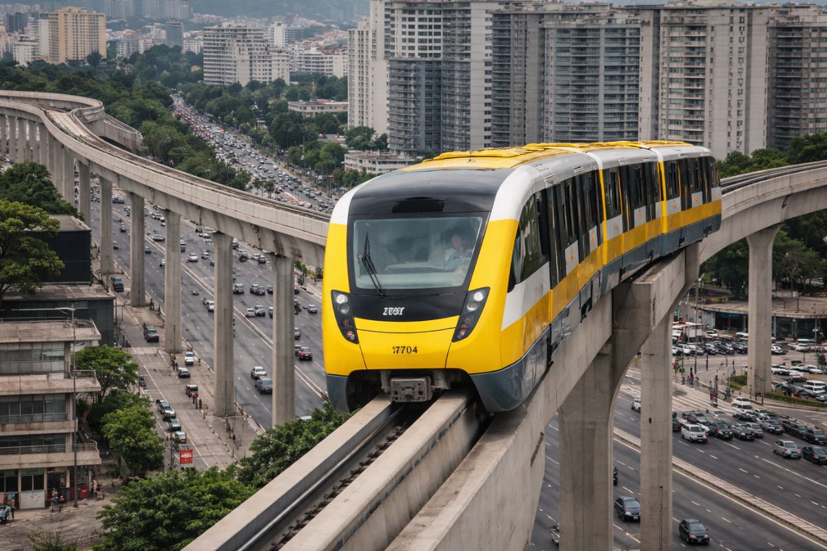
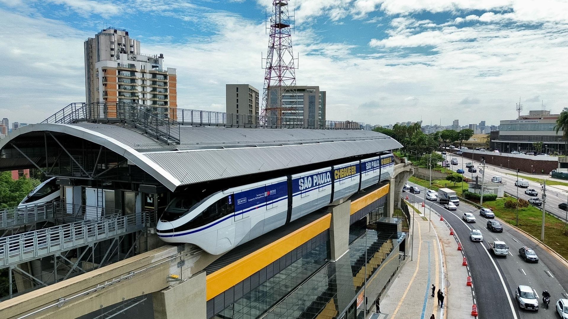
The project that was supposed to be ready for the 2014 World Cup in Brazil debuted with a 12-year delay and nearly R$ 6 billion invested: the Line 17-Gold of the São Paulo monorail opened with reduced hours and is only expected to operate fully in October.
-
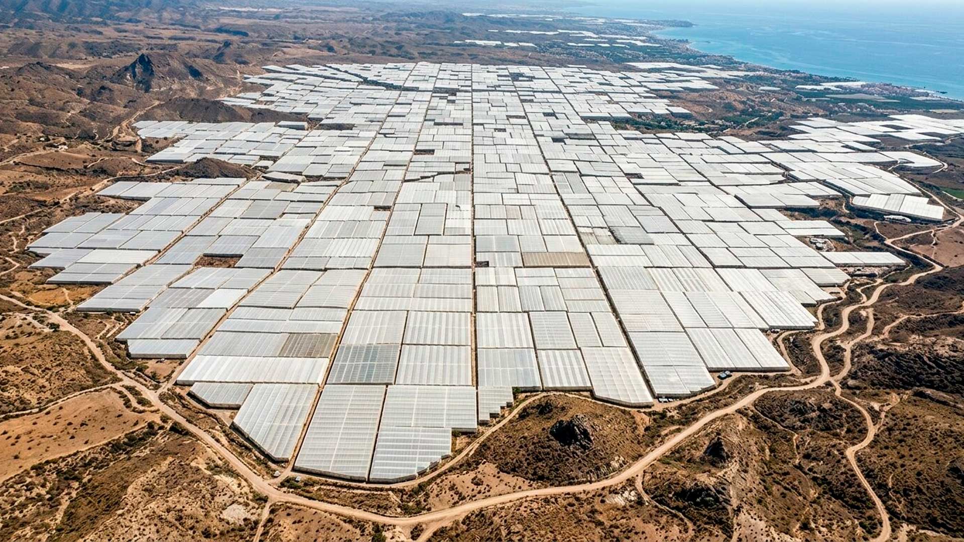
Neither the Pyramids nor the Great Wall of China, this gigantic construction in Spain is the human mark on planet Earth that intrigues the most when seen in images from space.
-
Surrounded by cliffs, mist, and chilling stories, the ancient Hotel del Salto has been reborn as a museum while still unable to shake off its reputation as a haunted place.

-
This star-shaped fortified construction, hidden near the border of Spain, may be the largest fortress on the planet.


Joinville Bridge Works and Structural Advancement
The project advances the direct link between the neighborhoods of Adhemar Garcia and Boa Vista, with 980 meters in length and 26 meters in width.
The alignment starts from Alwino Hansen Avenue, crosses the Cachoeira River, and connects to São Leopoldo and São Borja streets, forming a new road axis between the South and East regions.
The execution is by Álya Construtora S/A, supervised by the Nova Engevix – Azimute Consortium.
The project foresees two lanes in each direction, shoulders, continuous bike lanes, and sidewalks.
Estimates from the municipality indicate a direct benefit for approximately 448 thousand residents.
The service order was signed on May 23, 2024.
The international financing includes US$ 40 million from Fonplata, complemented by municipal resources.
The project has Environmental Installation License 5.183/2022, issued by the Environmental Institute.
The structure uses 32 thousand cubic meters of concrete and 2 thousand tons of steel, maintaining a navigable channel of 80 meters in width and 9.5 meters in height.
Engineering and Execution Stages

Currently, about 30% of the contract has been financially executed.
The teams are working on the foundations and the mesostructure, a phase expected to last until January 2025.
Two cantilever cranes of 350 tons operate on platforms measuring 12 by 15 meters, with cranes of 160 tons.
The metal piles can reach a depth of 40 meters.
In total, there will be 240 piles, with 192 in Adhemar Garcia and 48 in Boa Vista.
The first was driven in August 2024.
By June 2025, the structural advancement had reached about 320 meters towards the riverbed.
The transition slab connecting the avenue to the bridge began to be poured in October 2025 in Adhemar Garcia.
In Boa Vista, the slab on São Borja Street is completed.
Technicians assert that the division into two simultaneous poles accelerates the schedule.
During peak times, 500 workers are expected to be on site.
Currently, about 50 professionals are participating in the foundations.
The precast beams are manufactured in yards in Adhemar Garcia and Comasa, transported via temporary bridges.
The piles amount to 3.3 kilometers of excavations, with parts of up to 210 tons.
Technical reports indicate that unstable soils and mangrove areas require deep foundations and careful logistical planning.
The licensing requires the preservation of riparian vegetation and environmental monitoring by IMA.
Urban Traffic and Flow Between South and East Zones
Movement between South and East relies on roads that cross the center, such as Rua do Príncipe and Avenida Beira-Rio.
According to the municipality, these corridors register delays of up to 45 minutes and serve about 50 thousand vehicles per day.
Mobility specialists consulted by the city assert that the bridge will function as a “traffic redistribution axis,” reducing demand on the center.
The connection is expected to shorten routes for lines serving four bus terminals, including Central and South.
Data from the Infrastructure Secretariat indicates that residents travel up to 15 additional kilometers to access the industrial hub in the South zone.
This extra time alters transportation costs and daily routines.

Students who cross the center report an average of 30 additional minutes per trip.
The municipality estimates a reduction with the new route.
Access to Essential Services and Active Mobility
The expected crossing time of about 10 minutes should facilitate access to Hospital São José, schools, and nearby neighborhoods.
Municipal technicians state that health, security, and assistance services could also gain speed.
The bridge will feature a 980-meter bike lane, anti-slip flooring, and accessible sidewalks, following ABNT NBR 9050.
Urban planners involved in the project believe that the infrastructure could encourage non-motorized travel in a city of approximately 600 thousand inhabitants.
Conditions of the Cachoeira River and Environmental Monitoring
The Cachoeira River presents a Water Quality Index ranging from “poor” to “fair”, according to measurements from environmental agencies.
The fluctuations are due to the presence of domestic and industrial wastewater.
Municipal and state reports indicate gradual improvement following expansions in the sewer system, although critical areas remain.
The sanitation plan foresees progressive advancements in the coming years.
During the construction, there is monitoring of sediments, waste control, and compensations determined by IMA.
Economic Impact and Regional Logistics
Joinville is recognized as the largest industrial hub in Santa Catarina.
Industries such as metallurgy, textiles, plastics, automotive, and technology have a strong presence in the South and East zones.
Logistics consultants claim that more direct routes could reduce truck travel time by up to 35 minutes.
The connection with the port complex of Itajaí and Navegantes, which handled around 1.28 million TEUs in 2024, is considered an important factor for regional drainage.
Representatives from Fiesc note that improvements in traffic and access to BR-101 influence operational costs of fleets.
The bridge adds to the duplication of sections of the highway and work at Aeroporto Lauro Carneiro de Loyola, with flights to São Paulo and Porto Alegre.
Investments in Mobility in North Catarina

The project is part of a R$ 650 million mobility package in the North region.
Among the interventions is the Bridge Anêmonas, expected to serve 114 thousand people with an investment of R$ 25.9 million.
Joinville ranks among the cities with the highest GDP in Santa Catarina, with a per capita GDP above the state average, according to IBGE.
Experts say that road infrastructure influences industrial expansion decisions, although the effects depend on variables such as logistical cost, energy, and labor.
Some projections about industrial growth still lack sufficient statistical consolidation for confirmation.
Bidding, Additives, and Next Construction Milestones
The bidding was approved in 2024, following a failed attempt in 2023.
The initial contract was for R$ 296 million and received additives in 2024 and 2025, reaching R$ 328 million.
The next phase involves the installation of beams, slabs, paving, signage, and urbanization of the surrounding area.
With the progress of the project, a practical question arises for those circulating in the city: which impact will tend to be more perceptible in daily life, the reduction in travel time or the increase in productive capacity in the South and East regions?


Obrigado presidente Bolsonaro 🇧🇷🙌
Olá
Feito