 Portuguese
  English
  Spanish
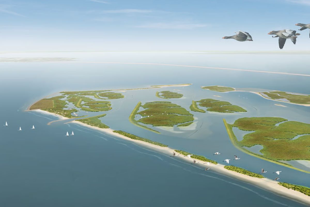
In Markermeer, the islands created by Natuurmonumenten, Rijkswaterstaat, and Boskalis use sediments extracted from the bottom to reconstruct shallow areas, banks, and flooded areas, reduce chronic turbidity that arose after the dam in 1976, and demonstrate that the accumulated sludge can sustain long-term hydraulic restoration on a large scale throughout the region.
The islands built in Markermeer, in the Netherlands, arise from an unusual logic: instead of removing the accumulated sludge merely as waste, the project transforms this material into raw material to redesign a 700 km² lake that lost natural banks, accumulated fine sediments, and began to coexist with persistent turbidity. The operation brings together Natuurmonumenten, Rijkswaterstaat, and Boskalis in an intervention that combines dredging, land modeling, and hydraulic engineering.
The central point is not just to raise new landforms within the water. The bet is to use the islands as a physical tool for reorganizing the lake, retaining sludge, reconstructing edges, creating shallow zones, and testing whether the accumulated mass of sediments over decades can correct some of the imbalances created by previous dams, dikes, and containment works.
How Markermeer Became a Lake Stuck with Sediments and Turbid Water

Markermeer was separated from IJsselmeer in 1976 when the dam between Enkhuizen and Lelystad was completed. Before that, both were part of the old Zuiderzee, a North Sea inlet dammed in 1932. This sequence of interventions completely redefined water circulation.
-
Scientists transform sawdust into fire-resistant panels, stabilize the compound with an enzyme extracted from watermelon seeds, and turn waste into promising material for construction.

-
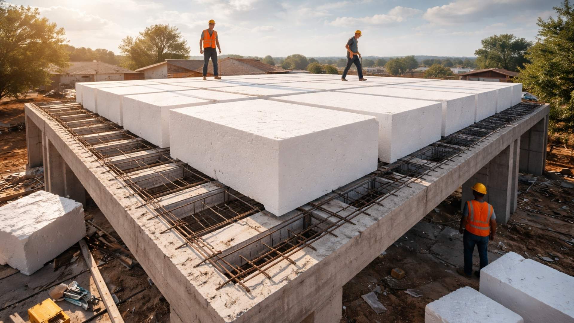
Forget concrete: architects are replacing tons of concrete with giant blocks of expanded polystyrene to build the roofs of houses and reduce structural weight by up to 50%, cut costs, improve thermal insulation, and speed up construction.
-
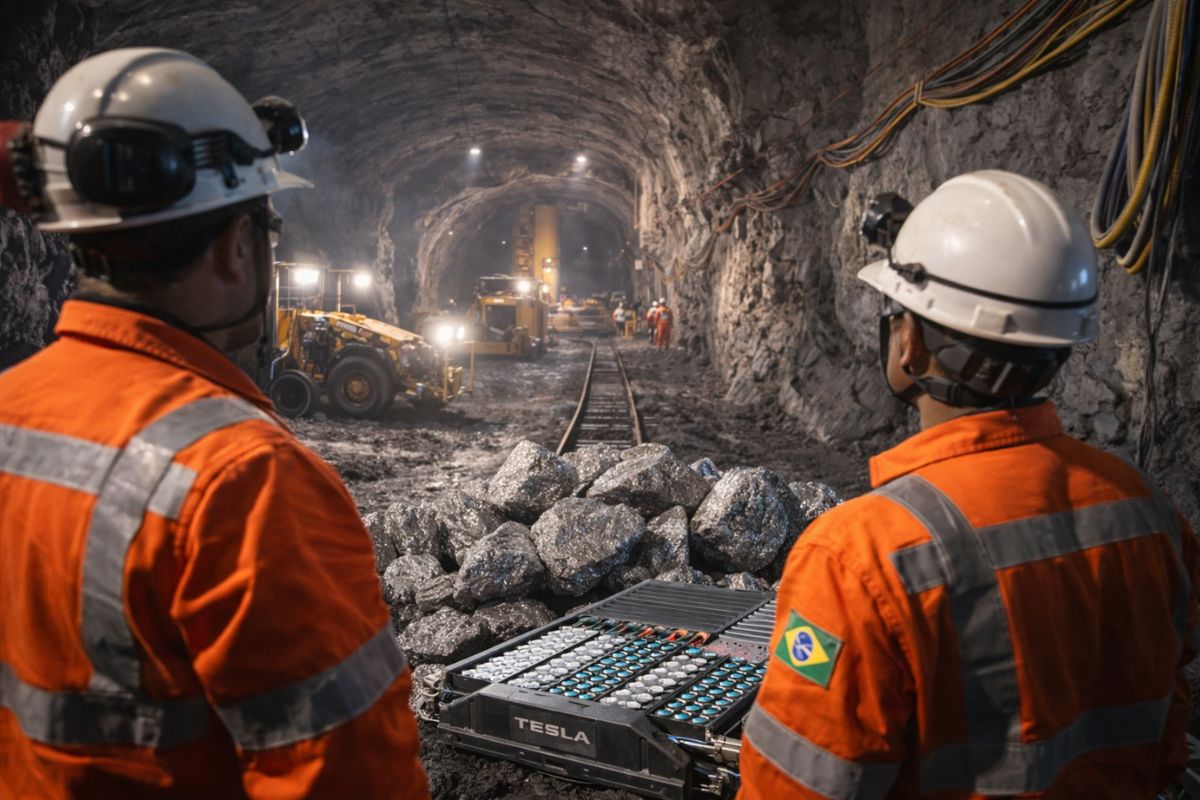
The Brazilian state enters the center of the global race for critical minerals by starting the construction of the largest underground nickel mine in Latin America, a mineral essential for electric car batteries that the entire world is competing for at this moment.
-
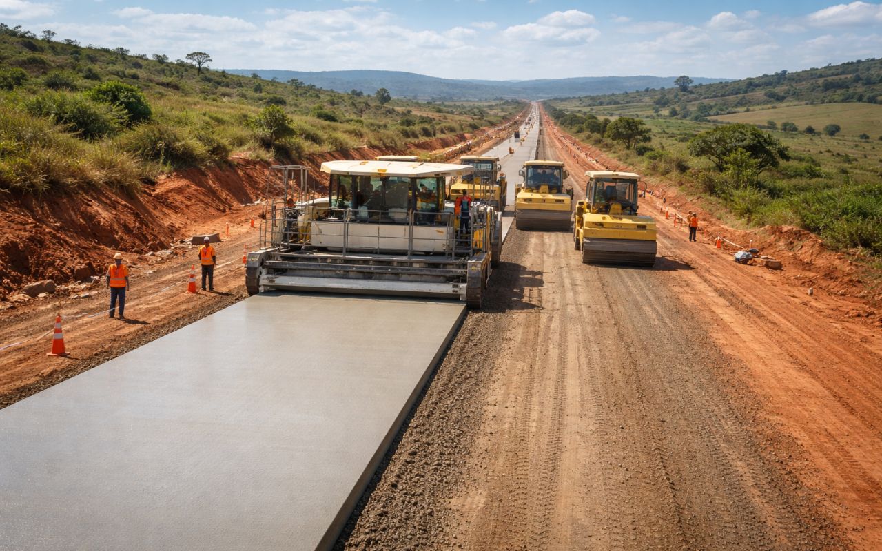
New CCR concrete paving technology promises roads up to 3x more durable, less maintenance, and cost reduction in Brazil.

What previously exchanged with larger systems began to function as a more closed body, reliant on internal balance and with less capacity to expel fine material.
With a relatively shallow depth, between 2 and 4 meters, the lake became especially vulnerable to resuspension. Wind and waves easily stir the material deposited on the bottom, returning particles to the water column and increasing turbidity.
At the same time, Markermeer lost much of its natural banks due to landfill and flood protection measures.
The result was an increasingly rigid water system at the edge and increasingly unstable at the bottom.
This accumulation did not happen by chance. For years, there was an expectation to transform the area into a polder, but the plan was postponed until it was abandoned in 2006.
When that occurred, the lake had already been isolated from IJsselmeer for more than three decades. In the meantime, the lack of efficient drainage for the fines accelerated the formation of a thick layer of sludge.
From then on, the erosion of the remaining banks and repeated turbidity ceased to be separate problems and began to operate as a single physical blockage.
Why the Islands Were Designed with the Sludge from the Lake Itself

The chosen technical solution was to build islands with sand, clay, and dredged sludge from Markermeer itself.
Instead of seeking external material on a large scale, the project is based on the idea that the sediments accumulated in the lake can be repositioned to solve two issues at once: the excess dispersed sludge in the system and the lack of structures capable of interrupting wave energy in strategic areas.
In practice, the islands function as a planned geomorphological reorganization. When installed with natural banks, shallow zones, and flooded sections, they create more protected sides, where the sediments in suspension tend to settle.
This directly addresses turbidity, not through mechanical filtration, but through reconfiguration of space and the local particle transport regime.
What previously circulated uncontrollably now encounters physical barriers capable of slowing down that movement.
The project also explores natural processes of flow and gravity. Near the location of the first island, a deep channel was planned to concentrate large quantities of fine material.
This retained material would then be used to form the new structures.
The engineering acts less as a force of imposition and more as a force of direction, choosing where the lake should accumulate, where it should stabilize, and where the new edges should take shape over time.
Who Executes the Work and What Is the Real Size of the Intervention
The initiative was launched by Natuurmonumenten in partnership with Rijkswaterstaat, the executive agency of the Ministry of Infrastructure and Water Management of the Netherlands. After the bidding process, Boskalis was selected to carry out the work.
The Marker Wadden project was conceived in phases, but it was born on an unusual scale: the declared ambition is to restore an area of up to 100 square kilometers within Markermeer.
The first phase foresees the construction of seven islands, totaling 1,300 hectares, in addition to shallow and deep channels and new marginal strips.
The cost of this phase was estimated at 90 million euros. The main funding came from Natuurmonumenten itself, the Netherlands National Postcode Lottery, the Ministry of Infrastructure and Water Management, the Ministry of Agriculture, Nature and Food Quality, and the provinces of Flevoland and North Holland.
Preliminary works began in the spring of 2016. The schedule indicated completion of the first five islands in 2021 and the sixth and seventh in 2023.
The first island was installed about four kilometers from the dam between Enkhuizen and Lelystad, a distance chosen to preserve the open horizon reading of Markermeer.
Even the position of the islands was treated as a technical decision, not just for construction fitting but to maintain the visual and spatial relationship of the lake with its edges.
What the New Banks Try to Correct in the Water and the Lake’s Shape

The intervention does not merely create isolated pieces of land. The objective is to reconstruct banks, shallow zones, and flooded areas that have practically disappeared from the lake after decades of containment works.
In doing so, the project attempts to return physical complexity to a system that has become overly simplified: rigid edges, silted bottom, and frequently opaque water.
The islands enter as a device for redistributing hydraulic space.
This redesign aims to reduce the energy that keeps the sludge in constant motion. In areas protected by the new edges, the sediments tend to settle more stably, helping to lower turbidity and improve the reading of the bottom and banks.
At the same time, the reconstruction of these transitions between land and water combats the homogenization produced by decades of defensive engineering, which favored dikes and landfill but eliminated intermediate gradients.
There is also a dimension of human use and controlled occupation. The port island was designed to accommodate docks for boats, sandy beach, discreet pavilion, four holiday homes, and research and management structures.
The ensemble was designed to generate its own energy, potable water, and wastewater treatment.
The idea is for the infrastructure not to be an afterthought but part of the experiment from the start, showing that the physical restoration of the lake and public use can be planned in the same design.
Why Marker Wadden Became a Showcase of Dutch Hydraulic Engineering
The project has been described as one of the largest freshwater environment restoration undertakings in Western Europe and, at the same time, as a showcase of Dutch hydraulic engineering. This is because Marker Wadden does not rely solely on construction volume but on methodology.
The central expression is “building with nature,” understood here as the use of transport, deposition, and accommodation processes of sediments to solve water, bank, and visibility issues.
This method is of interest beyond Markermeer because it combines three fronts that are often seen separately in other works. The first is erosion control.
The second is the reduction of turbidity. The third is the management of accumulated bottom material, which usually requires costly disposal or permanent removal.
By transforming sludge into structure, the project attempts to prove that a lake’s liability can transform into engineering’s asset.
There is also an economic and institutional argument. Innovative techniques were chosen to keep costs as low as possible while creating an exportable demonstration of the Dutch experience in flood protection, water quality improvement, and sediment management.
If the arrangement works in the long term, Marker Wadden ceases to be just a local case and becomes a model for regions facing shallow lakes, degraded banks, and persistent erosion over large surfaces of inland water.
Ultimately, what is being tested in Markermeer is an inversion of reasoning. For a long time, the accumulated sludge was treated only as a sign of deterioration. Now, it is repositioned as a project input.
The islands synthesize this change: they emerge from dredging, reorganize the water, redesign the shores, and attempt to prove that the physical recovery of a lake can begin precisely with the material that seemed to condemn it to being stuck.


-

-

-

-

-

-

13 pessoas reagiram a isso.