 Portuguese
  English
  Spanish
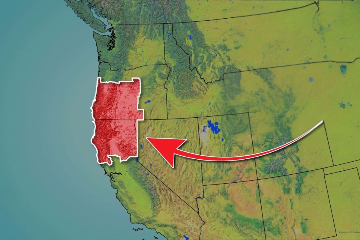


On The West Coast Of The USA More Than Fifty Million Live In Poles Like San Diego Los Angeles San Francisco Sacramento Portland And Seattle But The Central Section Between Northern California And Southern Oregon Remains Almost Empty Due To A Rare Combination Of Relief Logistics Smaller Rivers And Difficult Coast
The West Coast of the USA is home to some of the largest urban centers in the country, with San Diego, Los Angeles, San Francisco, and Sacramento to the south, and Portland and Seattle to the north. Even so, a vast strip between Northern California and Southern Oregon remains very lightly populated, despite landscapes of high environmental value and tourism potential.
The explanation for this contrast is not due to a lack of visual attractiveness, but rather to a series of geographical and historical factors that limited large-scale agriculture, ports, major transportation corridors, and consequently, the formation of metropolises in the heart of the West Coast of the USA.
The Empty Strip Between The Great Poles Of The Pacific

When many people think of the West Coast of the USA, they often remember the high technology in the Bay Area and in Seattle, the beaches, and the entertainment industry in Southern California, as well as the urban profile of Portland. Between these poles, there is a large territorial strip that connects Northern California and Southern Oregon, often associated with the name Jefferson State.
-
Luciano Hang revealed that Havan’s air fleet has already accumulated more than 20,000 landings, 10,000 flight hours, and 6 million kilometers traveled, and he says that without the planes, the company would never have grown so quickly.

-
A historical discovery in the Andes Mountains reveals a gold deposit valued at 770 billion reais hidden over 4,000 meters above sea level on the border between Chile and Argentina, and the whole world is watching.
-
With just joint compound, white glue, and pigment, you can make a homemade paint that yields double the conventional amount, saves up to 70%, and leaves the wall with a finish that no one would believe wasn’t store-bought paint.

-
Home environment can influence the brain, mood, and well-being: studies indicate an increase of up to 15% in productivity, a reduction of 12% in stress with plants, and a direct impact of the circadian rhythm on the 24 hours of the day.


The highlighted general data is that the West Coast of the USA is home to more than fifty million people, while California, to the south of this strip, has more than forty million inhabitants. To the north, Portland and Seattle serve as urban anchors of the Pacific Northwest. In the middle, the density drops sharply, creating a region that appears as “almost empty” on a national scale.
Rough Beauty, Giant Forests, And Mountains Dominating The Terrain

The coastline of California is described as a coast of rough beauty, with rocky cliffs, golden beaches, and marine ecosystems. On land, forest presence is dominant: Tahoe National Forest, Trinity National Forest, and Six Rivers National Forest are examples of large protected areas associated with ancient and very tall trees.
Above the forests, geography changes levels with the meeting of mountain ranges. The southern end of the Cascade Range and the northernmost part of the Sierra Nevada help shape a difficult terrain environment, where valleys are limited and altitude transitions are rapid, factors that increase the cost of urban occupation and infrastructure.
In this context, a physical landmark emerges that synthesizes local uniqueness: Mount Shasta, at 14,179 feet elevation. The United States Geological Survey monitors the volcanic activity of the mountain and the classification cited is of a high-intensity eruption threat, adding an element of geological risk to the regional equation of the West Coast of the USA.
Southern Oregon: Cut Coast, Rogue Valley, And A Unique Biosphere

Southern Oregon is presented as less known and less populated than the northern portion of the state, but with geographical richness. The coastline alternates sandy beaches, rocky formations at sea, and ocean cliffs, reinforcing the rugged coastline pattern.
Inland, the Rogue Valley stands out as a fertile exception, with agriculture and a wine industry described as prosperous. The climatic highlight is a warm and dry pattern compared to northern Oregon, associated with a unique biosphere. Still, the general reading is that these fertile pockets are relatively small to sustain the level of urbanization observed in other parts of the West Coast of the USA.
Crater Lake And The Deep Mark Of Geological Past
One of the most emblematic elements of Southern Oregon is Crater Lake, located in the Cascade Mountains. It is described as the deepest lake in the United States and the second deepest in North America.
The origin is also geological and dated: the lake is said to have been formed by the collapse of Mount Mazama about 7,700 years ago. This type of formation reinforces how the territory was shaped by high-energy events, with direct consequences for the relief, access, and human occupation in the central strip of the West Coast of the USA.
The Great Basin And The “Empty West” As A Natural Border
To the east, the transition between coast and interior is marked by the Great Basin, a desert landscape with its own flora and fauna. The contrast is explicit: this environment is more similar to Nevada than to the coastal and forested areas of southern Oregon and northern California.
The presence of desert alongside mountains and forests creates a difficult mosaic for large population centers. Instead of a continuous corridor of plains and navigable rivers, there are natural barriers in sequence, which helps to understand why the central strip of the West Coast of the USA did not replicate the growth of the northern and southern extremes.
The Historical Path Of Occupation: Why Other Routes Prevailed
In the early 19th century, the United States was still mostly concentrated in the east of the continent. The expansion westward gained momentum with the acquisition of Louisiana in 1803, which added 828,000 square miles to the territory and stimulated exploration and reports on the potential of the new areas.
The migration was driven by specific routes and advantages. Colonizers headed to the Willamette Valley, in present-day Oregon, via the Oregon Trail, described as a wagon route of over 3,000 kilometers, connecting Missouri to Oregon. Between 1841 and 1869, more than 400,000 colonists, miners, farmers, and ranchers used this path.
A decisive factor was geological and prior to modern occupation: the Missoula Floods, associated with the breaking of a large glacial dam, repeatedly flooded eastern Washington and the Willamette Valley, depositing sediments and forming very fertile soil. With the Columbia River running along the valley, it became easier to cultivate and transport agricultural products.
To the south, another economic magnet was at play. The California gold rush in 1848 brought around 300,000 people to Northern California, drastically altering the demographics. A symbolic data point in this acceleration appears in San Francisco, which is said to have gone from a settlement of 200 inhabitants in 1846 to a city of 36,000 in 1852.
The national infrastructure consolidated the shift with the Transcontinental Railroad, built between 1863 and 1869, connecting the eastern rail network to the Pacific in San Francisco. Additionally, the Homestead Act of 1862 encouraged migration by offering 160 acres of virtually free public land, provided a house was built and cultivation occurred. The reported outcome is the distribution of 270 million acres by 1934, primarily in the western states.
Even with successive waves of migration, the central reading is objective: the intermediate strip of the West Coast of the USA “had nothing to offer” on a comparable scale when measured by large ports, larger rivers, and extensive fertile plains, leading to a growth described as anemic compared to the northern and southern neighbors.
Difficult Infrastructure: Mountains, Few Large Rivers, And A Little-Port Coast
The formation of large-scale human settlements usually depends on fertile land and naturally favorable points for navigation and exchange. In the central strip of the West Coast of the USA, these factors appear to be limited.
Outside the Sacramento Valley, the region is described as very mountainous. Between the Sierra Nevada and Cascade, there are few low plains suitable for large cities. Where valleys exist, such as the Rogue Valley, they are considered small and have limitations for establishing transportation infrastructure associated with large ports.
The hydraulic contrast is direct: the Rogue River is much smaller than the Columbia River, which connects Portland to the Pacific Ocean. Less navigation and drainage capacity means less economic pressure for urban concentration, which affects the growth logic of the West Coast of the USA in the central stretch.
On the coast, the problem repeats itself. The beaches of Northern California and Oregon are described as steep and rocky, with few areas suitable for building a large port like those in Seattle, San Francisco, and Los Angeles. The practical result is a bottleneck for maritime logistics chains that can sustain metropolises at the same intensity.
Urban Numbers That Reveal The Real Scale Of The “Vacuum”
The largest city in the so-called uninhabited west is Eugene, with 380,000 inhabitants in the metropolitan area, located at the southern end of the Willamette Valley. The comparison made is that Eugene represents approximately one-seventh the size of the Portland metropolitan area.
Next come Medford, with 223,000 inhabitants, and Chico, with about 201,000. Other cited medium-sized cities are Bend, Oregon, with 99,000, and Redding, California, with 94,000.
An additional detail reinforces that the region is not static: Bend is pointed out as one of the ten fastest-growing cities in the country in the last decade, although this advance does not change the overall diagnosis of low density in the central strip of the West Coast of the USA.
Jefferson State: Regional Identity, Political Resentment, And Legal Limits
The low density and infrastructure difficulties have fueled a long-standing political movement: the proposal to create a new state known as Jefferson. Its roots are attributed to the early 1940s when residents of several counties in Northern California and Southern Oregon advocated for the formation of a new federal unit, claiming neglect and alienation from state governments and their urban centers.
The name Jefferson was chosen in honor of Thomas Jefferson, the third president of the United States, associated with ideals of rural independence and agrarian democracy. The movement even inaugurated a governor and designed a flag with two Xs, symbolizing a “double crossing” with the state capitols of Oregon, in Salem, and California, in Sacramento.
World War II interrupted the political momentum, but the movement is described as persistent and resurfacing in recent times. Supporters argue for a lack of adequate representation and cite tensions involving land use regulation, taxation, and management of natural resources.
Even with this identity, the creation of a new state is considered extremely difficult, requiring approval from state legislatures and the United States Congress. There is also an element of local division: not everyone in the region supports the idea, which keeps Jefferson more as a “state of mind” than as a recognized entity.
Why The Vacuum Persists And Why It Also Attracts Residents
The geographical conclusion presented is that the same combination of relief, difficult coast, smaller rivers, and infrastructure challenges makes the formation of large population centers improbable in the central stretch of the West Coast of the USA.
At the same time, this low density is pointed out as a factor of attraction for those who choose to live there. Regional identity, unique geography, and the feeling of distance from large urban corridors appear as elements that help explain why the “empty west” is not just an absence of people, but a different mode of occupation than the pattern of the northern and southern extremes.
Do you think this strip of the West Coast of the USA will remain almost empty in the coming decades, or will the pressure for housing and urban growth change this scenario definitively?


Terra maravilhosa. Deus abençoe.
Vai continuar vazio… felizmente!
Morei por um bom tempo exatamente nesse local, bem próximo à citada cidade de Bend, no Oregon. Estava a 120km do oceano pacífico. Viajei bastante pelos EUA, e digo com certeza que o Oregon é um estado maravilhoso, tem florestas, grandes rios, tem uma parte desértica extremamente seca, regiões planas, montanhas, e até um lago gigante na cratera de um vulcão, conforme também citado. É o estado mais verde, mais limpo e com a melhor água dos EUA, portanto faz a melhor cerveja do país. Foram anos maravilhosos. Portanto, posso afirmar com certeza que O SEU COMENTÁRIO É BEM INFELIZ, DE ALGUÉM ANTI-EUA SEM MOTIVO, E QUE EMITE OPINIÃO SEM CONHECER DO QUE SE TRATA.
Obrigado por explanar o conhecimento da geografia local. Nunca estive no EUA mas sempre acreditei que o país tem uma das melhores geografias do mundo. Infelizmente para alguns aqui no Brasil vc só pode gostar de russia e china. São escravos da própria mediocridade. Um abraço. Fique com Deus.