 Portuguese
  English
  Spanish
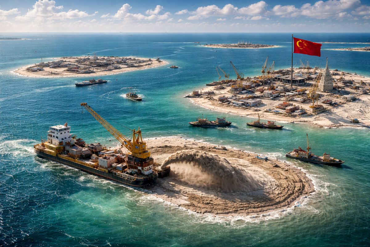
With China Authorizing the Construction of Islands in the Sea from Millions of Tons of Sand and Sediments, Reefs Enter the Center of a Dispute that Mixes Real Estate, Territorial Sovereignty, and Maritime Surveillance. The Project, Discussed Since 2013 and Estimated for 2026, Faces Environmental Criticism and External Pressure.
China, now pointed out as the second largest economy in the world, brings back a project that seems simple in its announcement but complex in its effect: using sand and sediments to create islands where reefs currently exist. The public promise speaks of lodging “in the middle of the ocean” and a technological showcase, but the geopolitical context appears in the same package.
What makes the case sensitive is the sum of three factors: the location in the Nansha and Xisha archipelagos, also known as the Spratly and Paracel Islands, the prospect of 2026 as the execution milestone, and the perception that new islands can reinforce surveillance, military control, and protection of trade routes. It is in this friction between engineering, ecosystems, and strategy that the debate gains weight.
Where the Islands Enter the Map and Why This Comes Back in 2026

The decision to resume the plan was described as a move that began to be discussed in 2013, was halted by cost, and now returns under the endorsement of Chinese authorities.
-
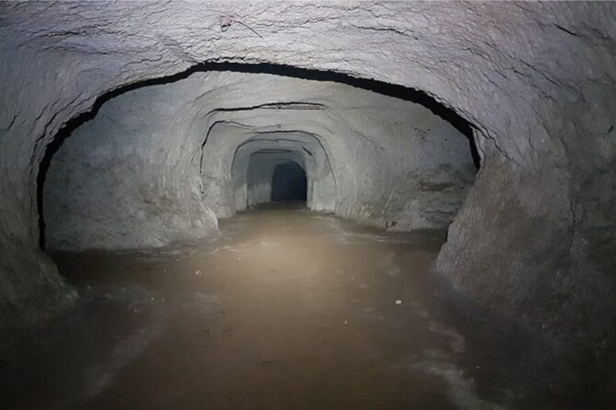
Discovery of a 15-kilometer labyrinth beneath the buildings of Rome raises alarm for collapses and reveals the largest underground network ever found in the Italian capital.
-
A rare storm phenomenon in the United States alerts meteorologists worldwide due to four different forms of water falling from the sky, which freeze immediately upon touching the ground, poles, cars, or trees.

-
He has been using a wheelchair for almost 10 years, lives alone, is independent, and decided to become a delivery driver for an app: Samuel makes up to 6 deliveries a day, covering routes of 1 km in his wheelchair and has even managed to do 2.5 km in a single run.

-
An island of 7,500 people received 38,000 bananas by mistake, was left unsure where to store everything, and turned the error into a viral case with donations, hustle, and fruit overflowing everywhere.


The year 2026 appears as a horizon to take the idea off the paper, creating a political clock: the execution window begins to be observed by neighboring governments and defense analysts.
In this context, the “where” matters as much as the “when.” Nansha and Xisha, or Spratly and Paracel, are areas mentioned as targets for the venture, and the choice to raise islands in these locations puts the project within a debate of territorial sovereignty.
Even without detailing coordinates, the fact that China links the plan to military control and maritime monitoring changes the perception of a project that, at first glance, could be treated merely as real estate.
Reefs, Sand, and the Invisible Detail Between Displacing and Destroying
The central technical stage is straightforward in its wording and harsh in its consequence: millions of tons of sand and sediments would be relocated onto reefs.
This physical transfer alters the environment through contact, weight, and coverage, and that is why scientists and critics treat the risk as potentially irreversible when sensitive marine ecosystems are buried or fragmented.
The invisible detail in this type of intervention lies in the interval between dumping and stabilization.
It’s not just about “creating land,” but transforming a living reef into a base of compacted sediment, and this exchange changes light, water circulation, and the dynamics that sustain corals and associated species.
Therefore, when China speaks of islands, the technical point that determines the impact is not the final shape but the process of depositing sand over the reefs.
Surveillance as Infrastructure and the Leap from Tourism to Strategy
The official argument mentions the possibility of hosting visitors from other nations in lodgings “in the middle of the ocean.”
Still, the very framing of the project includes territorial sovereignty, military control in the region, surveillance, and maritime monitoring, as well as protection of trade routes.
When these elements enter the same sentence, the purpose of the project ceases to be merely touristical.
In practice, new islands function as fixed platforms in an area where the sea generally imposes limits of permanence.
This expands the capacity for continuous presence and observation, even when China does not detail the systems.
For this reason, the discussion about islands is not limited to urbanism: it becomes about surveillance, reach, and political signaling, especially in a region already marked by disputes and suspicions.
External Pressure, Environmental Criticism, and the Accusation of Militarization
The external reaction comes in two layers.
The first is diplomatic: neighboring countries and experts see the creation of islands as a mechanism to reinforce claims and control the region.
The second is environmental: scholars point out that coral reefs and sensitive ecosystems would be affected by the advancement of the project, with damages that are hard to reverse.
The noise increases because the project carries a calculated ambiguity.
While the discourse emphasizes technology and tourism, the predominant reading outside the country is one of militarization, with reefs being converted into bases.
This discrepancy fuels external pressure and makes the central question less ecological and more strategic: what is being built and for what purpose of surveillance over time.
What Can Change for Trade Routes and Navigation Rules
The presentation of the plan links the initiative to the protection of trade routes, shifting the conversation to maritime traffic.
In transit areas, any expansion of presence can impact how ships assess risk, how governments project influence, and how surveillance over corridors is established.
It is not necessary to announce a formal change for the practical effect to begin to be felt.
That is why the episode weighs even without an exact address or a detailed timeline.
By creating islands over reefs with sand, China adds “land” where there were previously natural limits, and this can reposition the dispute over who observes, who patrols, and who defines the normality of circulation.
For 2026, the main thermometer will not be the project’s aesthetics but how it reconfigures surveillance and the perception of control at sea.
The construction of islands from sand and sediments, on top of reefs, is an intervention that draws attention for what it shows and, primarily, for what it enables.
When the discourse itself includes surveillance and military control, the debate shifts from being merely about environmental impact to being a discussion about power and predictability.
If you had to choose, what concerns you most about this type of project from China: the loss of reefs, the silent change in routes, or the increase in surveillance at sea that does not depend on a formal announcement to function?


-

-

-

-

-

-

35 pessoas reagiram a isso.