 Portuguese
  English
  Spanish
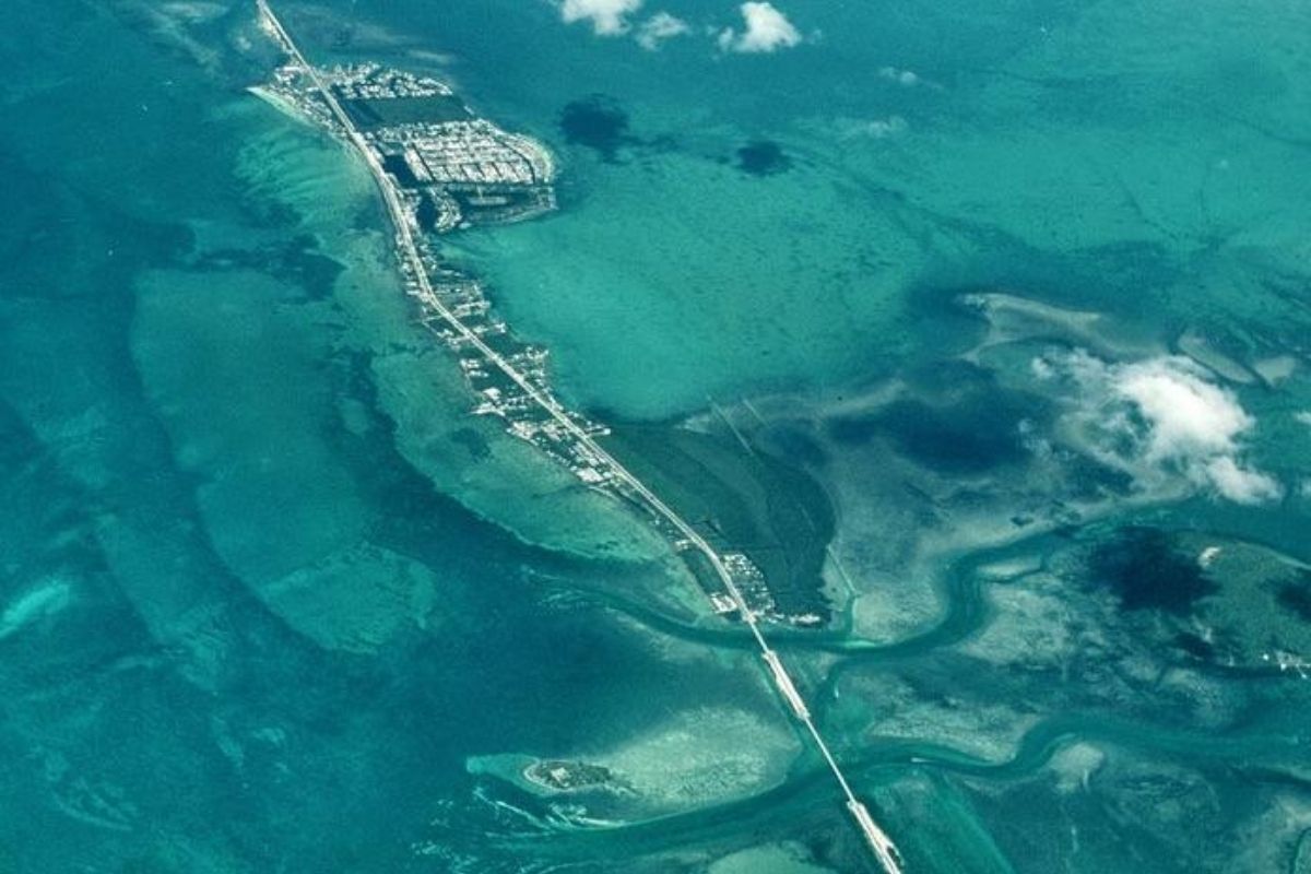


In Florida, The Road Crosses The Ocean By Connecting The Mainland To The Florida Keys: There Are 182 Kilometers Of Water Linking 44 Islands Through 42 Bridges. The Road Emerged After The Hurricane Of 1935 Destroyed The Overseas Railroad, Entered The New Deal And Established The Seven Mile Bridge, With 10.93 Km.
The Overseas Highway in Florida Has Become A Engineering Reference Because The Geography Forces Improvisation: To Move Forward, The Road Crosses The Ocean Repeatedly, Alternating Sections Of Land And Raised Passages. The Result Is A Corridor Of 182 Kilometers That Connects The Mainland To The Florida Keys And Transforms Water Into A Constant Horizon.
The Route Also Carries Memory Of Disaster And Reconstruction. The Overseas Highway Replaced The Old Overseas Railroad, Destroyed By A Hurricane In 1935, And Was Incorporated Into The New Deal Projects. Among 42 Bridges, The Most Symbolic Is The Seven Mile Bridge, At About 10.93 Kilometers, Now Treated As A Postcard Of Florida.
Where It Is And Why The Road Crosses The Ocean In The Florida Keys

The Landscape Of The Florida Keys Is Made Up Of Islands Aligned Like Steps Over The Sea.
-
At 73.8 meters tall, the world’s tallest teapot-shaped building has 15 floors, ensures stability, and impresses with an internal space of 28,000 cubic meters.

-
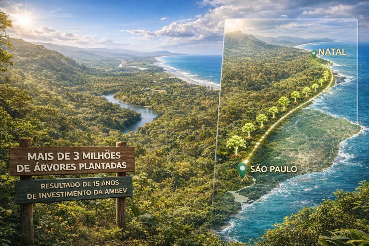
Ambev has planted over 3 million trees and restored an area equivalent to the coastline from São Paulo to Natal, and the result after 15 years of silent investment has finally appeared for all of Brazil to see.
-
A new AI collar technology for cattle eliminates physical fences, creates virtual barriers, monitors animals 24/7, and detects changes in behavior and health.

-
For a few weeks each year, an entire country blooms with billions of tulips, creating a mosaic of colors visible from the sky, while a single garden gathers more than 7 million flowers and attracts visitors from around the world to one of the most impressive shows in Europe.

It Is In This Scenery That The Road Crosses The Ocean For Approximately 182 Kilometers, Connecting 44 Islands Through 42 Bridges.
In Practice, The Driver Leaves The Mainland And Starts Crossing Successive Channels, Always With Water On Both Sides.
In Florida, The Overseas Highway Is Described As A Unique Experience Because The Highway Line Follows The Edge Of Low Islands And Narrow Cutouts.
Each Bridge Functions As A Piece Of Continuity, Maintaining The Flow Between The Florida Keys Without Relying On Ferries Or Interruptions.
1935 Hurricane, Fall Of The Overseas Railroad, And The New Deal Shift

The History Of The Overseas Highway Is Inseparable From A Landmark Of Destruction.
In 1935, A Hurricane Devastated The Overseas Railroad, A Railroad That Linked The Archipelago.
The Response Was To Reorganize The Layout And Transform The Corridor Into A Highway, Using The Public Effort Associated With The New Deal.
The Reconstruction Was Not Just A Modal Shift. In Florida, The Decision To Maintain The Connection With The Florida Keys Meant Preserving Mobility And Integrating Islands That Depended On A Fixed Axis.
The Overseas Highway Thus Emerges As A Symbol Of Resilience And Adaptation To A Territory Where The Sea Imposes Physical Limits.
Seven Mile Bridge And The 42 Bridges That Support The Route
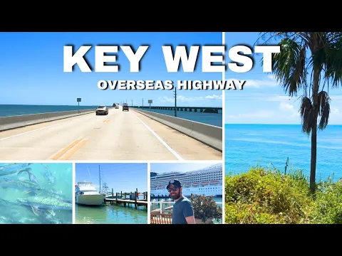
Among The 42 Bridges Of The Overseas Highway, The Seven Mile Bridge Has Become The Most Famous.
At About 10.93 Kilometers, It Summarizes What The Route Has Of Most Extreme: A Long, Exposed Stretch, With Open Water On Both Sides And A Constant Sense Of Crossing.
The Presence Of The Seven Mile Bridge Also Helps To Understand Why The Road Crosses The Ocean So Many Times. The Bridges Are Not Just An Aesthetic Detail; They Are The Central Mechanism For Uniting The 44 Islands.
Therefore, When It Comes To Landscape And Engineering In Florida, The Overseas Highway Appears As A Synthesis Of Practical Solution And Visual Impact.
Classic Stops Between Key Largo And Key West
Along The Overseas Highway, The Stops Change The Pace Of The Journey.
In Key Largo And Islamorada, The Route Is Often Associated With Activities Such As Scuba Diving And Sport Fishing, Taking Advantage Of The Tourist Infrastructure Of The Florida Keys And Easy Access To The Sea.
In Big Pine Key, The Highlight Is The Possibility Of Seeing The Key Deer, Described As An Endangered Species.
Meanwhile, Bahia Honda State Park Serves As A Beach And Tranquility Spot Along The Route In Florida.
At The End Of The Road, Key West Concentrates Caribbean Influences And American History, Including The Former Residence Of Writer Ernest Hemingway, An Element That Reinforces The Cultural Character Of The Route.
Between The Memory Of The Railroad And The Demands Of Current Traffic
Even With A Focus On Vehicle Traffic, The Overseas Highway Preserves Historical Layers By Occupying The Corridor Previously Linked To The Overseas Railroad.
The Road Crosses The Ocean With The Same Logic: Ensuring Continuity Between The Florida Keys And The Mainland, Now In A Highway Format.
This Balance Between The Past And Current Use Is Part Of The Reason Florida Treats The Route As A Symbol.
The Overseas Highway Combines Logistics, Landscape, And Historical Narrative In A Single Stretch Of Asphalt, Supported By Bridges And Marked By The Memory Of The 1935 Hurricane.
To Transform The Route Into A Complete Experience, The Practical Recommendation Is Simple: Plan Short And Frequent Stops, Set Aside Specific Time To Observe The Seven Mile Bridge, And Arrive In Key West With Leeway To Stroll And Document The Historical Part Of The Route.
Which Stop On The Overseas Highway Would You Consider A Must-Stop In The Florida Keys: The Seven Mile Bridge, Big Pine Key With The Key Deer, Or Key West With The House Of Ernest Hemingway?


Todos os pontos eu coloco como fundamentais para uma futura visita á Flórida.