 Portuguese
  English
  Spanish
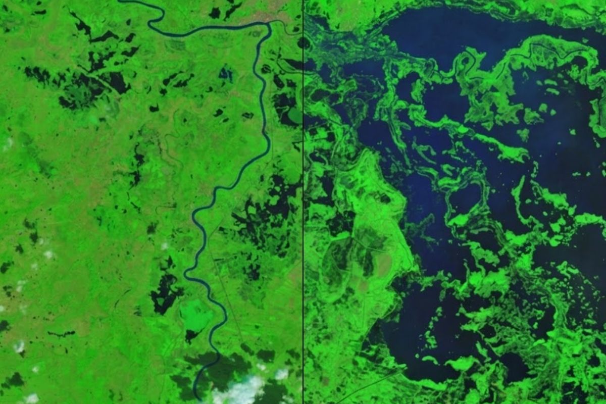
Images from NASA’s Landsat 9 satellite revealed a giant lake covering vast areas of Córdoba, Colombia, where weeks before there were agricultural lands and pastures. The floods of February 2026 hit more than 80% of the department, displacing 11 thousand families and flooding more than 150 thousand hectares of productive lands.
A giant lake appeared where none existed. When NASA’s Earth Observatory compared satellite images from January 23 and February 9, 2026, the difference was hard to ignore: a vast expanse of dark water covered areas that, just days before, were farms, pastures, and communities near the Sinú River in Córdoba department, northern Colombia. More than 80% of Córdoba was submerged, according to NASA, creating a landscape that, viewed from space, appeared to have gained a body of water the size of an entire region.
What makes this story even more disturbing is the timing of the event. February is usually one of the driest months in Córdoba, the period when farmers prepare the land for planting and ranchers move cattle to the plains that typically dry out. Instead, an unusual Caribbean cold front pushed moisture inland and triggered such intense rains that reshaped the landscape almost overnight, transforming a giant lake visible from space into the most dramatic portrait of the Colombian floods of 2026.
What caused the giant lake that appeared in Córdoba

IMAGE: NASA
The main factor behind the formation of this giant lake was a cold front that moved south through the Caribbean on February 1 and 2. This system forced moisture-laden air against the Colombian Andes, a weather setup that produced several consecutive days of intense rain. Some areas received between 4 and 7 centimeters of precipitation per day, with rates near Lorica, one of the most affected cities, reaching 1.7 centimeters per hour during peak intensity.
-
China has just launched for the first time the CH-7, a stealth drone in the shape of a flying wing that flies at 925 kilometers per hour, is nearly invisible to radar, and was designed to monitor battlefields and entire oceans.

-
Found in Giza 100 years ago, an Egyptian dress made of 7,000 beads belonged to a woman from the time of Khufu and impresses with the details preserved after millennia.

-
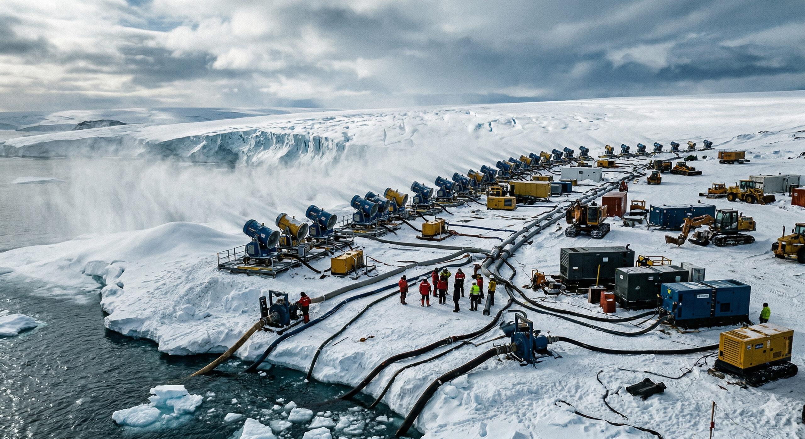
With 7.4 trillion tons of artificial snow pumped in 10 years, an extreme operation could stabilize the West Antarctic ice sheet and prevent a sea level rise of more than 3 meters, but it would require snow cannons, ocean water, and energy on an almost industrial scale at the end of the world.
-
The US no longer wants to deal with data centers: the state may prohibit projects of 20 MW that consume as much as 15,000 homes, while AI already requires energy from millions of households and even half a liter of water for 50 questions.

The scenario was already unfavorable before the cold front. January 2026 had been rainier than normal, meaning the soil was already saturated when the February rains arrived. With the land unable to absorb more water and rivers overflowing, the flooding quickly spread across farmland, pastures, and communities, creating the giant lake that satellites recorded. A climate attribution analysis by ClimaMeter classified the weather conditions as exceptional and suggested that similar events in the current climate tend to be wetter than comparable episodes in the past, although confidence in this conclusion is limited by the historical rarity of the event.
The scale of the destruction caused by the giant lake in Córdoba

image: NASA
Viewed from space, the flooding looks like a dark mirror spread across the landscape. On the ground, the impact was devastating. NASA reported that more than 80% of the Córdoba department was submerged, while preliminary estimates pointed to thousands of destroyed homes and more than 11 thousand families displaced. About 150 thousand hectares of agricultural land were flooded, equivalent to approximately 370,700 acres of compromised agricultural production.
The Colombian disaster management agency (UNGRD) added data that dimensions the catastrophe. Using satellite mapping, UNGRD estimated that, by February 9, the total area affected in Córdoba alone was 113,641 hectares, and this number did not yet include all fully accounted impacts. A European humanitarian report indicated that more than 200 thousand residents were affected by the floods and warned that environmental degradation and poor planning leave communities even more vulnerable when rivers overflow and fields turn into lakes.
Why the water from the giant lake did not drain quickly
One of the most concerning characteristics of this flooding was its persistence. It was not a brief episode that disappeared with the end of the rains. NASA observed that storms continued to hit the region in the following weeks, and images from the Earth satellite on February 25 still showed flooding spread across the area, nearly three weeks after the disaster began. The giant lake that formed over Córdoba simply did not recede.
In practice, this persistence of water makes all the difference for those living in the region. When the flood remains stagnant, planting is delayed, cattle movement becomes impossible, roads become impassable, and the impact on families continues to worsen even after the weather improves. For farmers and ranchers in Córdoba, February 2026 was not just a month of heavy rain. It was the month when the seasonal calendar that guides their survival simply stopped working.
How satellites helped respond to the giant lake emergency
One of the most relevant lessons from this disaster is the role that satellites played not only in documentation but in responding to the emergency. UNGRD activated the International Charter “Space and Major Disasters” and requested emergency mapping from the European Copernicus program, receiving 152 optical and radar products to define the extent of the flooding and support the decisions of rescue teams on the ground.
The principle is straightforward: when an entire region is flooded and land access becomes impossible, accurate satellite images are the only way to quickly identify which communities, roads, and agricultural zones were most affected. This information allows directing helicopters, boats, and supplies to where the need is greatest, instead of operating blindly. The giant lake that NASA satellites recorded was not just a portrait of destruction but a tool that helped save lives by showing in near real-time the extent of the disaster.
What the Córdoba flood reveals about the climatic future
The Córdoba event is not just a story about extreme rains in a remote corner of Colombia. It is a warning about how climate change can turn rare weather events into unprecedented disasters, especially in rural areas that depend on predictable seasonal cycles. ClimaMeter’s analysis reinforces this concern by indicating that episodes like this tend to be more intense in the current climate than they were in the past.
For the more than 200 thousand people affected in Córdoba, the issue is not abstract. When the driest month of the year produces the largest giant lake ever recorded in the region, confidence in the climate patterns that guided generations of farmers and ranchers crumbles. The old seasonal calendar has ceased to be a reliable guide. What happened in February 2026 is a reminder that vulnerability lies not only in the climate but in the capacity of communities and governments to prepare for events that, until recently, no one considered possible.
A giant lake appeared out of nowhere where there were once farms in Colombia, and NASA satellites recorded everything from space. Do you think extreme weather events like this will become more common? How should agricultural countries prepare?


Seja o primeiro a reagir!