 Portuguese
  English
  Spanish
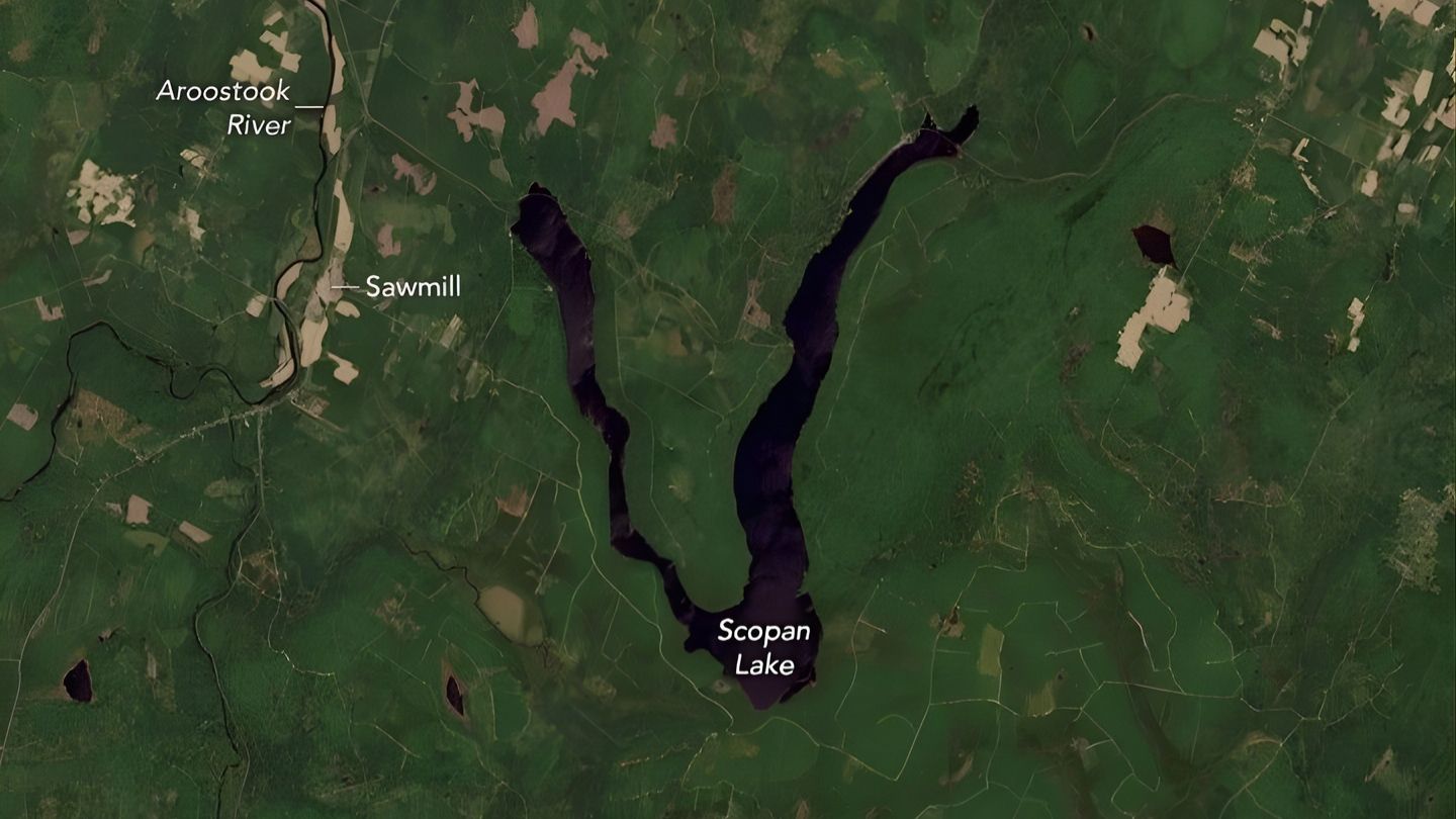
NASA image reveals a “V”-shaped lake in Maine, the result of a 1940s dam that transformed the landscape and caught the world’s attention.
In 2024, images captured by the Landsat 9 satellite, operated by NASA in partnership with the USGS, revealed an unusual detail in the landscape of the state of Maine, USA. Amid a region dominated by dense forests and scattered agricultural areas, a reservoir caught attention for its almost perfect “V” shape, visible directly from space. According to an analysis published on the official NASA Earth Observatory portal, the lake in question is Scopan Lake, located in Aroostook County. The image was recorded on June 2, 2024 by the Operational Land Imager-2 (OLI-2), one of the most advanced Earth observation instruments currently in operation.
What makes this lake truly unusual is not just its visual appearance. The “V” shape is not solely the result of natural processes, but rather a direct combination of geology, hydrology, and human intervention, something that rarely presents itself so clearly in orbital images.
Maine has thousands of lakes, but few with partially artificial origins
The state of Maine has a unique geographical characteristic within New England. According to data cited by NASA itself, there are about 6,000 named lakes and ponds, more than in any other state in the region.
-
NASA releases Google Maps resource to track the Artemis II Mission in real time and turns the app into a practical tool to visualize the spacecraft’s position and data directly on your phone.

-
Artificial intelligence helps create new antibiotics and could save millions of lives worldwide.

-
Science fiction got it wrong: a biologist from Rice University says that humans born on Mars would not be tall and slender like in the movies, but short, with thick bones, reinforced skulls, and possibly orange skin.
-
Sodium batteries are approaching the cost of lithium by 2027 and reinforce the trend of technological diversification in energy storage and electric vehicles.

Most of these formations are of natural origin, a direct result of the glacial eras, when glaciers advanced over the territory, excavating depressions and altering drainage systems. These processes gave rise to thousands of bodies of water distributed throughout the state.
However, a significant portion of these lakes is not entirely natural. Maine is also home to about 1,000 dams, many of which were built throughout the 20th century for power generation and water control. According to the U.S. Energy Information Administration (EIA), at least 51 of these dams are active hydroelectric plants, integrated into the local energy system.
The Scopan Lake fits exactly into this hybrid context of nature and engineering.
The role of the 1940s dam in forming the V shape
The most important detail for understanding the unusual shape of the lake lies in its formation history. The western arm of Scopan Lake emerged in the 1940s, after the construction of a small dam near the town of Masardis. This intervention completely altered the hydrological behavior of the region, connecting an artificially flooded area to an already existing lake.
This connection gave rise to the current shape of the reservoir, divided into two main segments:
- A northern arm, older and naturally formed
- A western arm, created by the rise in water level after the dam
This union resulted in an unusual geometry that, when observed from space, takes on the shape of a nearly perfect “V”.
Physical differences between the two arms of the lake reveal its origin
Another relevant technical aspect highlighted by NASA is the structural difference between the two parts of the lake.
The northern arm, corresponding to the original lake, has greater depth, with values exceeding 40 feet (approximately 12 meters).
On the other hand, the western arm, formed after the dam was built, is significantly shallower, reaching depths between 10 and 20 feet (3 to 6 meters).
This difference is not just a geographical detail. It practically confirms that the lake is the result of a hybrid process, where a natural formation was expanded and modified by human action, altering not only its shape but also its internal dynamics.
The landscape around reinforces the contrast between nature and human intervention
The surroundings of Scopan Lake are dominated by northern hardwood forests, composed of species such as:
- maple
- birch
- ash
- hemlock
- fir
These dense vegetation formations create a direct visual contrast with the open areas around the lake.
The interruptions in the forest cover are the result of three main factors:
- agricultural activities
- logging
- areas affected by fires or pests
One of the most relevant events in this context occurred between the 1970s and 1980s, when northern Maine faced outbreaks of the eastern spruce budworm, a pest that led to the removal of large areas of infested forest.
Additionally, the presence of a sawmill west of the lake highlights the ongoing economic use of the region.
The image was rotated to highlight the V shape
An important detail revealed by NASA itself is that the image of Scopan Lake was intentionally rotated to the northeast.
The purpose of this rotation was to further emphasize the “V” shape, making it visually clear for observers.
This type of approach is not isolated. The image of the lake is part of a special collection organized by NASA’s Landsat team, which gathers natural and artificial features of the Earth that resemble letters.
These images are used in an interactive tool that allows, among other things, to form words using real landscapes viewed from space, reinforcing the visual and educational value of this type of record.
Why Scopan Lake has become a rare case in modern geography
What makes Scopan Lake truly relevant is not just its aesthetics.
It represents a clear case of how the interaction between infrastructure and the natural environment can generate unique geographical shapes, visible on an orbital scale.
Unlike other landscapes shaped by dams, which generally follow irregular patterns, Scopan Lake presents a simple, readable, and almost symbolic geometry.
This type of formation:
- evidences human impact on natural systems
- demonstrates how small interventions can create large-scale visual effects
- reinforces the role of satellite images in interpreting the Earth’s landscape
What this lake reveals about how the planet is being transformed
The case of Scopan Lake goes beyond visual curiosity. It illustrates an increasingly common phenomenon: the transformation of natural environments through infrastructure, creating hybrid landscapes that mix geological processes with engineering.
The presence of thousands of dams in the United States and other regions of the world indicates that similar examples may exist, although few are as visually striking as this one.
The image recorded by NASA not only documents a lake but reveals a larger trend: the human capacity to redesign territory on a regional scale, often visibly even from space.
Have you ever seen a place on the planet that, viewed from space, looks like a letter or geometric shape as clear as this?


Seja o primeiro a reagir!