 Portuguese
  English
  Spanish
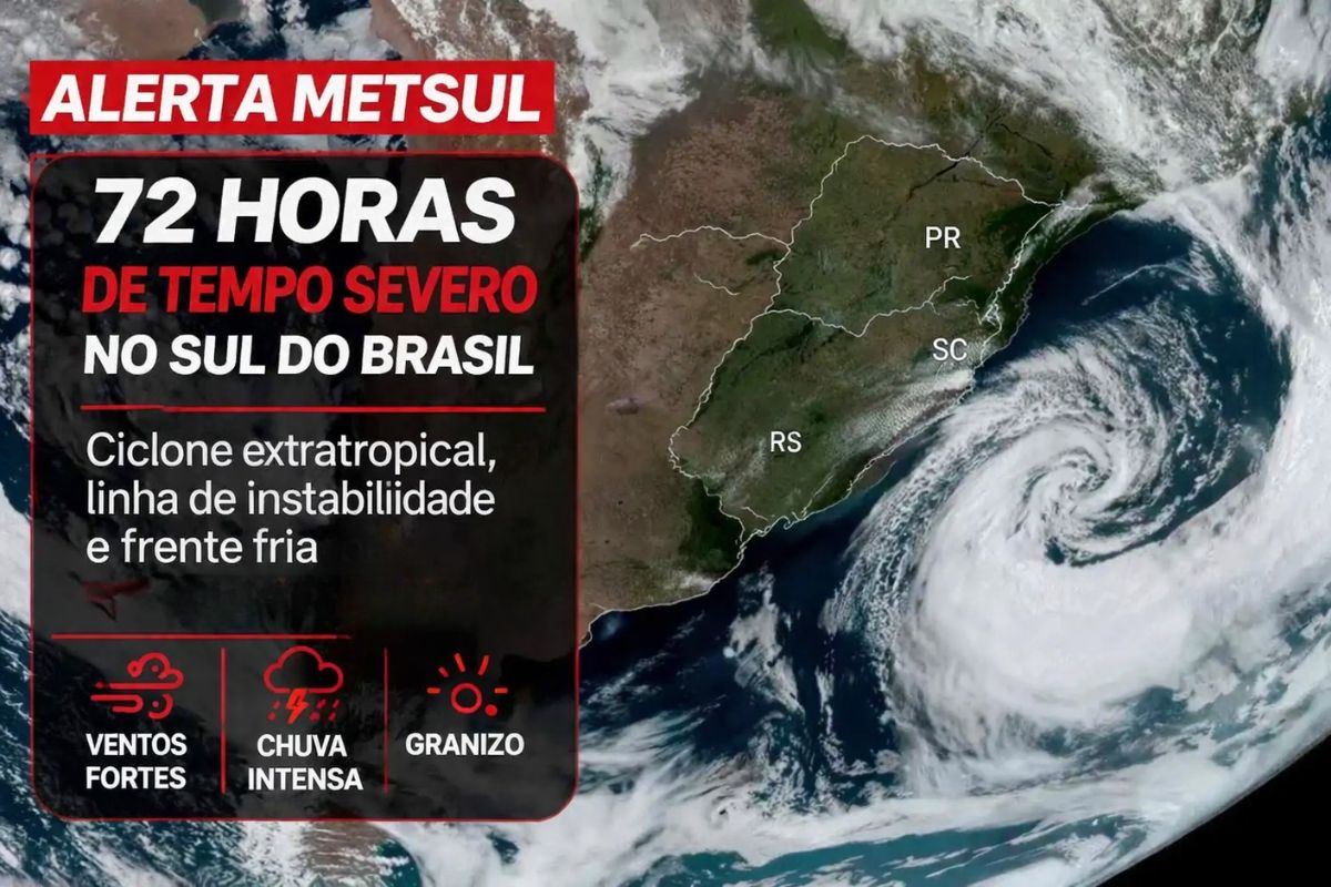
The cyclone will form in the River Plate between Buenos Aires and Montevideo and its action combined with instability line and cold front will create a high-risk scenario in Rio Grande do Sul between Monday and Wednesday with heavy showers, locally strong rain, and gales that may cause damage and power outages.
MetSul issued a warning for 72 hours of severe weather in southern Brazil. An extratropical cyclone forming, combined with instability line and cold front, will create a complex meteorological scenario between this Monday (6) and Wednesday (8) with a high risk of heavy rain, storms, and intense gales over Rio Grande do Sul. The period promises to be of high risk especially for the West, South, and the metropolitan region of Porto Alegre.
The alert is not for an isolated event; it is three consecutive days with different threats at each phase. The cyclone will form in the River Plate, between Buenos Aires and Montevideo, and its interaction with warm and cold air masses will generate increasing instability throughout the week. There is a possibility of locally strong to intense gales with the potential to cause damage and power outages, in addition to significant rainfall amounts in various regions of the state.
What will happen on Monday before the cyclone reaches Rio Grande do Sul
The week begins with the return of a warm air mass over southern Brazil. After the cool down on Sunday (5), the temperature will rise sharply on Monday (6) with heat in many cities in Rio Grande do Sul, favored by a low-pressure center in northeastern Argentina.
-
Scientists have built a prototype of a quantum battery that actually works, charges faster as it gets larger, stores and releases energy using quantum physics instead of chemical reactions, and can be wirelessly charged by laser.

-
New technology allows payment with the palm of the hand and may replace cards and cell phones in Brazil; The system is in development and uses the unique patterns of the veins in the hand to make the payment.

-
Scientist who “predicted” the pandemic issues new warning, says the world may be entering a phase of disintegration and urges us to prepare for what is to come.

-
NASA released a photo taken from the International Space Station showing a lightning bolt shooting upwards into space instead of falling to Earth, reaching nearly 100 kilometers in altitude at the top of a storm.

It is this low-pressure area that will evolve in the following days to give rise to the extratropical cyclone.
The interaction between the warm air and the Argentine low pressure will bring rain to several points in Rio Grande do Sul already on Monday, especially from afternoon to night.
The Western half of the state is the most exposed region on this first day, with a risk of locally strong rain and localized storms. The high temperatures act as fuel for instability; the hotter the air, the more energy available to feed storms when instability arrives.
Tuesday is the most dangerous day with the cyclone and the instability line
The risk scenario significantly worsens on Tuesday (7). An instability line will move ahead of a cold front associated with the cyclone, which at this moment will already be formed in the River Plate, between Buenos Aires and Montevideo.
This combination of an organized cyclone, advancing cold front, and instability line running ahead is the type of meteorological configuration that produces the most severe events.
As it moves through Rio Grande do Sul, the instability line will bring heavy rain to several points and storms with a high risk of gales, especially in the second half of the day.
The rainfall amounts can be high in the West and South of the state, where it should rain from early on, but the risk of gales will be greater from afternoon to night in the North and Northeast of Rio Grande do Sul, including the Porto Alegre region.
In the capital and surrounding areas, the temperature will rise with heat and hours of sunshine before the arrival of the instability line, which increases the energy available for more intense storms when the system finally advances. MetSul warns of the possibility of locally strong to intense gales, with material damage and power outages.
What the cyclone does on Wednesday and why the wind continues
On Wednesday (8), the extratropical cyclone will already be over the Atlantic Ocean, positioned to the east and southeast of Uruguay. At this stage, it no longer causes storms over the state, but still has direct consequences.
The cyclone will generate wind gusts close to 100 km/h in the South and East of Uruguay and bring significant winds to the South and East of Rio Grande do Sul.
The gusts in Rio Grande do Sul should average between 60 and 80 km/h, but may be individually higher in the Southern Coast and in the area of Lagoa dos Patos and surroundings. Even with the cyclone already in the ocean, the prolonged wind for many hours is a risk that cannot be ignored, especially in coastal areas, where sustained winds can cause rough seas and high waves.
The weather should only normalize from Thursday, when the system moves far enough away to stop influencing the state.
How to prepare for the 72 hours of severe weather generated by the cyclone
MetSul emphasizes that the scenario requires continuous attention between Monday and Wednesday.
Residents of the West and South of Rio Grande do Sul should prepare for heavy rain starting Monday, while those in the North, Northeast, and metropolitan region of Porto Alegre need to be especially attentive on Tuesday afternoon and evening, when the combination of heat and instability line may generate the most intense gales of the period.
For Wednesday, attention turns to the Southern Coast and the Lagoa dos Patos region, where the wind associated with the cyclone will be more persistent. It is recommended to secure loose objects in outdoor areas, avoid parking under trees during the risk period, and keep devices charged in case of power outages.
The cyclone and its effects will be continuously monitored by MetSul and Civil Defense; following daily updates is essential because the scenario may change in details as the system evolves.
Are you in the risk area of this cyclone? How are you preparing for the next 72 hours?


Seja o primeiro a reagir!