 Portuguese
  English
  Spanish
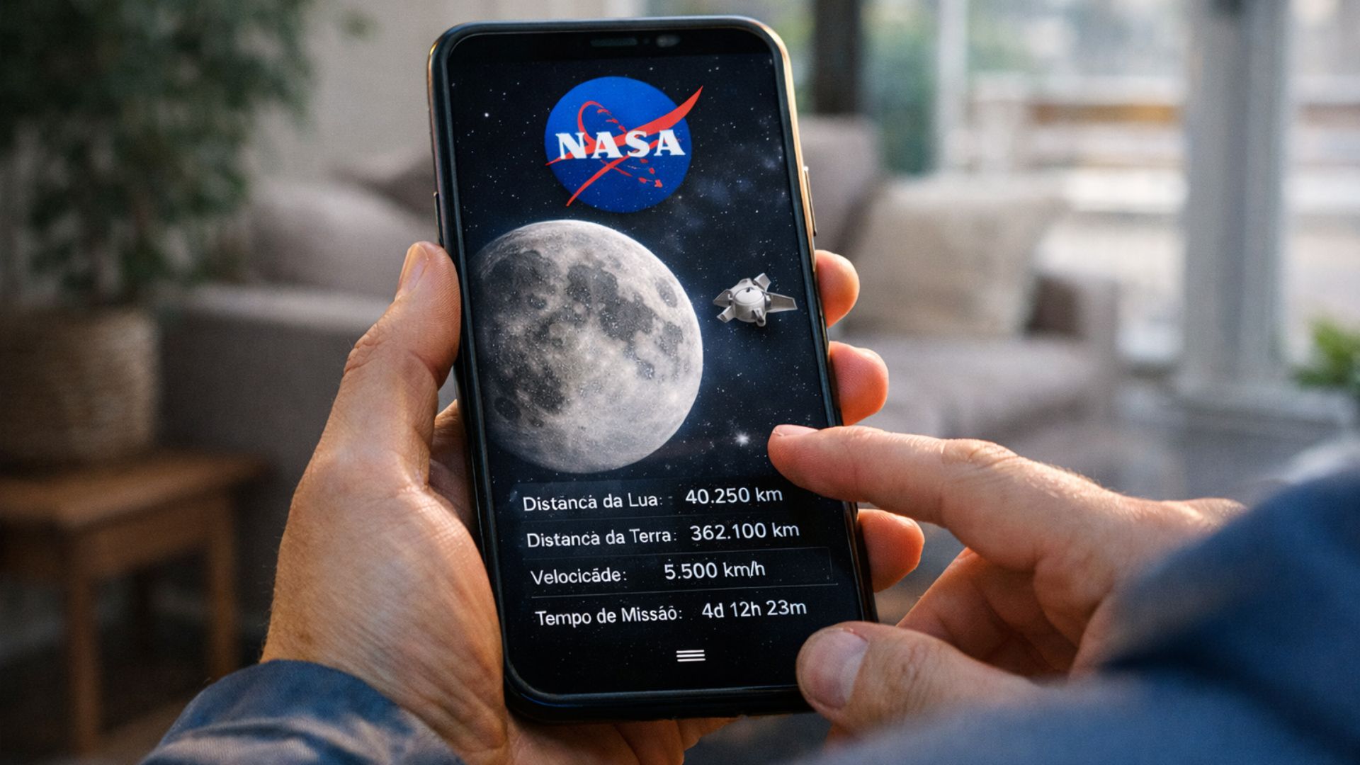
Follow the Artemis II Mission in real-time with NASA’s interactive tool that integrates Google Maps features and a mobile app, allowing you to visualize trajectory, speed, and spacecraft data directly from your phone with ease and precision.
The NASA has taken a new step in how the public follows space exploration by launching a Google Maps feature that allows tracking the Artemis II Mission in real-time. According to the Xataka Brasil, the innovation transforms the app into a practical and accessible tool, capable of showing the position of the Orion spacecraft, its speed, and the distance from Earth and the Moon directly on your phone.
The mission, launched on April 1 from Launch Complex 39B at the Kennedy Space Center in Florida, is expected to last about 10 days. Despite being relatively short, it is an extremely complex operation that can now be followed in detail by anyone with internet access. The initiative broadens the reach of science and brings the public closer to a historic journey.
How NASA’s Google Maps feature puts the Artemis II Mission in the palm of your hand
The NASA developed the Artemis Real-Time Orbit (AROW) platform, which works similarly to the Google Maps feature, allowing for constant updates on the Artemis II Mission. The interface is designed to be intuitive, making it easy to access both in browsers and on mobile app.
-
China does not want to depend on oil and is advancing in ‘water’-powered airplanes amid the energy crisis affecting the whole world.

-
Artificial intelligence helps create new antibiotics and could save millions of lives worldwide.

-
Science fiction got it wrong: a biologist from Rice University says that humans born on Mars would not be tall and slender like in the movies, but short, with thick bones, reinforced skulls, and possibly orange skin.
-
Sodium batteries are approaching the cost of lithium by 2027 and reinforce the trend of technological diversification in energy storage and electric vehicles.

When opening the tool, the user sees a three-dimensional model of the Orion spacecraft moving in space. It is possible to navigate freely through the environment, observing the spacecraft’s position relative to Earth, the Moon, and the Sun. This approach transforms technical data into a clear and engaging visual experience.
Among the displayed information, the following stand out:
- Elapsed time since launch
- Current speed of the spacecraft
- Distance from Earth
- Distance to the Moon
This level of detail reinforces NASA‘s commitment to transparency and makes the Google Maps feature an efficient bridge between science and the public.
Artemis II Mission marks a welcome return after more than 50 years
The Artemis II Mission is considered one of the most important projects of the current generation of NASA. It marks the return of astronauts to the lunar environment after more than 50 years, since the Apollo missions.
Unlike past operations, Artemis II uses more advanced technologies and modern navigation systems. The Orion spacecraft was designed to offer greater safety, efficiency, and crew support during the journey.
During the approximately 10 days of the mission, the spacecraft will perform a trajectory around the Moon before returning to Earth. This route serves as preparation for future missions that aim to take astronauts back to the lunar surface.
In this context, the Google Maps feature emerges as an important ally in broadening access to information, while the app facilitates continuous tracking of the mission.

Augmented reality app highlights practical advantage for following the mission
Although the web version is sufficient to follow the mission, the major differentiator is the mobile app. The NASA has incorporated augmented reality features that make the experience more interactive.
With this functionality, the user can point their phone to the sky and visualize the position of the Orion spacecraft in relation to their own field of view. This integration transforms the Google Maps feature into something even more intuitive and immersive.
Among the main benefits of the app are:
- Free use on Android and iOS devices
- Interface adapted for touch screens
- Real-time visualization of the Artemis II Mission
- Interactive experience with augmented reality
This innovation shows how NASA seeks to bring space exploration closer to people’s everyday lives.
How to access the Google Maps feature and follow the Artemis II Mission
Accessing the Google Maps feature created by NASA is simple and does not require technical knowledge. The platform was developed to function throughout the Artemis II Mission, ensuring real-time updated data.
The user can choose to access it directly through the browser or use the app. In both cases, the experience is smooth and allows exploring different perspectives of the mission.
While navigating the interface, it is possible to:
- Track the trajectory of the Orion spacecraft
- Explore the space around the mission
- View constantly updated data
- Understand the dynamics of space movement
This format reinforces NASA‘s role in creating accessible and educational tools, using the Google Maps feature as a basis for an intuitive experience. The app is available for Android and iOS.
NASA expands global engagement with accessible technology and real-time data
The strategy of NASA goes beyond technological innovation. By integrating the Google Maps feature with a functional app, the agency significantly increases global engagement with the Artemis II Mission.
This approach has a direct impact on education and scientific dissemination. Students, teachers, and enthusiasts can follow the mission in real-time, understanding complex concepts more simply.
Moreover, the availability of updated data strengthens the transparency of space operations. NASA demonstrates that space exploration can be shared with the public in a clear and accessible manner.
The role of the Google Maps feature in NASA’s new communication
The use of the Google Maps feature represents a shift in how NASA communicates its missions. The Artemis II Mission is no longer followed only by specialists but is now accessible to anyone with a smartphone.
The app acts as an intermediary between complex data and the average user. This reduces barriers and allows more people to become interested in science and technology.
This transformation can influence future initiatives, consolidating a model in which information is shared in a more open and interactive way.
A new way to follow the Artemis II Mission in real-time
The combination of the Google Maps feature and the Artemis II Mission creates an unprecedented experience for the public. For the first time, it is possible to follow a space mission with this level of detail directly from your phone.
This innovation not only informs but also engages. By visualizing the spacecraft’s trajectory and its data in real-time, the user begins to better understand the challenges involved in space exploration.
More than a technological advance, it is an evolution in how science is shared. NASA reinforces its leadership role by making the Artemis II Mission accessible, interactive, and relevant to people around the world.


Seja o primeiro a reagir!