 Portuguese
  English
  Spanish
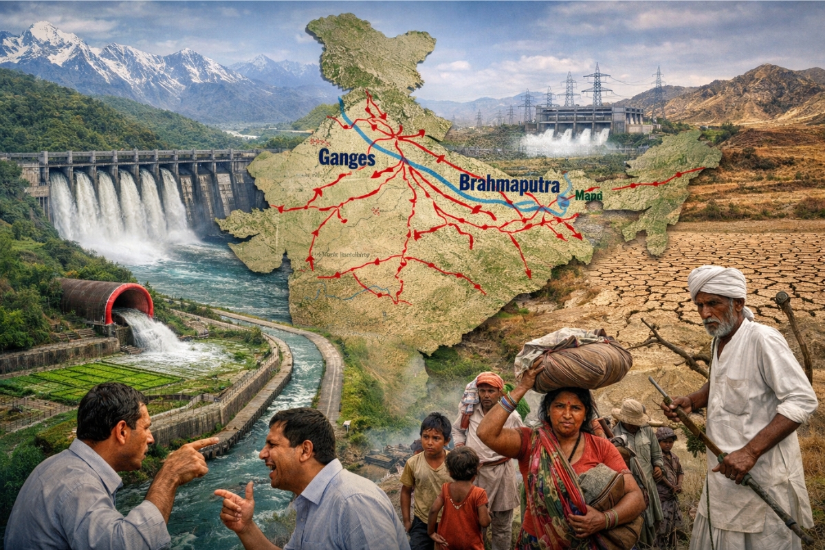


National Megaplan Promises Irrigation and Energy, but Intensifies the Dispute Between Donor and Recipient Water States
India has put the Inter Linking of Rivers program, known as ILR, at the center of the debate, a megaproject to connect around 30 major rivers.
The proposal uses canals and tunnels to move water from basins deemed surplus to drier regions, focusing on irrigation, hydroelectricity, and flood reduction.
The scale of the change disrupts local interests and opens a political and social dispute between donor and recipient states, with the risk of permanent internal conflict.
-
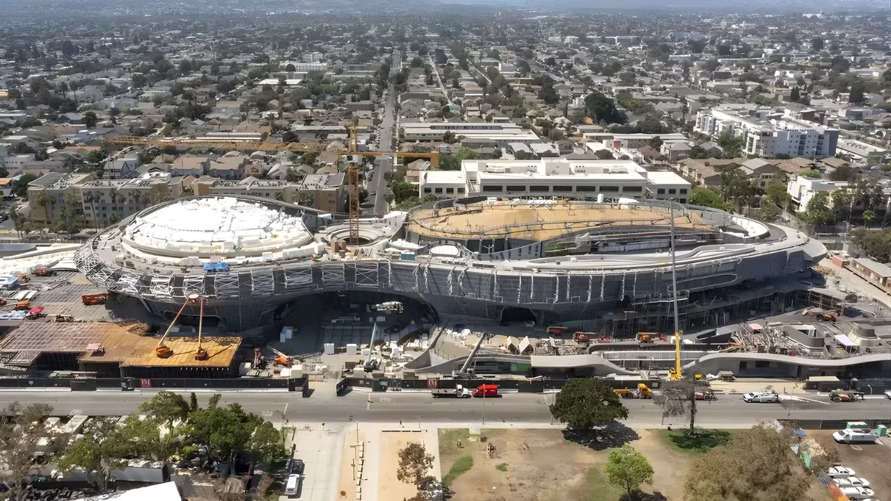
Created by George Lucas with over $1 billion, a futuristic museum in the shape of a spaceship with 1,500 curved panels is about to open in Los Angeles and will house one of the largest private collections of narrative art in the world.
-
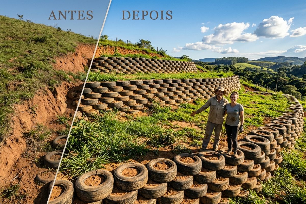
Couple shows how they built a retaining wall on their property using 400 old tires: sloped land turned into plateaus, tires are aligned, filled, and compacted with layers of soil, with grass helping in support and at almost zero cost.
-
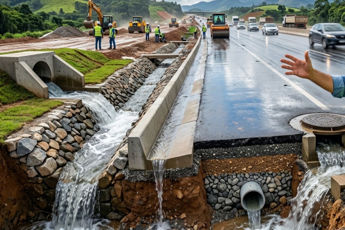
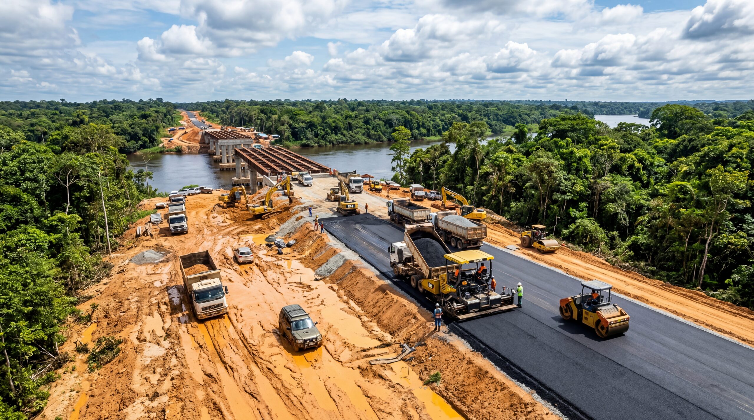
Engineer explains drainage during the rainy season: the difference between surface water and deep water, ditches, gutters, and water outlets on the road, as well as drains and drainage mattresses, to prevent erosion, aquaplaning, and flooding at the construction site today.
-
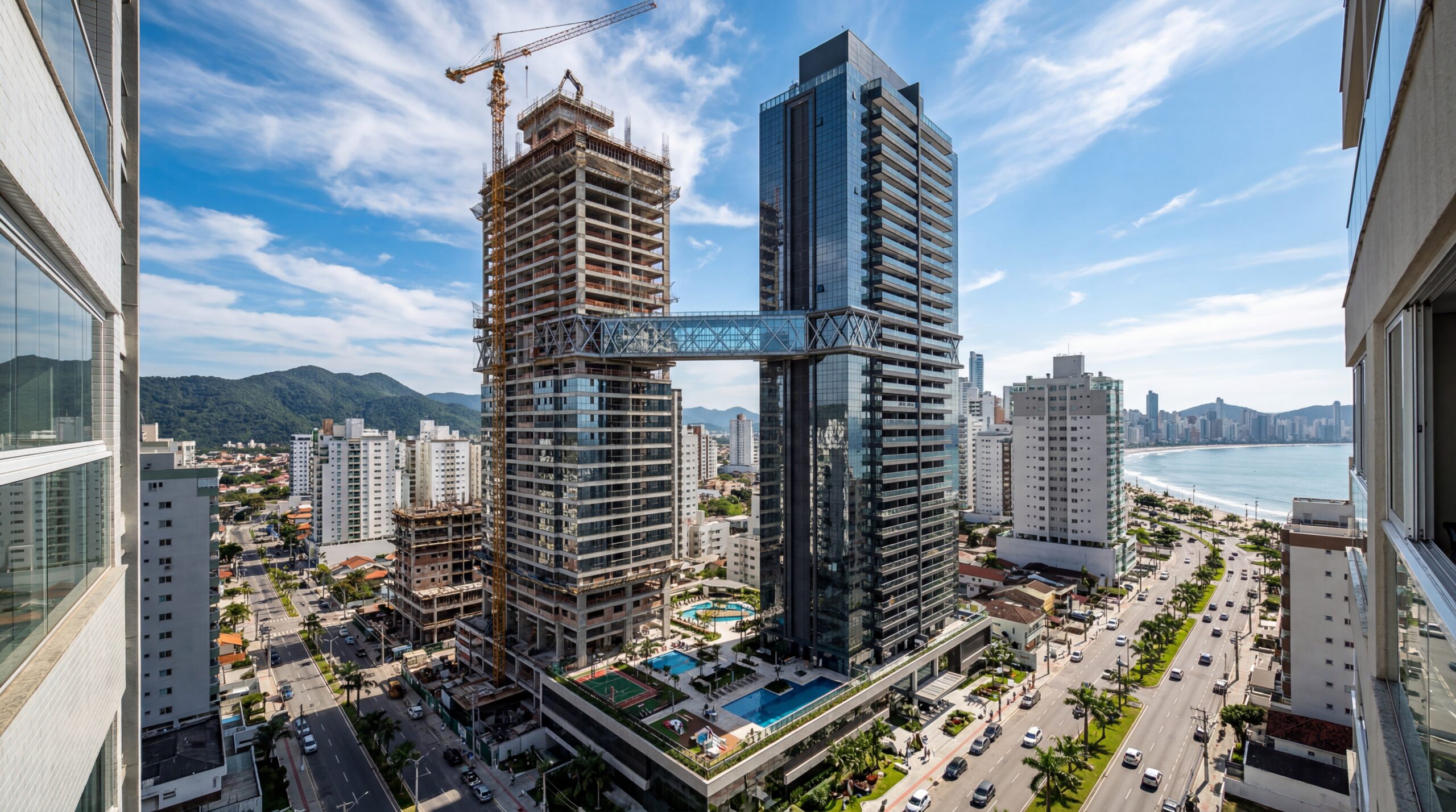
With 55 floors, 177 meters in height, a 15-meter walkway between the twin towers, ventilated facade, and 6,300 m² of leisure space, Ápice Towers already has one tower completed and another nearly at the top.

Connection Between Ganges and Brahmaputra Comes Into Focus and Changes the Water Game in the Country
The ILR aims to interlink rivers of great importance, including the Ganges and the Brahmaputra.
The central idea is to redistribute water on a national scale, changing the path of part of the flows that arrive with the monsoon rains and the melting of snow in Himalayan areas.
This brings the issue to the state level, as it involves who delivers water, who receives it, and how to maintain supply in different regions.
National Perspective Plan of the 80s Mapped 30 Connections and Became the Basis of the Megaproject

The plan took shape with the National Perspective Plan, launched in the 80s, which listed 30 possible connections.
In this design, 14 connections appear in the Himalayan region and 16 in Peninsular India, separating the linkages by blocks and water systems.
With this, the ILR ceased to be just a technical idea and began to be treated as a national strategy for water infrastructure.
Structure Plans Dams and Canals Hundreds of Kilometers Long to Transfer Excess Volumes
The rationale behind the ILR is based on a contrast: in the northeast and parts of the Himalayas, monsoon rains and melting snow raise rivers and can cause floods.
In western and central regions, lack of water limits agriculture and development, increasing the pressure for a more stable supply.
To facilitate this transfer, the project plans for dams, reservoirs, tunnels, and canals spanning hundreds of kilometers, redirecting part of the excess volumes to deficit basins.
Irrigation May Gain 35 Million Hectares and Reach 350,000 km² of Additional Area
The scope of the ILR includes gaining irrigated area and increasing energy capacity.
There is a forecast of additional irrigation of 35 million hectares, equivalent to 350,000 km², expanding support for agricultural production.
The goal involves changing the availability of water in regions currently facing scarcity, with a direct impact on water security.
Hydroelectricity Enters the Account With Estimates Between 34,000 MW and 40,000 MW
On the energy front, the project relies on hydroelectric capacity ranging from 34,000 MW to 40,000 MW.
This volume is associated with the use of large reservoirs, which would also function as large-scale water storage.
At the same time, the scale of the infrastructure increases the cost and complexity of operation and maintenance in the long term.
Supreme Court in 2012 Pressed for Advancements and Raised the Dispute Between States to Another Level
In 2012, a decision by the Supreme Court of India prompted demands for advancements in the project, elevating the issue to a national priority.
Drier regions began to see the ILR as a solution to water insecurity, while upstream states raised alarms about future losses.
The sensitive point is the balance of water power, since control of dams and transfers can affect local economies, supply, and agriculture.
Risks Include Displacement, Loss of Forests, and Impacts on the Natural Balance of Rivers
Inter-basin transfer projects often affect forests, rivers, and communities, especially when dependent on large reservoirs and extensive works.
Among the discussed risks are loss of vegetation cover, displacement of populations, conflicts between states, circulation of invasive species, and transportation of pollutants to new areas.
Another point is the dependence on a costly and complex infrastructure, which may become rigid in the face of climate changes and variations in monsoons.
Future of the ILR Divides Opinions and May Redefine Water Policy in India
The ILR remains an engineering bet to balance water, energy, and food security in a country with growing demand.
At the same time, climate uncertainty amplifies the weight of the debate regarding what is currently treated as surplus and what may become essential water in the future.
Ultimately, the decision to advance, adjust, or halt the Inter Linking of Rivers determines not only projects but also the shape of the political pact over water in India and the level of conflict between donor and recipient states.


Sobre o Inter Linking of Rivers (Índia) : Eu acho, que assim como o Sistema ferroviário nacional da Índia, como o Diamond Road um Sistema de Rodovia Nacional que Circunda a Índia (formato do Mapa da Índia) e a política de construção de 1 milhão de banheiros ; esta “Mega obra” é uma Infraestrutura Tronco ou Infraestrutura de Base para o Capital Social da Índia, que terá impactos se for bem analisado e discutido , para a Índia de forma positiva ! Como se fosse uma estrada hídrica (hidrovia) e/ou um complexo hidrelétrica com hidrovia de abrangência geográfica nacional (num país de quase 3,5 milhões de kms2. Ajudará a aumentar a disposição de água para consumo humano e tbm para a produção agrícola nacional ! .