 Portuguese
  English
  Spanish
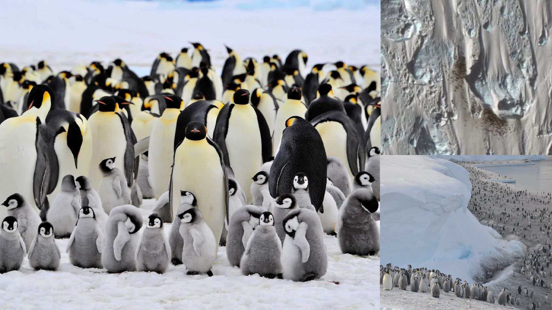
Guano Stains on Ice Became Clues for Locating Penguin Colonies in Antarctica Using Satellite Images, Expanding Monitoring in Remote and Hard-to-Access Areas. Technique Combines Visual Observation and Spectral Analysis to Confirm Breeding Sites and Update Maps Used by Researchers and Conservation Organizations.
Brownish stains amid the almost absolute white of Antarctica have become a valuable clue for science.
They are not exposed rocks or shadows, but guano — the droppings that accumulate around areas where penguins gather to breed and raise chicks.
This “trail” acts as a natural marker that can be identified in satellite images and, in some cases, allows for locating entire colonies in spots too remote for frequent visits by researchers.
-
How an innovative city combines high technology, well-being, and sustainability to become the largest reference in clean energy on the planet.

-
Couple buys 1846 church in ruins for R$ 660,000, invests R$ 3.2 million in renovations, transforms it into a millionaire mansion, and even preserved a historic cemetery with over 300 graves.

-
He started running at 66 years old, broke records at 82, and is now a subject of study for having a metabolic age comparable to that of a 20-year-old, in a case that is intriguing scientists and inspiring the world.

-
Oldest tree on the planet reappears after 130 years of searches: Wattieza, 385 million years old, was 10 meters tall and had no leaves or seeds; Gilboa fossils in New York solved the mystery in 2007.


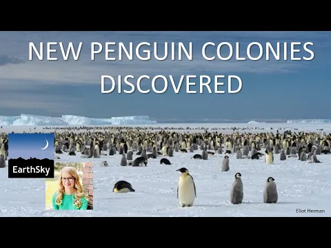
The logic is simple, but the result is significant: penguins are too small to appear as individuals in medium-resolution sensors, yet thousands of birds concentrated at one point leave a visible signature on the ground.
When conditions of lighting and surface are favorable, the stain stands out against the ice and snow, indicating not only presence but also the approximate position of a breeding site.
From there, specialists cross-reference images from different dates and compare them with previous records to confirm whether the signal is persistent and consistent with colony activity.
Sentinel-2 and Mapping Colonies in Antarctica
This type of monitoring has scaled up with the availability of satellites capable of frequently revisiting the Antarctic coast and producing comparable mosaics over time.
An example is the Copernicus Sentinel-2, used by teams systematically searching for the brown “ink” of guano in areas where emperor penguins typically establish themselves.
The scanning is not random: it focuses on coastal strips, ice shelves, and “fast ice” regions, the sea ice attached to the coast, a crucial environment for species reproduction in many areas of the continent.
How Scientists Confirm Colonies with High-Resolution Images
When a suspicious stain appears, the work does not end on the screen.
The confirmation often requires higher-resolution images that can better detail the texture of the site and differentiate guano from landscape features.
At this stage, commercial sensors come into play, such as the WorldView family, which allows for much clearer visibility of the dark spots associated with bird concentrations and the material deposited on the ice.
The combination of “detection” using broad coverage satellite detection and “confirmation” with detailed imagery reduces the chance of errors and strengthens records of new locations.

Discoveries from the British Antarctic Survey and New Breeding Sites
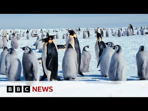
This is how researchers associated with the British Antarctic Survey reported the identification of emperor penguin breeding sites that were not included in previous surveys.
The discoveries help fill gaps in distribution and revise the global map of the species, historically limited by the cost and difficulty of operating in extreme environments.
Beyond locating new points, satellite monitoring also allows tracking the movements of colonies to nearby areas when ice conditions change, something that can alter the exact breeding location without the colony “disappearing” from the ecosystem.
Spectral Analysis of Guano and the Difference Between Ice and Snow
The technique relies on observable physical properties.
Guano, apart from being pigmented, has a different spectral behavior from ice and snow in certain bands of the spectrum, including infrared.
In remote sensing work conducted by researchers from British institutions, the spectral “signature” of guano was used to separate biological stains from natural surfaces, making the method more reliable than a simple visual inspection.
In practice, this means that the satellite is not just “photographing” a stain: it measures how the surface reflects light at different wavelengths, and this pattern can indicate organic material deposited in colonies.
Why the Colony Map Matters for Conservation

What changes with this type of discovery is not just the list of points on the map.
The count of known colonies is a cornerstone for population estimates and conservation planning, even if the number of locations does not automatically translate into a proportional jump in the total number of individuals.
Some newly identified colonies are small, and the technical literature itself notes that new records may have a modest impact on global estimates if the size of the groupings is limited.
Even so, the gain is significant because a more comprehensive mapping reduces uncertainties about distribution and helps direct future field campaigns, when necessary, to areas with a higher chance of scientific returns.
Historical Series and Continuous Monitoring in Remote Areas
Another direct effect is the possibility of creating historical series.
By comparing image archives over the years, researchers can check if a site appears repeatedly, if it changes position, and if it shows seasonal patterns consistent with breeding.
In regions where the ice fractures early or where ship access is unfeasible, this monitoring becomes one of the few practical means of continuous surveillance.
With each new revision of the map, the foundation for understanding where the species can maintain colonies and which stretches of coast are most used grows, crucial information for ecological studies and risk assessments.
Clouds, Shadows, and Challenges to See Signals on Ice
Antarctica offers a particularly favorable setting for the method because the landscape has large homogeneous areas of ice and snow, which increases contrast with guano stains in many situations.
Nonetheless, detection is not trivial: clouds, lighting variations, shadows, and the very dynamics of the ice can obscure signals.
For this reason, the approach often combines more than one satellite and multiple observation windows, as well as checking whether the stain appears at different moments, reducing the chance of confusing a singular event with an active breeding site.
Satellite Monitoring and Ecological Traces in Antarctica
While the public tends to be surprised by the idea of “finding penguins through their poop,” for science, the central point is different: it is about using a robust and measurable ecological hint to fill an information gap in one of the most inaccessible places on the planet.
By transforming traces into geographic data, the research expands the reach of monitoring, strengthens the record of colonies, and allows for the species map to be revised faster than would be possible with just in-person expeditions.
If such discreet stains on the ice can reveal entire colonies, what other signs left by animals in extreme environments may still be hidden in plain sight of satellites?


-

-

-

-

5 pessoas reagiram a isso.