 Portuguese
  English
  Spanish
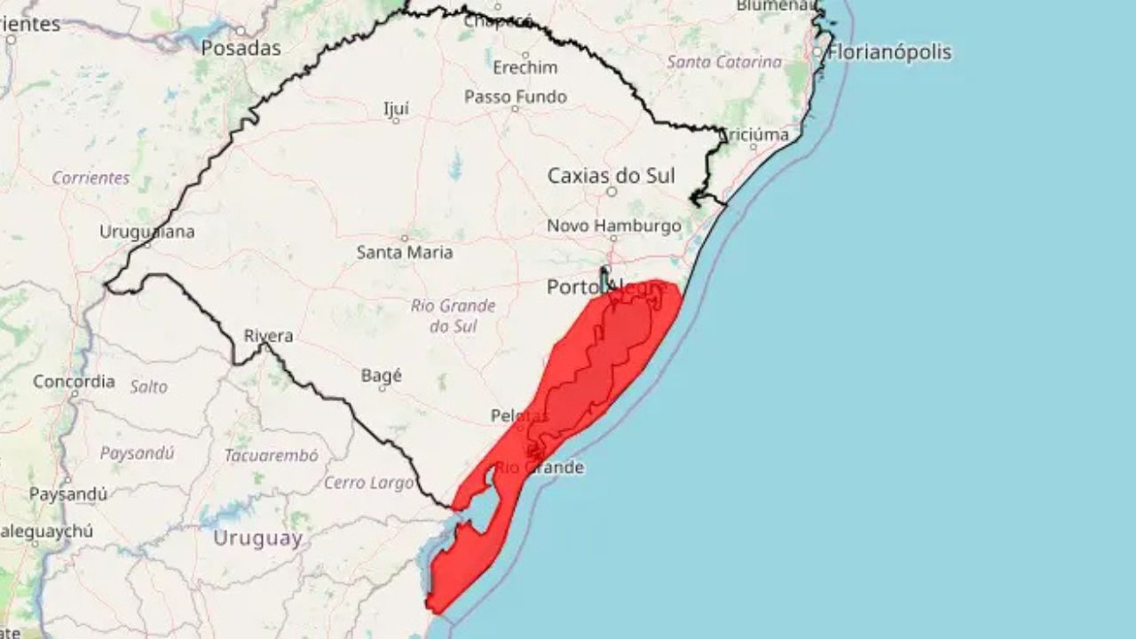
Inmet issues red alert for extratropical cyclone in southern Brazil with winds above 100 km/h and risk of severe damage.
On April 7, 2026, the National Institute of Meteorology (Inmet) issued a red alert of great danger for strong winds along the coast of Rio Grande do Sul, associated with the activity of an extratropical cyclone in the border region between Uruguay and the state. The official notice indicated a high risk of severe events, with winds exceeding 100 km/h and the potential to cause roof damage, falling trees, power outages, and impacts on agricultural areas.
The alert covered about 25 municipalities along the coast, including Porto Alegre, in a strip more exposed to the intensification of winds throughout Wednesday. In a statement, the Ministry of Integration and Regional Development reported that the system maintained a risk of damage to buildings, disruptions in transportation, and interruptions of essential services, reinforcing the severity of the scenario monitored by federal agencies.
On the Inmet scale, the red level represents the maximum degree of severity for this type of alert, indicating the possibility of significant impacts on urban infrastructure and public safety. In the case of Rio Grande do Sul, the combination of the cyclone’s advance and the concentration of the most intense effects on the coast placed the state under one of the most critical weather warnings issued by the agency at the beginning of April.
-
Brazil accelerates the development of a Brazilian rocket to launch small satellites and achieve space autonomy.
-
With hypersonic missiles priced like a Tesla, China is betting on a simple and devastating strategy to pressure the U.S.: mass production, saturating defenses, and turning cost into a weapon of military superiority.

-
An ancient and active ecosystem is revealed beneath a giant iceberg in Antarctica after a scientific expedition with a submarine robot at a depth of 1,300 meters, and the discovery surprises international researchers.

-
Chinese torpedo-shaped underwater drone found by fisherman in strategic waters of Indonesia.
Winds above 100 km/h and intense gusts put structures at risk
According to meteorological projections, the extratropical cyclone may generate wind gusts exceeding 100 km/h, with the possibility of even higher peaks in exposed areas, especially along the coast.
These conditions are sufficient to cause:
- roof damage in homes and buildings
- falling trees and poles
- damage to metal structures and roofs
- interruptions in the supply of electricity
The intensity of the winds is considered the main risk factor of this event, as gusts above 100 km/h have significant destructive potential, especially in urban areas and regions with vulnerable infrastructure.
Additionally, the combination with saturated soil increases the risk of falling trees and structural collapses.
Formation of the extratropical cyclone occurs between Uruguay and southern Brazil
The meteorological system develops from an area of low atmospheric pressure positioned between Uruguay and the extreme south of Brazil. This type of formation is typical of extratropical cyclones, which arise from the meeting of air masses with different temperatures and pressures.
As the system intensifies, it moves towards the Atlantic Ocean, but its effects expand over the continent, especially in the early phases.
This process can occur rapidly, with intensification in a matter of hours, which increases the difficulty of detailed forecasting and immediate response.
The movement of the system also influences the distribution of winds and the most affected areas.
Heavy rains, storms, and temperature drops accompany the system
In addition to strong winds, the extratropical cyclone also brings with it a series of other associated meteorological phenomena.
Forecasts indicate:
- rain accumulations that can vary between 50 mm and 120 mm
- occurrence of storms with electrical discharges
- possibility of hail in isolated areas
- sharp drop in temperature after the passage of the system
This combination transforms the event into a complex climate system, capable of affecting different sectors simultaneously.
Intense rainfall can worsen the scenario by causing urban flooding and increasing the risk of landslides in vulnerable areas.
Cities in the cyclone’s path concentrate a high risk of direct impacts
The 26 cities under alert are positioned in areas considered critical for the passage of the system. Municipalities such as Porto Alegre, Pelotas, Rio Grande, Viamão, Camaquã, and Jaguarão are among the points with the highest probability of impact.
The proximity to the coast and large bodies of water increases the potential for intense effects, including stronger winds and rapid variations in weather conditions.
These regions also have a history of similar events, which reinforces the need for heightened attention.
The actions of civil defense agencies and meteorological monitoring are intensified in these locations.
Extraterrestrial cyclones are common in the South, but intensity varies and can cause destruction
Although extratropical cyclones are not rare phenomena in southern Brazil, their intensity can vary significantly from one event to another.
More intense events recorded in the past have caused:
- thousands of damaged homes
- long periods without electricity
- high economic losses
- severe impacts on coastal areas
The risk is directly linked to the intensity of the system and the speed of formation, factors that determine the potential for damage.
The repetition of these events over the years has led to increased attention from authorities and the evolution of alert systems.
Impact on electrical and logistical infrastructure can be significant
One of the main secondary effects of extratropical cyclones is the interruption of essential services, especially electricity and transportation.
The falling of trees and poles can cause widespread blackouts, affecting:
- homes
- hospitals
- communication systems
- industrial operations
Additionally, road transportation may be impacted by blockages caused by fallen trees and flooding.
These effects amplify the impact of the phenomenon beyond the weather event itself, directly affecting the functioning of cities.
The recovery of these services can take hours or even days, depending on the extent of the damage.
Satellite monitoring and meteorological models allow risk anticipation
The identification and forecasting of the extratropical cyclone are possible thanks to the use of advanced meteorological models and satellite monitoring.
These technologies allow for tracking:
- formation of low-pressure systems
- movement of air masses
- wind intensity
- rain evolution
Anticipating the event is essential to reduce risks and guide preventive actions.
Even so, the dynamic nature of these systems requires constant updates to forecasts.
Civil defense and meteorological agencies reinforce alerts and guidance to the population
With the issuance of the red alert, civil defense agencies intensify communication with the population and reinforce safety guidelines.
Recommendations include avoiding open areas during intense gusts, keeping a distance from unstable structures, and following official updates.
The quick response of the population to the guidelines can significantly reduce the risks associated with the event.
The integration between meteorology and risk management is essential in such situations.
Extreme events reinforce the trend of greater climatic variability in southern Brazil
The increase in the frequency and intensity of extreme weather events has been observed in various regions of the world, including southern Brazil.
Although extratropical cyclones are natural, changes in climate patterns can influence their intensity and behavior.
This scenario raises discussions about urban adaptation and resilience in the face of extreme events.
The need for more resilient infrastructure and adequate urban planning becomes increasingly evident.
Extraterrestrial cyclone exposes vulnerabilities and raises alert about city preparedness
The occurrence of events like the one recorded in April 2026 highlights existing vulnerabilities in various cities, especially regarding infrastructure and planning.
Areas with exposed electrical networks, fragile constructions, and inadequate drainage tend to suffer more severe impacts.
The event serves as a real test of the cities’ response capacity to extreme phenomena.
The analysis of the damage and response to the event can guide future improvements.
This type of event may repeat with similar intensity in the coming years
The repetition of extratropical cyclones in southern Brazil indicates that this type of phenomenon will continue to be part of the region’s climatic dynamics.
The central question becomes the intensity and frequency of these events, factors that may vary over time.
With the advancement of monitoring technology, the forecasting capacity tends to improve, but the risk will never be completely eliminated.
In light of this, an inevitable reflection arises: are Brazilian cities really prepared to face increasingly intense and frequent extreme weather events?


Seja o primeiro a reagir!