 Portuguese
  English
  Spanish
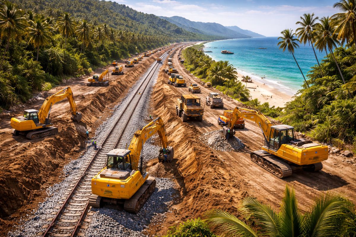
With an Investment of 1 Trillion Baht, the Thai Land Bridge Connects the Gulf of Thailand and the Andaman Sea with 87 Kilometers of Railway and Highway, Shortening Routes Through the Strait of Malacca, Promising Jobs but Threatening Fishermen, Durian Farmers, and Sensitive Mangroves in Southern Thailand in the Name of Regional Logistics Development
In 2018, the Thai government revived an old mega infrastructure plan: to connect the Gulf of Thailand to the Andaman Sea with 87 kilometers of railway and highway, deep-sea ports at each end, and an estimated investment of 1 trillion baht, equivalent to about 29 billion dollars or 177.80 billion reais. The official promise is to transform the country into a logistics shortcut capable of shortening maritime routes that currently depend on the congested Strait of Malacca by up to four days.
Throughout 2024 and 2025, public hearings and environmental studies began to detail the project’s impact on fishing villages, durian orchards, and extensive mangroves in southern Thailand, while Bangkok negotiates with foreign investors and plans to start construction of ports, railway and highway starting in 2026, within the Southern Economic Corridor, with a completion target by 2030. Amid billion-dollar figures and promises of growth, local communities speak of a rupture in ways of life and a new frontier for heavy industry in the region.
What is the Land Bridge of Railway and Highway in Thailand

The so-called land bridge project envisions two deep-sea ports, one in Ranong, facing the Andaman Sea, and another on the opposite coast, in the Gulf of Thailand, connected by a corridor of 87 kilometers of railway and highway with six lanes.
-
Video: Retiree builds 26-meter Roman castle in his backyard with pieces from dozens of countries, ornamental grates from Libya, and a dragon made of recycled metal.

-
Bricks made with recycled Styrofoam and cassava glue cost R$ 0.40 and insulate walls, reducing internal temperature by 6°C using a technique that produces 50 units with just one 50 kg bag of cement.

-
Scientists transform sawdust into fire-resistant panels, stabilize the compound with an enzyme extracted from watermelon seeds, and turn waste into promising material for construction.

-
Forget concrete: architects are replacing tons of concrete with giant blocks of expanded polystyrene to build the roofs of houses and reduce structural weight by up to 50%, cut costs, improve thermal insulation, and speed up construction.


The idea is to create a kind of Suez Canal on land, allowing containers to be unloaded from ships in one sea, cross the isthmus by train or truck, and continue their journey on the other side.
In practice, Thailand is trying to position itself as a physical link between the Pacific and Indian Oceans, reducing dependence on the routes that cross the Strait of Malacca, one of the most congested bottlenecks in global trade.
Official studies cited by the government point to projected capacity comparable to major Asian hubs and estimate a reduction of up to four days in travel time between Chinese ports and destinations in South Asia and beyond.
How Much Does It Cost to Connect Two Seas with a 87-Kilometer Railway and Highway

The estimated budget is around 1 trillion baht, about 29 billion dollars, distributed among the construction of ports, logistics complexes, intermodal terminals, and the combined layout of railway and highway.
The project is the anchor of the Southern Economic Corridor, a public policy aiming to elevate Thailand to the status of a high-income country by 2030, promising a 1.5 percent increase in GDP and thousands of new jobs.
This infrastructure is not limited to shortening maritime routes.
The government’s plan includes industrial zones, logistics parks, warehouses, and areas for processing high-value agricultural products, such as palm oil, fishing, and halal foods.
The land bridge is presented as the axis of a regional economic transformation, where the railway and highway serve as the backbone of a continuous industrial corridor.
Fishermen See Threats to the Bay and Their Way of Life
In Ranong, a port city historically dependent on tin mining and now reliant on fishing and mangroves that may seek UNESCO World Heritage status, enthusiasm for the project is far from unanimous.
Ao Ang Bay, an area of crystalline waters expected to host part of a deep-sea port covering over a thousand hectares, is at the center of concerns.
Artisanal fishermen, including Muslim communities and thousands of stateless individuals who rely on daily catches of crabs and mullet, fear that their fishing areas will be reduced by landfills, dredging, and increased traffic associated with the new railway and highway.
Local leaders point to the risk of sediment alteration, impacts on fragile ecosystems, and loss of physical access to the bay.
In the view of some of these families, the promise of development comes with the possibility of “dying alive” as they are prevented from going to sea.
Durian Farmers Fear Losing Roots to Make Way for the Highway
On the other side of the layout, farmers in the Pato district of Chumphon province see the line of the future railway and highway cutting through durian orchards valued as true “green gold.”
One single mature tree can yield around 50,000 baht per year, enough to support entire families in the region.
Although the government promises compensation for affected properties, farmers claim that no compensation can replace the time needed to grow a mature orchard and the security of an established business.
At the same time, they express concern over the advance of foreign investors, especially Chinese ones, who already dominate part of the local fruit purchasing market and may directly benefit from the new railway and highway for export.
For these farmers, the megaproject increases the risk of economic neocolonialism in lands currently occupied by small producers.
Pipeline Parallel to the Railway and Highway and Accusations of Greenwashing
In addition to containers and agricultural cargo, official documents indicate that the logistics corridor will include a pipeline running alongside the highway near Pato, positioning Thailand as a transit route for oil and gas from the Middle East to major consumers in China and Japan.
A study cited by provincial authorities estimates a potential revenue of 18 million baht per day just from fuel movements.
At the same time, the government offers carbon credits to investors through mangrove conservation projects, even in areas affected by the land bridge.
Environmental activists label this strategy as “greenwashing,” arguing that it makes no sense to sell an image of ecosystem protection while simultaneously concentrating, alongside the railway and highway, infrastructure for pipelines and conventional high-impact industries.
Fragmented Environmental Studies and Communities in the Dark
Local monitoring organizations, such as ecological awareness centers operating in Ranong and Chumphon, criticize how Environmental and Health Impact Studies have been conducted.
According to these groups, the reports are fragmented, analyzing ports, sections of railway and highway, and industrial zones separately, without presenting the public with a complete picture of the megaproject.
Public hearings held in 2024 indicated majority support among residents living within a restricted radius of five kilometers from the future ports, but community leaders point out that this cut ignores fishing and agricultural communities situated further away, directly impacted by route changes, sediments, pollution, and real estate speculation.
For these critics, the government offers a mosaic of partial information instead of a complete picture of the accumulated impacts.
Timeline of the Land Bridge and the Risk of an Irreversible Corridor
Impact assessments related to the land bridge are scheduled for 2025, alongside the processing of legislation that formalizes the Southern Economic Corridor.
The Thai government itself is working with a scenario to start construction of ports, railway and highway the following year and complete the entire infrastructure by 2030, consolidating a new permanent logistics axis in the south of the country.
Environmentalists and parts of local communities see this timeline as a crossroads.
On one side, Thailand is trying to accelerate investments in conventional industry and heavy logistics to compete for global cargo.
On the other, it is forgoing alternatives based on renewable energy, ecological tourism, and high-value agriculture, anchored in ways of life such as artisanal fishing and durian cultivation.
If the project advances in its entirety, the railway and highway corridor may become an irreversible scar on the southern coast, with concentrated benefits and costs spread over decades.
In your opinion, should Thailand prioritize the land bridge with 87 kilometers of railway and highway to become Asia’s logistics shortcut, or should it slow down the project and invest in less aggressive development models for fishermen, farmers, and mangroves in the south of the country?


-

-

-

-

-

8 pessoas reagiram a isso.