 Portuguese
  English
  Spanish
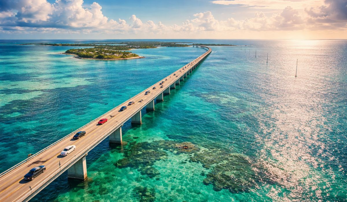
An old railroad transformed into a highway over the sea, with bridges, islands, and coastal landscapes, made the Overseas Highway one of the best-known routes in Florida and an essential link between the mainland and Key West.
Overseas Highway links mainland Florida to Key West
The Overseas Highway, a section of U.S. 1 that crosses the Florida Keys to Key West, originated from the adaptation of an old railroad and became the main land connection between the southernmost point of mainland Florida and the archipelago.
Along the route, the road crosses 42 bridges over channels and arms of the sea, in a roadway corridor surrounded by water for much of the journey.
Today, the route is also one of the main tourist axes in the region.
-
The dark underground world that exists beneath the Twin Cities of Minnesota.

-
Argentina enters the phase of the receiver network in Patagonia and Antarctica to monitor the far south, while Brazil keeps an eye on the South Atlantic and spreads sensors over 5.7 million km² of the Blue Amazon and reinforces its maritime sovereignty.

-
Goodbye disposable batteries: an item still consumed in 1.2 billion units per year in Brazil has a rechargeable alternative that can be used up to 1,000 times and reduces household expenses.

-
Millions of people have been eating mushrooms for millennia without knowing that this discreet food contains ergothioneine, an antioxidant that scientists now associate with memory protection and healthier aging.

Origin of the road in the Florida Keys
The origin of the highway dates back to the early 20th century when businessman Henry Flagler advanced the Overseas Railroad, a railway extension of the Florida East Coast Railway inaugurated to Key West in 1912.
The project connected islands and coastal areas in a region marked by long stretches of sea, reefs, and climatic instability.
The railroad, however, suffered severe damage in the Labor Day hurricane of 1935, which hit parts of the central and lower Keys.
After the destruction, the corridor was sold to the state of Florida and Monroe County.
The existing base was then adapted for road use, a process that resulted in the opening of the Overseas Highway in 1938.

As a result, the road inherited part of the layout and structures of the old railroad.
Instead of tracks, the route began to accommodate vehicle traffic, consolidating a permanent link between southern Florida and the islands.
Even today, historic sections and old bridges help explain the origin of the highway.
How the highway over the sea is formed
Although often described as a road that “crosses the ocean,” the Overseas Highway actually progresses through a sequence of islands, channels, and maritime areas of the archipelago.
The most well-known section is 113 miles, equivalent to 181.9 kilometers, between Key Largo and Key West.
Along this route, the highway connects successive keys through 42 bridges, which explains the feeling of driving over water.
Among these structures, the most famous is the Seven Mile Bridge, located in the central Keys.
The bridge has become the most associated image with the route for crossing an open stretch, with wide visibility of the surrounding waters.
The current structure replaced the old railroad bridge, which remains as a historical reference in part of the local landscape.

Function of the highway for residents and tourism
In addition to its tourist function, the highway plays a central role in the region’s mobility.
In much of the Keys, it serves as the main land axis for the movement of residents, circulation of goods, and access to services.
Public documents from Monroe County also address the capacity of the Overseas Highway as a relevant point in evacuation plans during extreme weather events.
Stops along the Overseas Highway
Along the way, the route includes stops that help explain the environmental and historical diversity of the archipelago.
In Key Largo, for example, the John Pennekamp Coral Reef State Park is one of the most well-known spots.
The park is recognized by Florida’s state park system as the first underwater park in the United States and includes areas of reefs, mangroves, and seagrass beds.
Further south, the region of Big Pine Key is home to the National Key Deer Refuge.
Established in 1957, the refuge protects habitats for local wildlife, including the Key deer, a species associated with the islands of the region.
In this section, the journey often requires extra attention to signage and speed limits due to the presence of animals.
Another frequent stop is the Bahia Honda State Park, an area known for its beach, trails, and remnants of the old railroad.
According to the state park, walking along the Old Bahia Honda Bridge offers a wide view of the waters and allows observation of part of the historical structure that was part of the old railway system.
At the end of the route is Key West, a city that concentrates the most urban and historical part of the journey.
It is there that the scenery of bridges and channels gives way to denser streets, a port, bars, museums, and old buildings.
The city serves as the final point for those traveling the road in search of the scenic crossing and the historical experience linked to the Florida Keys.
Best time to travel through the Florida Keys
For road tourism, the months of drier and more stable weather tend to see higher demand.
Still, the most objective data for planning involves the official Atlantic hurricane season, which runs from June 1 to November 30, according to NOAA and the National Hurricane Center.
Outside of this period, the likelihood of interruptions related to tropical systems tends to be lower, although the weather can vary at any time.
This factor is significant because the Overseas Highway does not function like a regular highway in a continental area.
Strong winds, heavy rain, construction, and slowdowns can alter the experience of those driving toward the islands.
Therefore, many visitors choose to start the journey early and better distribute stops along the route.
What to observe when driving on the Overseas Highway
In practice, the crossing requires constant attention from the driver.
At various points, the lane advances between water areas, reduced shoulders, and sections of heavy traffic, with the presence of tourists, residents, and service vehicles.
Driving requires careful reading of signage and respect for speed limits, especially in environmentally sensitive areas.
It is also necessary to consider that the road alternates between scenic segments and urban stretches, local accesses, and points subject to congestion.
The journey thus combines movement, historical memory, and coastal landscape in a single route.
In just a few hours, the driver leaves mainland Florida, crosses a chain of coral islands, and arrives at one of the state’s most well-known destinations.
Over time, the Overseas Highway has transitioned from an adapted corridor of the old railroad to a permanent link between islands, parks, bridges, and coastal cities.
The road combines historical importance, logistical function, and tourist appeal in a single route.


Seja o primeiro a reagir!