 Portuguese
  English
  Spanish
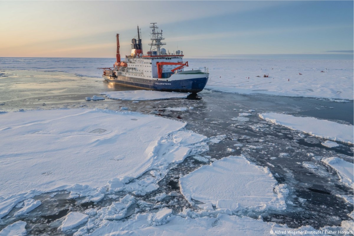
In the Weddell Sea, scientists from Polarstern find an island of 130 meters that was out of the correct position on nautical charts, revealing an error of nearly 1 nautical mile and forcing a revision of maps in Antarctica
A pause due to bad weather ended up revealing a rocky point that seemed just another dirty block of ice. What appeared before the crew was a real island, measuring 130 meters in length, 50 meters in width, and 16 meters above water.
The impact is direct for navigation in one of the most challenging areas of the planet. The position shown on the charts was displaced by about 1 nautical mile, a significant error in Antarctica and in a region with still limited measurements.
With 93 crew members on board, the research vessel Polarstern has been exploring the northwest of the Weddell Sea since February 8, 2026, a strategic area for understanding global currents, ice outflow, and recent retreat of sea ice.
-
Digital scams with artificial intelligence are becoming more sophisticated and harder to detect; see how criminals use AIs to deceive victims and discover effective strategies to avoid significant financial losses.

-
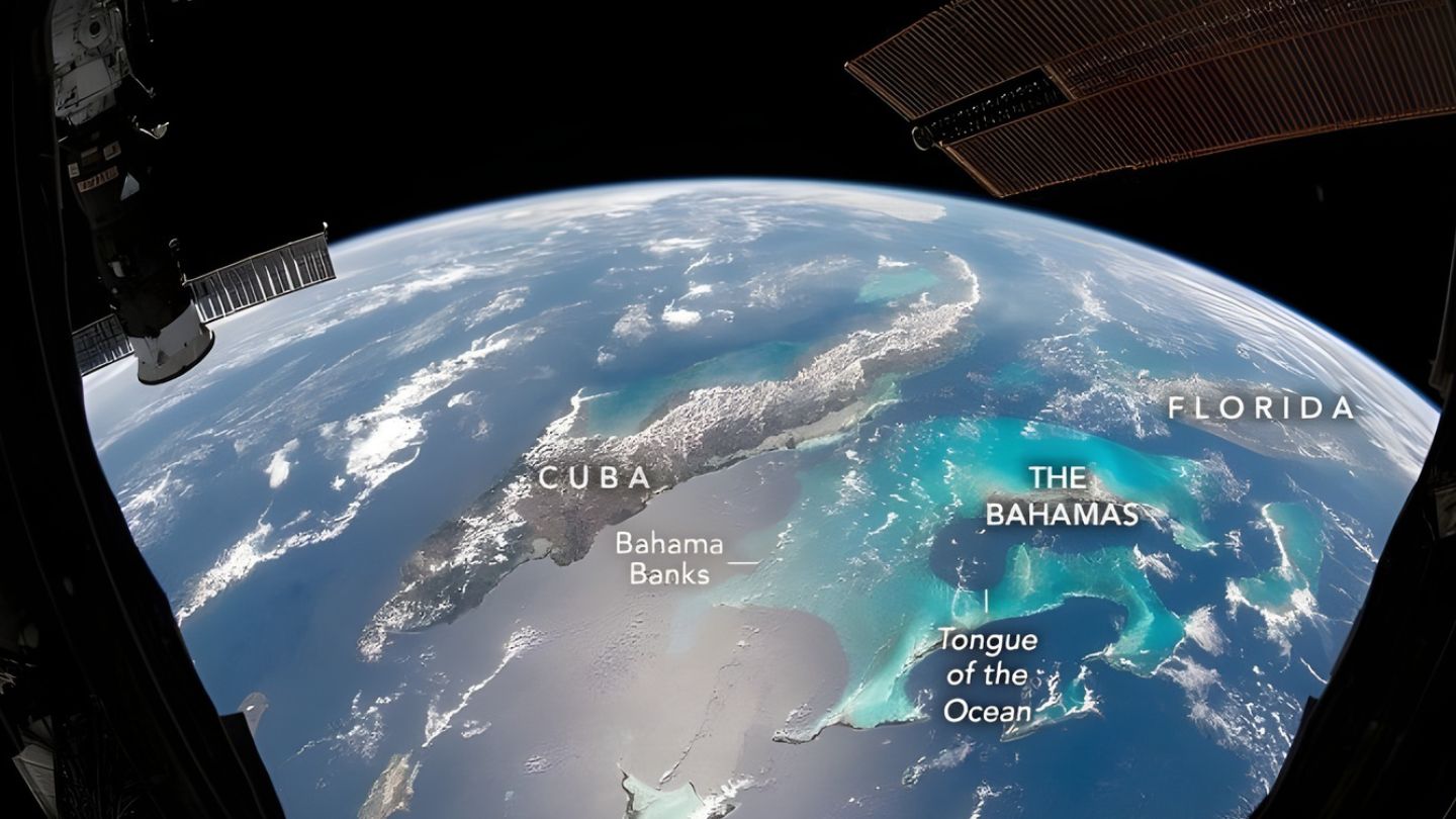
Photo taken by an astronaut on the ISS shows the Great Bahama Bank with turquoise waters only 2 meters deep visible from space, a region described as one of the most beautiful in orbit that was solid land about 20,000 years ago and drops 2,000 meters into the Tongue of the Ocean.
-
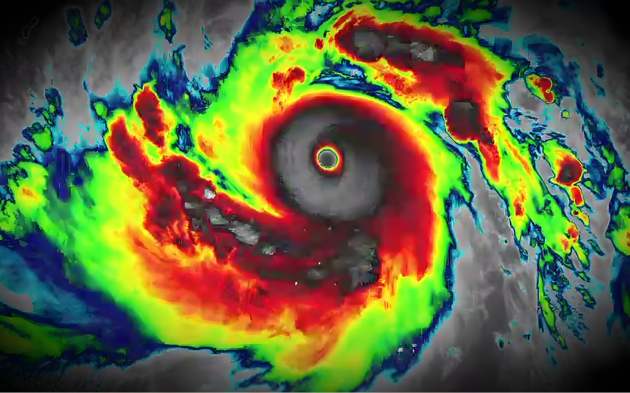
Super Typhoon Sinlaku reaches winds of 306 km/h in the Pacific Ocean and puts the Mariana Islands on high alert.
-
FBI issues urgent warning: end-to-end encryption does not prevent breaches and can expose messages even in the largest apps.

The island appeared when the ship sought shelter near Joinville Island
The discovery occurred at a moment when scientific work had to be interrupted due to rough seas. While seeking shelter downwind of Joinville Island, the team first saw what looked like a darkened iceberg and only later realized there was rock in the area.
The change of course was immediate. The further the ship advanced, the clearer it became that it was not drifting ice, but a small island that was not correctly depicted as coastline on the available maps.
The approach reached 150 meters with at least 50 meters of water below the hull

The navigators brought the Polarstern in with extreme caution until it was 150 meters from the point, always keeping 50 meters of water under the keel. This detail shows the level of care taken to confirm what was before them.
After that, the ship circumnavigated the entire island and measured the seabed with onboard sonar. A drone was also used to generate an accurate aerial image and an elevation model that allowed for safer measurement of the coastline.
The map showed danger, but did not show the real coastline
According to Alfred Wegener Institute, a German polar and marine research center, the area appeared on the charts as a danger zone for navigation, but not as a coastline in other datasets. Additionally, the drawn position was about 1 nautical mile off the actual location.
This misalignment helps explain why the finding gained immediate significance. In satellite images, the ice cover made the island visually blend in with the surrounding icebergs, making it difficult to distinguish solid land from floating ice.
The numbers stand out in an area where only 25 percent of the seabed has been measured directly

The record gained extra importance because the issue involves not just an isolated rock. Today, just over 25 percent of the ocean floors on the planet have been mapped with direct measurements made by ships, while the rest still largely depends on indirect estimates.
In polar regions, this weighs even more. When data coverage is thin, unmapped objects can simply disappear from the models used to produce seabed maps and navigation support charts.
Official name and exact position still await international registration
The precise coordinate of the island has not yet been publicly disclosed. The publication is expected to occur after the naming stage, which is important for inserting the point into international nautical charts and other databases used in Antarctica.
This process also helps to show how Antarctic geography is organized. The international name bank for the region contains 39,187 names linked to 20,159 features, submitted by national committees from 22 countries.
This case does not concern an island that was just born, but rather an island that has finally been measured correctly. Even small, it exposes how a difference of just a few numbers can alter routes, cartographic bases, and scientific reading in an extreme area.
With 130 meters in length and position corrected after a close-range check, the finding shifts from detail to a warning signal for maps, expeditions, and polar navigation. It is a small discovery in size but large in effect, changing the strategic reading.


Seja o primeiro a reagir!