 Portuguese
  English
  Spanish
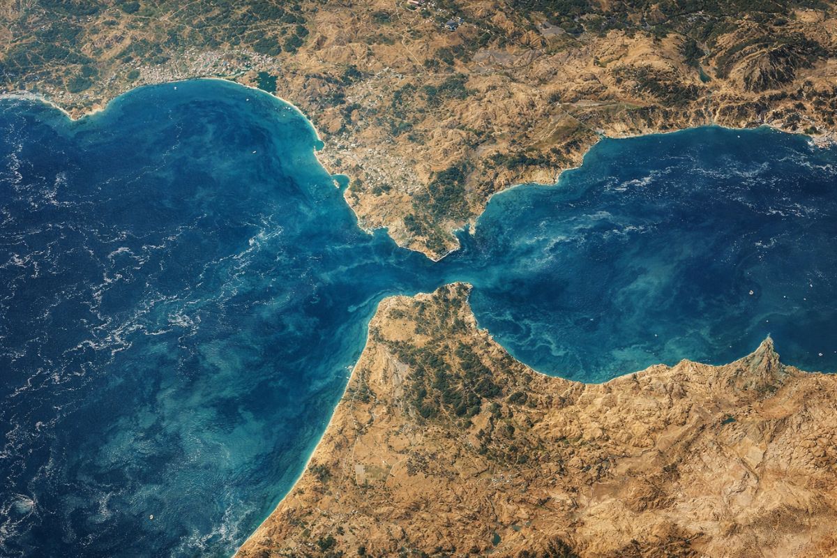


Spain and Portugal Are Rotating Clockwise Due to the Convergence Between Eurasian and African Plates, with Approach of 4 to 6 Millimeters Per Year. GNSS and Seismic Data Help Map Diffuse Boundaries, Point Hidden Faults, and Understand Why the Mediterranean Tends to Close in Millions of Years
Spain and Portugal are moving toward Africa at such a slow pace that it does not alter the map in anyone’s life today, but it is sufficient to rewrite the Mediterranean on a geological scale. The movement occurs in millimeters per year, and what seems “only theory” is already being measured with millimeter precision.
According to researchers from the University of the Basque Country, the central point is that Spain and Portugal do not follow exactly the same rotation pattern as the rest of Europe. The Iberian Peninsula rotates clockwise, and this is interpreted as the effect of tectonic convergence that pushes southwestern Europe toward a future of continental collision.
What Is Happening with Spain and Portugal and Why the Rotation Is Different

Spain and Portugal “dance” to the rhythm of a different continent because the Iberian Peninsula is rotating clockwise.
-
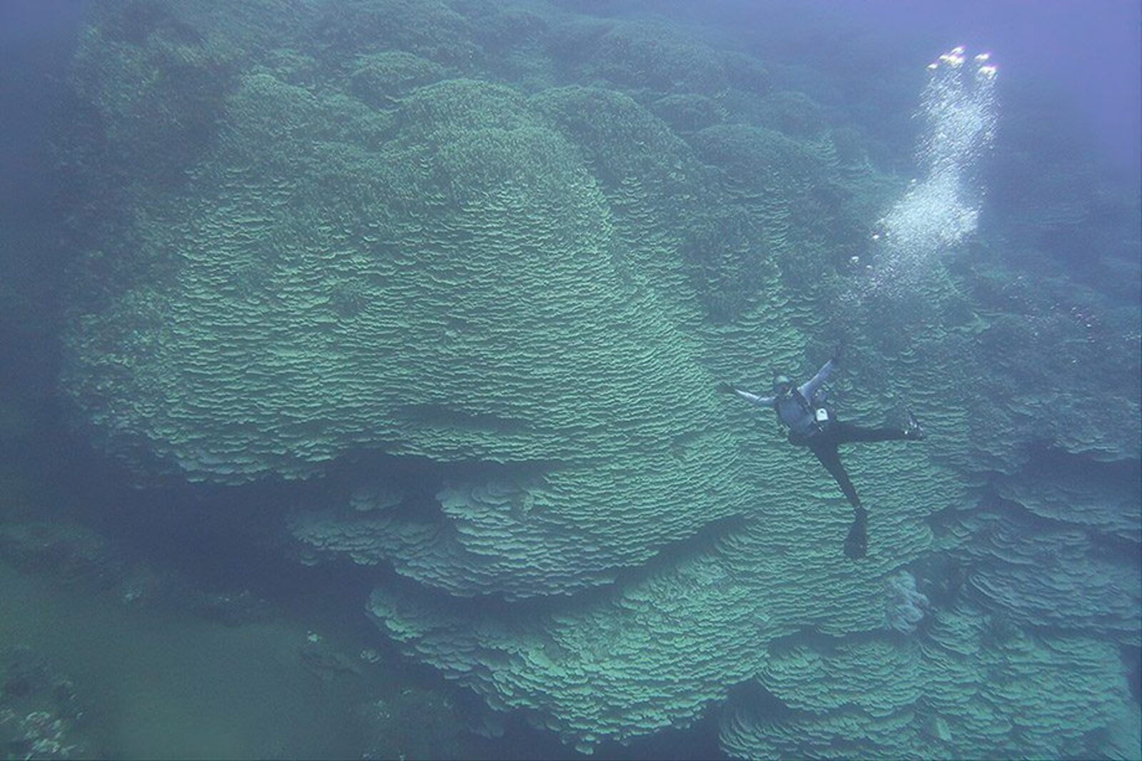
At the bottom of the sea, scientists have found a true underwater cathedral measuring 62 meters at the base, 31 meters at the top, and 1,347 square meters of giant coral in the Maug Islands, estimated to be 2,050 years old.
-
Surrounded by the sea, the airport will have a system to prevent airplanes from falling into the water; technology will be installed in Ilhéus (BA), with an investment of R$ 70 million.

-
With a cost per shot close to zero, the DragonFire laser could change naval warfare in 2027 and provide British ships with nearly unlimited defense against drones.

-
A British startup creates tires that generate electricity in electric vehicles when passing over potholes, speed bumps, and cracks.


This rotation is described as a process from east to west, which does not mean immediate separation from the rest of Europe, but distinct behavior compared to neighbors that present counterclockwise rotation, such as Italy and the Anatolian Plate.
The tectonic reading behind this is straightforward: Spain and Portugal are in the zone of influence of a diffuse boundary between plates, where there is no single, clear limit as in other regions.
When the boundary is diffuse, the movement is distributed in subtle deformations, and it is precisely this type of deformation that makes the displacement seem invisible on the surface.
The Convergence of 4 to 6 Millimeters Per Year and the Role of the Gibraltar Arc
The engine of the displacement is the convergence between the Eurasian and African plates, with an estimated approach of 4 to 6 millimeters per year.
This figure is not new as a concept, but the cited study reinforces the interpretation that this push is associated with a consistent rotation of the Iberian Peninsula.
This is where the Gibraltar Arc comes in, which acts as a tectonic buffer east of the Strait.
The logic described is as follows: to the east, part of the deformation is “absorbed” by the Gibraltar Arc; to the west, a more direct collision occurs, with less damping.
It is this asymmetry that helps explain why Spain and Portugal rotate clockwise, instead of repeating the pattern of other areas on the continent.
How GNSS and Seismic Data Measure a Movement That Nobody Feels
To detect something that moves a few millimeters per year, the research combined two independent sets of evidence.
On one side, satellite deformation with GNSS, using permanent and temporary GPS markers to measure surface displacements with millimeter precision.
On the other, recent earthquake data were analyzed, which helps infer where the crust is accommodating stress and which structures are active.
The strength of the method lies in the combination: when GNSS and seismicity point to the same pattern, the boundary between plates ceases to be “hypothesis” and becomes operational mapping, with immediate implications for risk.
What Does This Change Today: Hidden Faults, Stress Zones, and Earthquake Forecast
The highlighted practical effect is not “the map will change,” but that Spain and Portugal gain a better map of what is active beneath their feet.
By outlining more clearly where direct collisions occur and where deformation is absorbed, researchers indicate where to look for active or potentially active faults that have not yet been identified.
This utility appears in areas mentioned such as the Western Pyrenees and the Cádiz and Seville region, where it is already known that there are significant deformations, but the causative structures are not always well defined.
When the structure is identified, the discussion moves from generic fear to a scenario of magnitude, event type, and urban planning, even without any visible change on the coast.
The Future of the Mediterranean: Slow Closure, Acceleration, and a New Continental Configuration
The final consequence, on the geological horizon, is that Spain and Portugal may unite with North Africa, with Morocco forming a unit with the Iberian Peninsula.
The text describes that the continental collision could close the Mediterranean but emphasizes that this is a long process, estimated to take tens to hundreds of millions of years.
The time cited for the collision is on the order of 100 million years, with the idea that the current pace may be maintained for about 20 million years and accelerate around 50 million years, transforming the region into one of the most volcanically and seismically active areas on the planet.
It is a future too distant for everyday anxiety, but close enough to justify applied science in faults and seismic risk now.
Spain and Portugal are moving toward Africa in an almost invisible movement, measured at 4 to 6 millimeters per year, and the clockwise rotation is linked to plate convergence and the effect of the Gibraltar Arc.
The Mediterranean does not “close” tomorrow, but the process is already helping to reshape knowledge about faults, boundaries, and stress zones in southern Europe.
I want a comment with personal experience: if you live, have traveled, or have studied the region, which place do you think should have more intense monitoring, Cádiz, Seville, Western Pyrenees, or the area near the Strait of Gibraltar, and for what concrete reason?


Qué desgracia, unirnos a África y cerrarse el mediterráneo. En vez de alejarnos, que sería lo conveniente, se nos echa encima. Ya es desgracia, ya.
Desafortunado el que escribio el comentario🤭
100 milhoes de anos para unir Espanha, Portugal e Marrocos, voce nao tem esse tempo todo, para Salvar A SUA ALMA, ACEITEM A JESUS, igreja Universal
Lembrei do livro de Saramago “A jangada de Pedra” kkkk. Nele o autor usa de forma metafórica um deslocamento de placas que separa a Península Ibérica da Europa, uma espécie de “alusão cultural e socioeconômica de “exclusão” dessa região em relação ao restante da Europa.