 Portuguese
  English
  Spanish
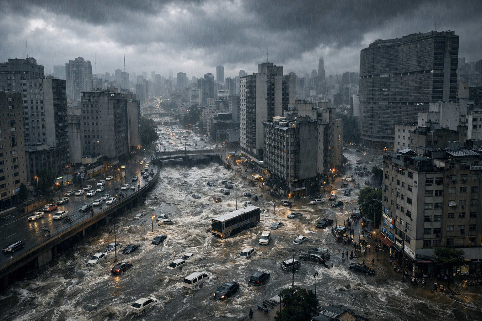


How Historical Choices Transformed a City Between Rivers Into an Impermeable Territory
It only takes a few hours of rain for São Paulo to come to a standstill. Streets turn into rivers, the subway halts operations, houses are flooded, and the television helicopter takes to the skies to record yet another chapter of a problem that repeats itself year after year. The most alarming aspect, however, is that extreme storms are not necessary. A moderate rain is enough to isolate entire neighborhoods and expose an urban collapse that has been building for centuries.
This information was released by the channel Elementar, academic studies, and analyses by urbanism specialists, in addition to public data gathered by projects like MapBiomas and interviews granted by professors from USP and Unifesp, which help explain why the city of São Paulo floods so often — and why the problem seems to worsen over time.
To understand the present, we must go back to the past. São Paulo was founded in the 16th century, literally between rivers. The Jesuits chose a high point, surrounded by the then-navigable Piratininga River — now known as Tamanduateí — and the Anhangabaú stream, which was described at the time as clean and suitable for supplying and washing clothes. This geographic privilege, however, quickly turned into a headache.
-
China retires the J-7 fighter after years of military protection and can now transform military items into drones, following more than 60 years of operation of the J-7, derived from the MiG-21, with thousands of units produced and strategic use in the PLAAF and PLANAF.

-
Volunteers are sought to live in the mountains for a month: a study pays people to stay at 2,500 meters, with 24-hour monitoring of sleep, metabolism, and blood pressure.

-
Goodbye to kitchen cabinets: innovation retires the traditional furniture of Brazilian kitchens by introducing modern pantries with modules of up to 2.40 m, 40% more organization, ergonomic access, adjustable shelves, and smart lighting in 2026.

-
After the union of Brazil and China, BRICS plays a leading role in the merger between two powers: Egypt and India move forward with agreements exceeding US$ 4 billion, expanding industrial capacity in strategic sectors and accelerating the establishment of factories and global production chains.


As the city grew, its floodplains began to be occupied. Floodplains are natural plains where the water from rivers spreads during floods. Ignoring this dynamic was the first major mistake. Records of floods in São Paulo date back to before 1840, when the Tamanduateí was already flooding entire neighborhoods. To maintain circulation, the solution was to improvise: bridges, ditches, and channels emerged without an integrated strategy.
In 1841, the first formal drainage and landfill project emerged, precisely in the area where Rua 25 de Março is located today. Like many public works in Brazil, it took about 10 years to be executed. Even so, in 1887, the city faced one of the largest floods at that time. Reports from the period recorded that, in the Tietê River, the water reached a level of 8 meters, covering the pavement of almost all adjacent single-story houses.
Even with sporadic drainage works and reservoirs, São Paulo continued to grow without planning. By the end of the 19th century, floods had become routine. Warehouses and industries took over the banks of rivers, disrupting the natural balance of the floodplains, which function as secondary beds for periodic flooding. What was once water territory turned into concrete territory.
Buried Rivers, Avenues Over Streams, and the Rupture of Natural Balance

In the early 20th century, a battle of ideas defined the fate of São Paulo’s rivers. Engineer Francisco Saturnino de Brito advocated for preserving the banks of the Tietê and Pinheiros as large linear parks, with areas for natural infiltration and urban breathing space. His proposal envisioned parks over a kilometer wide along the banks, integrating leisure, drainage, and environmental preservation.
However, the opposing vision prevailed. The Avenue Plan, designed by Prestes Maia, opted for the canalization and rectification of rivers, covering them with the major thoroughfares that now structure the city, such as the marginal roads, Avenida do Estado, 23 de Maio, and Nove de Julho. São Paulo wanted to become the “Chicago of South America” and chose to bury its rivers, considered “foul and putrid,” beneath layers of asphalt.
This is how the so-called ghost rivers were born. Researcher Maurício Ayer, author of the article “The Buried Rivers of São Paulo,” describes one of them as “a dead river,” nameless, history-less, and without divinity, buried under Avenida Hélio Pellegrino. Even buried, the river continues to flow, albeit invisibly, like an urban ghost.
As concrete advanced, floods became more frequent. The canalizations and rectifications of the Tamanduateí, Pinheiros, and Tietê Rivers profoundly altered the hydrological condition of the Upper Tietê Basin. Water began to flow faster, without absorption areas, increasing the volume and speed of floods.
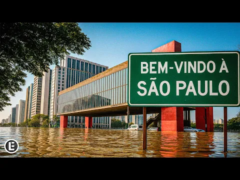
Today, according to data from the Annual Mapping Project of Land Cover and Use in Brazil, MapBiomas, 57% of the surface area of São Paulo city is covered by concrete, asphalt, and roofs. In 1985, this figure was 52%. In just three decades, the city became even more impermeable. When water cannot infiltrate, it does what it has always done: it runs to the lowest points, but now without drainage, without outlet.
Extreme Climate, Old Infrastructure, and the Human Cost of Recurring Floods
In addition to urban decisions, the climate has exacerbated an already fragile system. Professor Pedro Côrtes from USP explains that São Paulo’s drainage system was designed for a more predictable subtropical climate, with rain distributed throughout the year. Today, the pattern has changed. Storms are rapid, concentrated, and much more intense.
According to the professor, there is an increase in the annual volume of rainfall, but concentrated over a few days. The result is simple: an old, narrow, and poorly maintained infrastructure cannot cope. Many stormwater drains are over 40 years old without renovation. Clogged storm drains, silted galleries, delayed works, and poor maintenance worsen even light rains.
Another critical factor is garbage. São Paulo generates more than 20,000 tons of waste per day, and part of this material ends up in storm drains and streams, blocking water drainage. The cycle repeats itself every year.
When the system collapses, the impact is unequal. The peripheries are always the most affected. In February 2025, Jardim Pantanal was submerged for seven days. About 45,000 residents were affected, hundreds of families were displaced, and the estimated cost was R$ 1.9 billion in compensation and popular housing.
Professor Kazuo Nakano from Unifesp warned that São Paulo shows clear signs of collapse in its drainage system, as the works have never followed urban growth or the new climatic reality. During this episode, streets turned into channels and residents improvised crossings.
Despite this, Mayor Ricardo Nunes stated that the city was “very prepared” to deal with climate events and that the impacts could have been worse without the interventions made. The statement drew criticism, especially because a day earlier, the city faced the third heaviest rain in its recent history. People were trapped in the subway, had to hold onto railings to avoid being swept away by the current, and an elderly man died after a flood broke the wall of his house, creating a two-meter wave in the yard.
The numbers reinforce the gravity. In 2016, 25 people died after a night of heavy rain, many in landslides. In March 2019, at least 12 deaths were also recorded due to the rain. These episodes highlight a problem that is not just climatic but also a matter of management and fragmented urban planning.
Currently, the municipality spends about R$ 336 million annually just on emergency actions post-flood. Each major flood generates approximately R$ 762 million in losses to the national economy, adding losses in commerce, transport, and productivity.
The city’s main bet remains the big reservoirs. There are 55 in operation and another 8 under construction, with a total capacity of 853,000 cubic meters, equivalent to more than 340 Olympic swimming pools. The investment was R$ 1.6 billion in the last four years. Despite this, as Maurício Ayer points out, the city tries to “exorcise its dead rivers with reservoirs,” treating only the symptoms, not the root of the problem.
Initiatives such as the Tietê Ecological Park and the Tietê Floodplain Project partially restore the natural function of the floodplains, acting as sponges that absorb billions of liters of water. Nature-based solutions, such as permeable sidewalks, green roofs, and the Green IPTU, are also gaining ground, but still on a limited scale.
Meanwhile, the lack of coordination between drainage, housing, and transportation policies continues. With the end of bodies such as Emplasa, São Paulo lost its capacity for integrated metropolitan planning. Each municipality acts in isolation.
International experiences show that another path is possible. In Seoul, the Cheonggyecheon River was uncovered after decades and transformed into a linear park, reducing floods and revitalizing the center in just four years. In São Paulo, the movement Rios e Ruas has already mapped more than 800 buried waterways, reminding us that what the city tries to erase, nature insists on revealing.
Ultimately, as long as São Paulo insists on fighting against water, it will continue to lose to it. The rivers remain alive beneath the concrete, and with each heavy rain, they return to remind us that they were never gone.


População tbm que não tem educação,jogam tdo que é tipo de entulho nos rios,casas que constroem nas beiradas dos rios,que prefeitura não devia deixar,enfim é um conjunto de coisas que acontece estas enchentes,não é só culpa do governo
Não precisa ser engenheiro para saber que não pode ignorar os rios , não pode construir nas margens. Enfim estudam tanto para que?