 Portuguese
  English
  Spanish
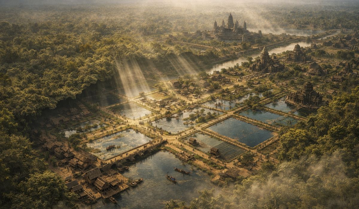
Under The Forest Of Cambodia, LiDAR Exposed The Urban Scale Of Angkor And Revealed How Canals, Reservoirs, And Roads Structured A Medieval Metropolis Of Large Dimensions, Redrawing What Researchers Understand About The Power And Organization Of The Khmer Empire.
From above, the forest in northwestern Cambodia still suggests a territory marked by isolated temples and dense vegetation.
Aerial mapping with LiDAR, however, revealed another scale for Angkor.
Under the tree canopy, canals, dikes, reservoirs, roads, and residential areas appeared that integrated a system used to sustain a population of hundreds of thousands at the height of the Khmer Empire.
-
A person became a millionaire with just a 10-hour video of a lit fireplace on YouTube.

-
The Finnish armored vehicle Patria AMV 8×8 with eight wheels stands out with mine protection, advanced armor, modular design, and high mobility in military operations that redefine modern combat.

-
Workers manually excavate 6 million kilograms of ice to open a cave that allows observation of how a glacier is melting from the inside.

-
Archaeologists find a colossal 2,000-year-old vessel at the bottom of the sea near Alexandria linked to the elite of Egypt and reveal a pleasure barge from the last dynasty of the pharaohs that the sea has hidden for centuries.


Based on this surveying, researchers began to classify the region as the largest pre-industrial urban complex ever identified.
LiDAR In Angkor Revealed The Scale Of The Hidden City
The change in perspective occurred in 2012, when archaeologist Damian Evans and his team conducted an aerial LiDAR survey over 370 km² of northwestern Cambodia.
The technology emits laser pulses capable of penetrating vegetation and recording the surface of the terrain with a high level of precision.
In about 20 hours of flight, the method allowed for the identification of landforms and structures that remained hidden under the forest.
Digital terrain models revealed a more extensive urban landscape than suggested by the known monuments alone.
In addition to the large temples, regular patterns of occupation, roads, dikes, canals, and evidence of organized neighborhoods emerged.
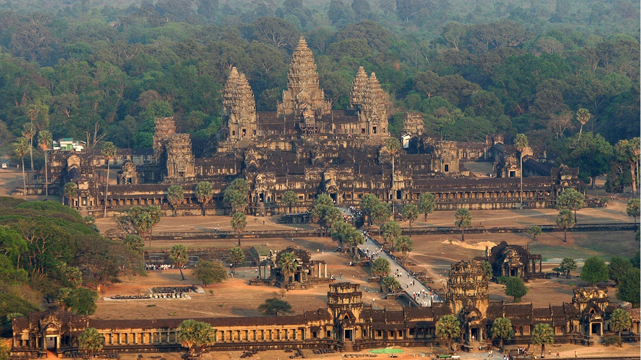
The study published in the journal Proceedings Of The National Academy Of Sciences in 2013 described a planned area that articulated monuments, hydraulic infrastructure, and human settlements within the same territorial logic.
The understanding of the archaeological site changed from this data.
Instead of a set of sanctuaries surrounded by vegetation, Angkor came to be understood as a large-scale urban network spread over approximately 1,000 km².
This territorial dimension, associated with hydraulic engineering, supports the assessment of part of the specialized literature that it was the largest urban complex in the pre-industrial world.
Mahendraparvata And Other Cities Of The Khmer Empire
One of the most relevant results of the survey was the material confirmation of Mahendraparvata, the political center of the early Angkorian period associated with the reign of Jayavarman II, consecrated in 802.
The city was already known from inscriptions and historical references, but its urban form remained undefined.
With LiDAR, avenues, temples, and hydraulic structures began to emerge on the Phnom Kulen plateau, indicating a planned settlement on a larger scale than previously assumed.
The discoveries expanded in the following years.
A new survey, released in 2015 and detailed in subsequent research, expanded the archaeological map of the Angkor region and other Khmer centers.
At Preah Khan of Kompong Svay, a monumental complex located east of Angkor, remote sensing also identified a medieval urban grid of large proportions.
For researchers, this data indicates that the territorial and hydraulic organization of the Khmers was not limited to the most well-known capital.
Population Of Angkor At The Peak Of The Khmer Empire
The size of Angkor’s population remained surrounded by uncertainty for decades.
In 2021, a study published in Science Advances combined three decades of excavations, LiDAR data, and computational modeling to estimate the population of Greater Angkor over time.
According to the authors, at its height, around the 13th century, the region housed between 700,000 and 900,000 inhabitants.
This contingent helps to gauge the importance of the hydraulic infrastructure.
Angkor depended on a system capable of storing, distributing, and redirecting water between dry periods and monsoons.
At the same time, the population did not live concentrated only in the monumental stone areas.
Many residents occupied wooden houses and other perishable materials, built on mounds along canals, roads, and irrigated fields.
The residences disappeared over time, but the artificial mounds and patterns of occupation remain visible in the topographic models.
West Baray And The Hydraulic Engineering Of Angkor
At the center of this system were the barays, large rectangular reservoirs associated with royal power and the agricultural functioning of the region.
The most well-known of them, the West Baray, measures approximately 7.8 km long by 2.1 km wide.
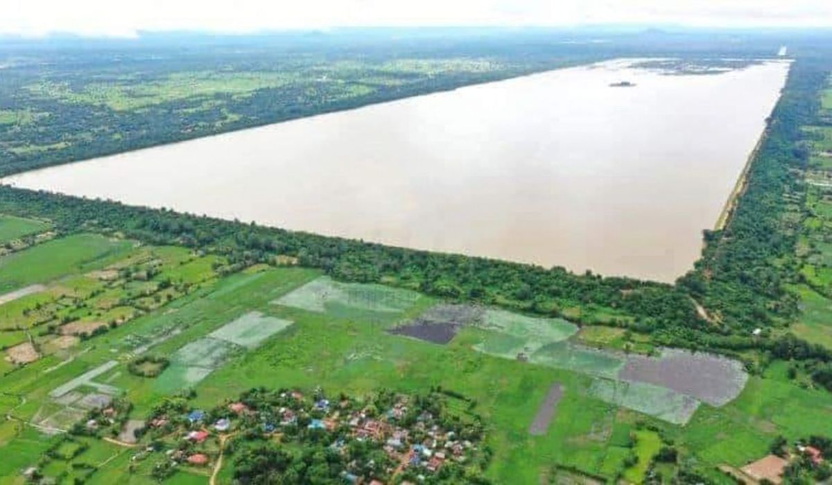
Its capacity is estimated at around 53 million cubic meters, contained by earthen dikes that reach nearly 12 meters in height.
According to studies cited in archaeological literature, it is one of the largest manually excavated reservoirs ever recorded.
Water was conducted through channels and redistributed as needed, especially for rice production in the plains around the city.
Archaeological and geomorphological research indicates that this system was not limited to an isolated reservoir.
There was an articulated network of large barays, smaller tanks, supply channels, and drainage channels, all integrated into the urban and agricultural dynamics.
Therefore, experts treat Angkor not only as a city with hydraulic works but as a space organized around water control.
Climate Change And The Weakening Of Angkor
This same infrastructure, however, showed signs of vulnerability when the climatic regime changed.
In 2010, a study led by Brendan Buckley, published in PNAS, reconstructed about 759 years of hydroclimatic variation from the growth rings of trees in present-day Vietnam.
The data indicated two prolonged megadroughts between the 14th and 15th centuries, interrupted by very intense periods of rain.
According to the researchers, this extreme alternation pressured the Angkorian water network.
Instead of a sudden collapse, the hypothesis proposed by studies is one of a gradual process of wear.
The prolonged drought reduced water availability and compromised maintenance.
Later, exceptional monsoons amplified erosion, siltation, and ruptures in critical sections of the network.
A study from 2018, also based on modeling, indicated that floods above certain thresholds could cause cascading damage, with cumulative effects on urban infrastructure.
This scenario does not alone explain the loss of centrality of Angkor, but is pointed out by researchers as one of the factors helping to understand the weakening of the Khmer capital at the end of the medieval period.
In 1431, Ayutthaya forces took Angkor in a context already marked by political and environmental changes.

World Heritage And The Archaeological Legacy Of Angkor
Angkor was inscribed on the UNESCO World Heritage List in 1992.
The archaeological park covers about 400 km², while the so-called Greater Angkor, considered in research on medieval urbanization, extends beyond the most visited monumental core.
The West Baray itself still stores water, which, according to experts, indicates the persistence of part of the functionality of this engineering centuries after its construction.
More than expanding knowledge about ruins hidden under the forest, LiDAR changed the scale at which Angkor began to be studied.
The images obtained through remote sensing showed that the area brought together temples, neighborhoods, roads, and hydraulic structures distributed across a landscape profoundly modified by human action.
Under the jungle, there was an infrastructure aimed at supply, agricultural production, and connection between political centers of the Khmer Empire.


-

-

3 pessoas reagiram a isso.