 Portuguese
  English
  Spanish
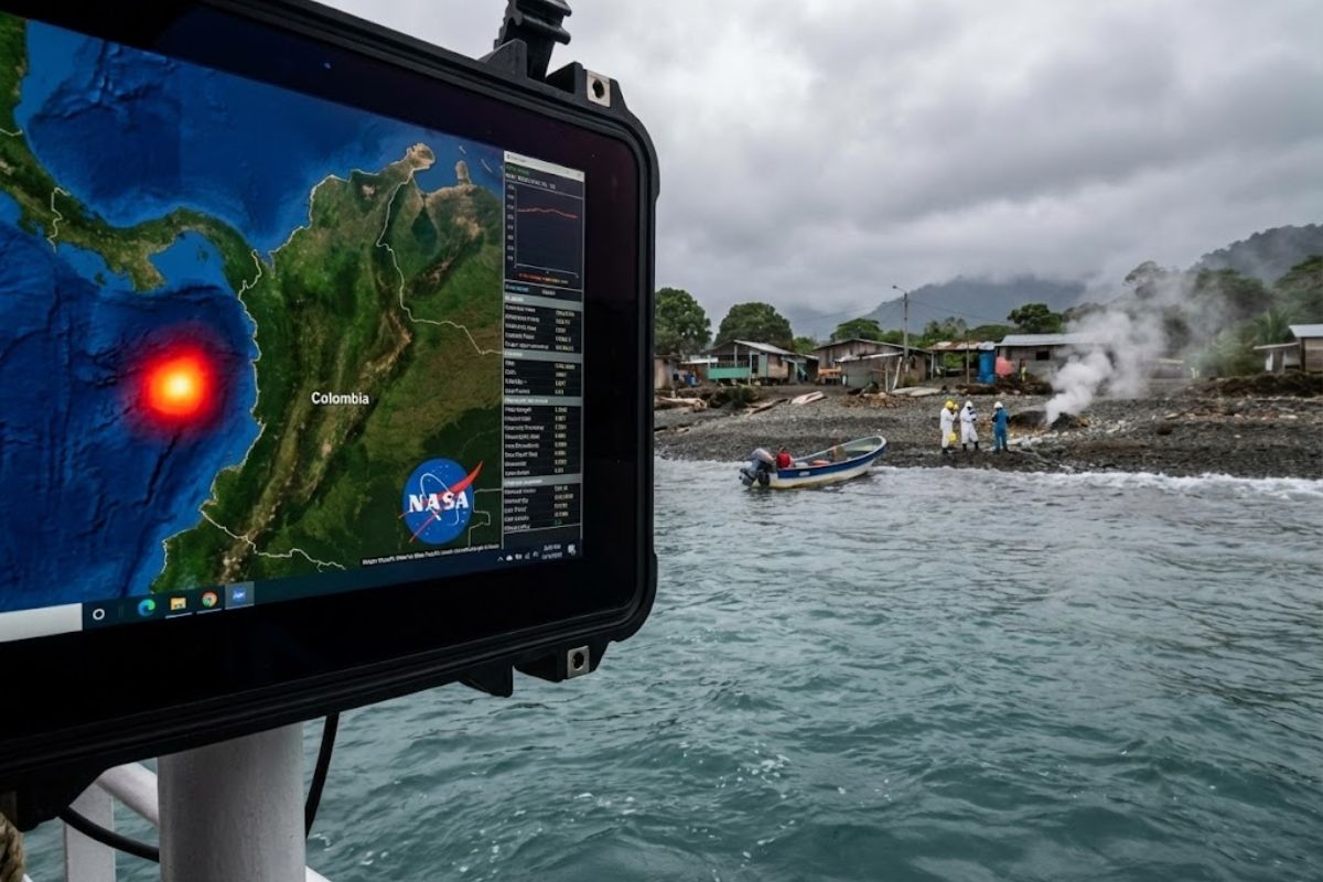
Thermal Images From NASA’s Terra Satellite Indicate Coastal Areas With Repeated Cycles of Abnormal Temperature Increases Associated With Sea Level Anomalies, Chlorophyll, and Soil Moisture Near the San Juan River in Chocó, Colombia. The Pattern Coincides With a Submarine Fault and Microflashes in the Jungle
The NASA has identified an unusual pattern in one of the most remote areas of Colombia, on the Pacific coast, after analyzing satellite images that show repetitive warming, changes in the sea, and subtle signs in the soil. The behavior does not appear as an isolated episode: it repeats, intensifies, and changes position.
The alert is focused on the Chocó region, near the mouth of the San Juan River, where sensors recorded thermal anomalies in specific coastal bands and small variations in sea level detected by altimetric instruments. Additionally, variations in chlorophyll were recorded, indicating changes in the marine ecosystem and alterations in land reflectance, as if the soil moisture were being modified from within.
What NASA Saw in the Terra Satellite Images
According to the analyzed material, the thermal images captured by the Terra satellite from the NASA at the end of last year should reflect the typical pattern of the Colombian Pacific: extreme humidity, stable temperatures, and dense cloud cover.
-
Scientists have finally discovered where the plastic that disappeared from the oceans went, and the answer is frightening: it fragmented into such tiny particles that they became invisible and now there are 27 million tons of nanoplastic just in the North Atlantic.

-
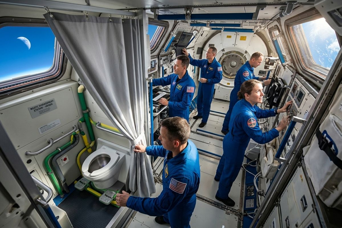
The Artemis II mission will take the Orion capsule back to the vicinity of the Moon with four astronauts, a private bathroom with a curtain, a system adapted for men and women, and a level of comfort that highlights how the Apollo era operated at the rawest limits of space exploration.
-
Giant structures on the seabed precisely control oil and reveal how high-tech underwater valves work.

-
China has just tested a giant drone the size of a fighter jet with a wingspan of 25 meters that carries 6 tons, flies for 12 hours, and the most frightening part: it can launch entire swarms of smaller drones directly from the air.


What appeared was different.
The NASA found bands of abnormal warming that repeat in cycles, described as coinciding with certain lunar calendar periods.
At the same time, altimetric sensors indicated discrete sea level anomalies close to the hottest point, suggesting a combined phenomenon between the atmosphere, ocean, and coastline.
Anomalies in the Sea, Chlorophyll, and Signs in the Soil
In addition to temperature, satellites also detected fluctuations in chlorophyll concentration in the water, which indicates a possible change in the marine ecosystem in the monitored area.
The same data set mentions subtle signs in the ground reflectance, interpreted as changes in soil moisture.
This detail is central to the reasoning presented: for the NASA, the pattern is not limited to the ocean.
It also appears at the interface between mangroves, sediments, and flooded areas, where the terrain is already unstable by nature, with rivers carrying material and slopes susceptible to landslides.
The Fit With an Ancient Submarine Tectonic Fault
When researchers cross-referenced the affected points with geological maps, the reading gained another layer: the anomalies would coincide with an ancient submarine tectonic fault, parallel to the Pacific coast, described as inactive for centuries.
From this intersection, the report states that the NASA cited, in a preliminary report, the possibility of a reconfiguration of seismic or hydrothermal activity beneath the region.
The sensitive point is that this type of behavior has not been documented in Colombia with the described characteristics, raising the level of attention for an unexplained subterranean process.
Microflashes in the Jungle and Competing Hypotheses
Another element mentioned is nighttime images with luminous microflashes in jungle areas far from any population.
These flashes would be weak, recurring, and difficult to explain, with hypotheses raised in the material itself, such as lightning without storms, piezoelectric activity, or gas release.
The NASA does not close the diagnosis in the report presented.
What exists is a set of signals that appear together, recur, and shift, creating a pattern that stands out precisely because it does not behave like an isolated anomaly.
Why the Colombian Pacific Is So Sensitive to Changes
The described scenario combines geographical isolation and extreme dynamics.
The coast of the Colombian Pacific is presented as one of the rainiest and most biodiverse regions on the planet, with rain on more than 300 days a year and precipitation exceeding 12 mm annually, in an environment of mangroves, swamps, steep hills, and rivers that continuously sculpt the territory.
Tectonically, the material positions the area at the edge of the Pacific Ring of Fire, where significant earthquakes and eruptions occur on the planet.
In this context, the pattern detected by the NASA gains weight: if there is warming coming from below, variations in sea level next to a tectonically active coast, and strange signs in inaccessible areas, the phenomenon may be more than a local climate oscillation.
What This Could Mean for Isolated Communities
The report highlights that many towns in this coastal area are only accessible by boat or small plane, with precarious infrastructure, limited access to services, and intermittent electricity.
This makes any environmental or geological change more critical because rapid response and local monitoring are difficult.
If the pattern pointed out by the NASA is linked to a subterranean process, the potential impacts cited include earthquakes, extreme storms, accelerated erosion, and coastal changes.
Even without a definitive conclusion, the alert raises a practical point: the risk increases when complex signals arise in a historically ignored and poorly prepared place.
The NASA has put the Colombian Pacific coast under the spotlight by identifying a set of anomalies that repeat and intensify, combining warming, sea variations, signs in the soil, and a possible submarine tectonic component.
The next implicit step in the report itself is to broaden the reading, cross-reference data, and understand whether the pattern is an early warning or a rare interaction among climate, ocean, and geology.
If you want to stay updated on this type of alert with more clarity, follow the upcoming satellite monitoring updates and observe how this pattern evolves over the described cycles.
In your opinion, does this seem like a real sign of hidden tectonic activity or an instance of overinterpretation of satellite data?


-

-

4 pessoas reagiram a isso.