 Portuguese
  English
  Spanish
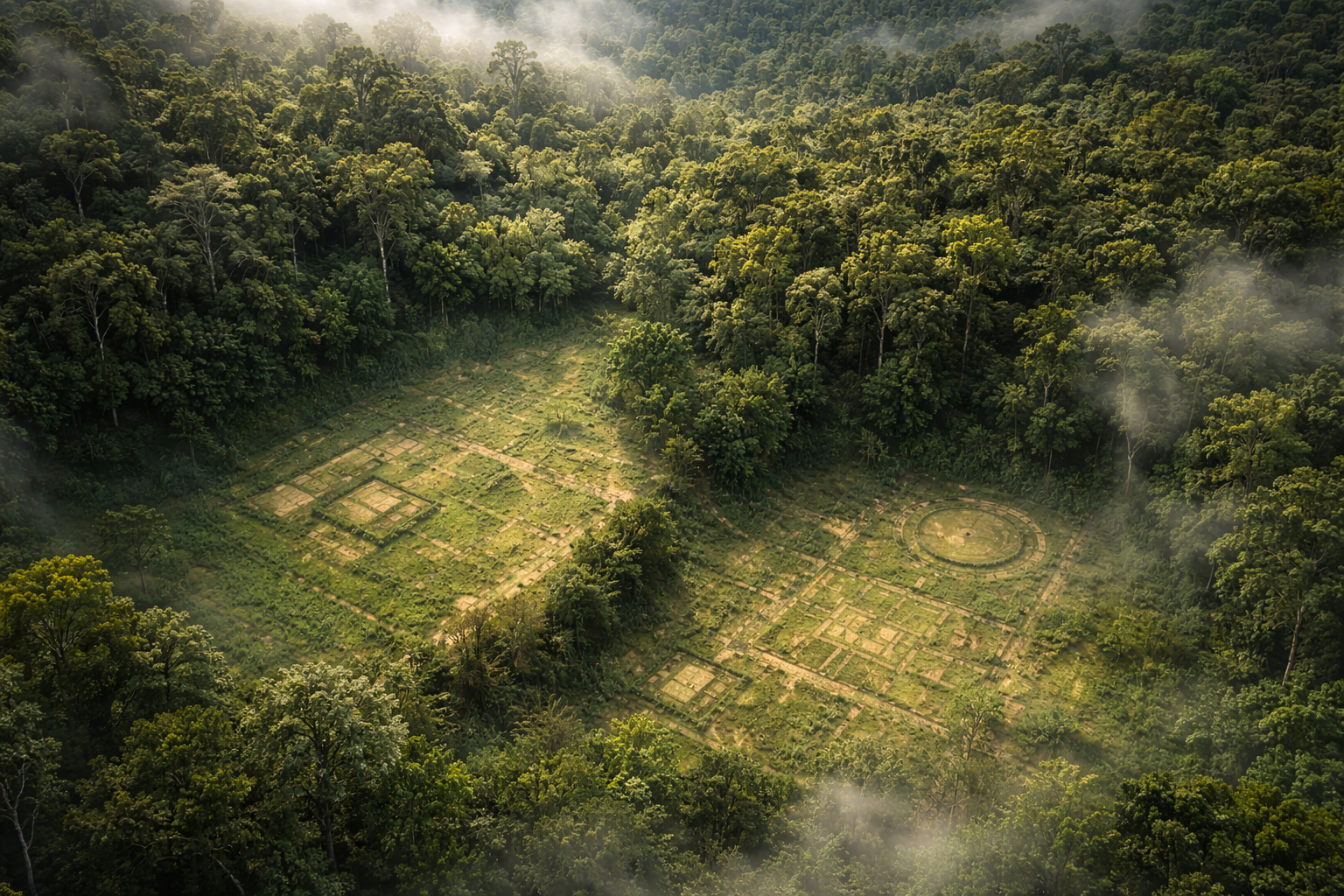
Study with LiDAR reveals up to 23 thousand hidden structures under the Amazon and points to pre-Columbian occupation much more extensive than previously imagined.
In 2023, a study published in the journal Science, involving 230 researchers from 156 institutions in 24 countries and led by scientists affiliated with INPE, provided one of the most robust pieces of evidence ever recorded about human occupation in the pre-Columbian Amazon. Using remote sensing technology based on lasers, known as LiDAR (Light Detection and Ranging), scientists were able to “see” hidden structures beneath the dense forest cover. According to the study “More than 10,000 pre-Columbian earthworks are still hidden throughout Amazonia”, published in Science, the combination of aerial surveys, archaeology, and statistical modeling allowed for the identification of new large-scale human traces beneath the Amazonian canopy.
The work analyzed 5,315 km² of LiDAR data distributed across the Amazon basin and revealed 24 previously unrecorded archaeological structures, including fortified villages, defensive and ceremonial structures, settlements in elevated areas, and other types of geoglyphs. Based on this data, researchers applied a predictive model of spatial distribution and estimated that between 10,272 and 23,648 large pre-Columbian structures may still be hidden in unmapped areas of the forest, with a higher likelihood of occurrence in the southwestern Amazon.
This discovery significantly alters the understanding of the region’s past, suggesting that the Amazon was not an isolated or sparsely populated territory, but rather an area with extensive, organized human presence capable of modifying the landscape on a large scale. The authors also identified an association between the likelihood of these structures’ occurrence and the presence of domesticated tree species, reinforcing the idea that pre-Columbian indigenous societies exerted a lasting influence on Amazonian ecology.
-
Why is chocolate so “addictive”? Studies show how chemical compounds activate the brain, trigger intense pleasure, and make it difficult to control consumption.

-
One Beetle for every 10 residents and streets taken over by the bug: the small town in the interior of São Paulo that became the National Capital of the Beetle and preserves a Brazil that seems to have stopped in time.

-
Goodbye dish rack: a new model of dish rack is gaining popularity in Brazilian kitchens for being more hygienic, compact, easy to store, and also reducing mold on countertops.

-
The secret superhero of Steve Jobs that took five years to come to life was blocked before its premiere due to an unexpected debt of millions — and the reason behind the blockage in Amsterdam still surprises today.

LiDAR technology allows mapping of invisible structures beneath the Amazon forest canopy
The basis of this discovery lies in the use of LiDAR, a technology that emits laser pulses from aircraft and measures the time it takes for these beams to return after hitting the ground. Even with the presence of dense vegetation, some of these pulses can penetrate the tree canopy and reach the ground, allowing for the reconstruction of three-dimensional models of the surface.

This process allows for the digital removal of vegetation and reveals the actual terrain, exposing:
- excavated ditches
- artificial elevations
- paths and geometric structures
Unlike traditional satellite images, which only capture the visible surface, LiDAR reveals what is hidden beneath the forest, making it an essential tool for archaeology in tropical regions.
Estimate of up to 23 thousand structures is based on statistical modeling, not direct count
One of the most impactful points of the study is the estimate that the Amazon may house between 10 thousand and 23 thousand archaeological structures. However, it is essential to understand that this number does not represent structures that have already been physically discovered.
The researchers identified a set of structures in the analyzed areas and, based on the observed density, applied mathematical models to project how many others may exist in still unexplored areas.
This approach is common in large-scale studies and allows for inferring regional patterns from samples. Still, the confirmation of each structure depends on new mapping and excavation campaigns.
Identified structures include geoglyphs, ditches, and areas modified by pre-Columbian peoples
Among the revealed structures are:
- geometric geoglyphs
- ditch systems
- areas of modified soil
- possible paths and connections between sites
These formations indicate direct human intervention in the environment, often with geometric patterns that cannot be explained by natural processes.
The geoglyphs, already known in Acre and other regions, are one of the most visible examples of this ancient engineering. However, LiDAR revealed that these structures may be just part of a much broader system of occupation and landscape modification.
Domesticated plants function as an indirect indicator of ancient human presence
Another important aspect of the study is the relationship between archaeological structures and the presence of domesticated plant species. The researchers identified that certain plants appear more frequently in areas where there is evidence of ancient human occupation.
Among these species are trees and plants historically used by indigenous peoples for food and forest management. These plants remain in the environment for generations, functioning as a kind of “biological marker” of past human presence.
This pattern suggests that the occupation of the Amazon involved not only the construction of structures but also a profound ecological knowledge and management of the environment.
Pre-Columbian Amazon may have been densely occupied and highly organized
The evidence gathered by the study reinforces a significant shift in how the Amazon is historically interpreted. For decades, the idea prevailed that the region was occupied by small, dispersed populations due to soil and environmental limitations.

However, the presence of thousands of structures and modified areas indicates that there were:
- organized communities
- interaction networks between groups
- land use systems adapted to the environment
This more recent view points to an intensely inhabited and transformed Amazon by its indigenous peoples.
Discoveries reinforce that a large part of the Amazon has not yet been archaeologically investigated
Even with technological advances, only a fraction of the Amazon has been analyzed using techniques such as LiDAR. This means that the number of known structures represents only a small part of what may exist.
Regions still covered by intact forest may hide:
- new geoglyphs
- ancient settlements
- path networks
- pre-Columbian agricultural areas
This perspective transforms the Amazon into one of the largest archaeological frontiers still little explored on the planet.
Difference between direct discovery and scientific estimate is fundamental for correct interpretation
One of the most important points for understanding the study is the distinction between structures identified directly and those estimated through modeling.
While the structures detected with LiDAR have concrete evidence, the total projected number depends on extrapolations based on observed patterns. This does not invalidate the estimate but requires caution in interpretation.
This distinction is essential to avoid misinterpretations or sensationalist readings about the scope of the discoveries. The dataset obtained using LiDAR has a direct impact on various fields of knowledge, including:
- archaeology
- historical ecology
- geography
- climate studies
By demonstrating that the Amazon was extensively modified by human populations in the past, the study contributes to a more complex understanding of the relationship between society and environment in the region.
Furthermore, these discoveries may influence current debates about conservation, land use, and sustainability.
Use of advanced technologies like LiDAR opens a new phase in tropical forest archaeology
The advancement of LiDAR represents a paradigm shift in archaeology, especially in hard-to-reach regions like the Amazon. The ability to map large areas without the need for deforestation allows for faster identification of archaeological sites and reduces environmental impacts.
This technology has already been used in other regions of the world, such as Central America, where it revealed hidden Mayan cities beneath the forest. In the Amazon, the potential is still far from being fully explored.
Recent discoveries indicate that the Amazon may hold a much larger volume of structures than previously imagined just a few years ago. The combination of advanced technology and new scientific approaches is just beginning to reveal the complexity of this region.
In light of this evidence, an inevitable question arises: how many other structures remain hidden beneath the forest, waiting to be revealed by new technologies?
Leave your analysis in the comments.


Seja o primeiro a reagir!