 Portuguese
  English
  Spanish
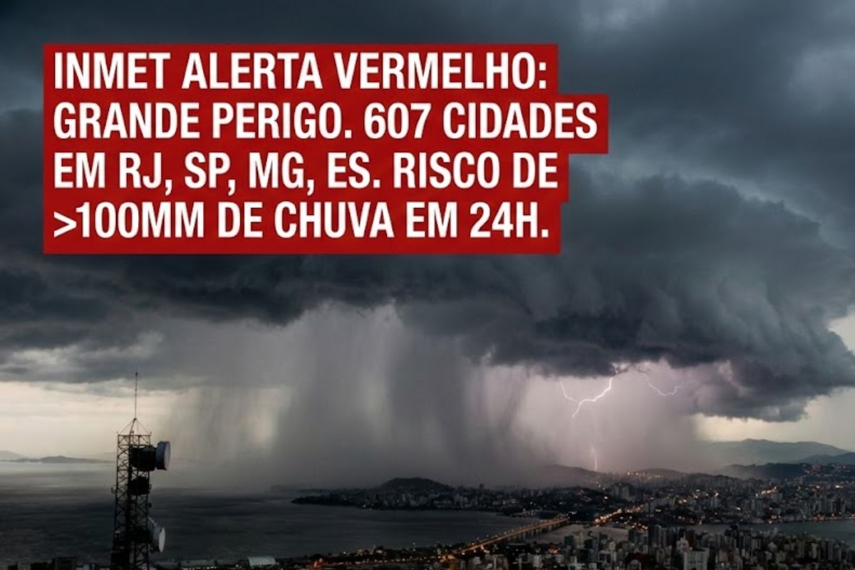
With 607 Cities in RJ, SP, MG, and ES Under “Great Danger”, Inmet Projects Accumulation Exceeding 100 mm in Less Than 24 Hours. The Scenario Increases the Risk of Flooding, Overflows, and Landslides. In Juiz de Fora, There Are Already 15 Dead, 19 Missing, and 440 Displaced in Just a Few Hours.
More than six hundred cities in Minas Gerais, Rio de Janeiro, São Paulo, and Espírito Santo have reached a maximum alert level with the red warning from Inmet this Tuesday, 24. The indication of “great danger” points to a critical combination: very heavy rain in a short time and a high probability of severe impacts.
The alert considers the possibility of accumulation above 100 millimeters in less than 24 hours, a scenario that pressures rivers, urban drainage systems, and slopes. In the most dramatic confirmed case, Juiz de Fora, in the Zona da Mata of Minas Gerais, has recorded 15 deaths, dozens of missing persons, and a public network on pause, with classes suspended and a state of emergency declared.
What the Red Alert from Inmet Really Indicates

The red alert is the most direct way to say that the atmosphere and the ground are moving towards a dangerous point at the same time.
-
Ten undergraduate students received an astronomy homework assignment, began sifting through data on the university’s computer, and ended up discovering the oldest star ever recorded in the universe, a cosmic immigrant that formed shortly after the Big Bang and was wandering alone towards the Milky Way.

-
Scientists reveal that Saturn’s rings may have formed after the destruction of a moon, and a study indicates that the planet’s bright structure is only 100 million years old.

-
A Brazilian who does not work at any space agency calculated a round trip route to Mars in just 7 months using asteroid trajectories as cosmic shortcuts, and the study was accepted by one of the most prestigious scientific journals in the world.

-
A continent of plastic that keeps growing: what no one tells you about the largest garbage dump in the world, which continues to grow endlessly.
When Inmet classifies the situation as “great danger,” the focus shifts from just the rain itself to what it provokes within the cities: large-scale flooding, overflows, and landslides.
The central component of this episode is the projected volume: above 100 mm in less than 24 hours. Practically speaking, this means water arriving faster than the drainage capacity of streets, streams, and channels in many cities, plus accelerated infiltration in already soaked lands, increasing instability in hillside areas.
Where Are the Cities Under Greater Risk in the Southeast
The highlighted critical area encompasses the entire territory of Espírito Santo and Rio de Janeiro, in addition to an extensive stretch between the coastal region of São Paulo and the Paraíba Valley and a large portion of the southern and western regions of Minas Gerais.
This is not a point alert, but a broad patch that crosses regions with very different characteristics, and for that reason, it requires local reading and a quick response within the cities.
Specifically, the regional breakdown indicates the following areas under danger. In Minas Gerais: Zona da Mata, Vale do Rio Doce, Campo das Vertentes, West of Minas, South/Southwest of Minas, Vale do Mucuri, and Greater BH.
In Rio de Janeiro: North, Northwest, Central and South Fluminense, Greater Rio, and Baixada Fluminense. In São Paulo: North and South Coastal Paulista, Baixada Santista, and Paraíba Valley.
In Espírito Santo: North Coast, North, Northwest, Central, and South Espírito-Santense. Each set of cities within these ranges may feel the effects in distinct ways, but the logic of risk is the same: concentrated heavy rain and little margin for error.
Why “More Than 100 mm in 24 Hours” Becomes an Immediate Threat
When rain arrives with this intensity, the issue is not just “getting soaked”: it’s the speed at which water accumulates and the ease with which it finds paths to flood.
In cities with rugged terrain, water rushes down, concentrates in low areas, and can turn streets into torrents.
In areas with rivers and streams already full, overflow goes from being a distant possibility to an imminent threat.
In the soil, the risk increases when infiltration cannot handle the volume. Saturated land loses cohesion, and in hillside areas, this opens space for landslides.
Therefore, an alert like this speaks not only about meteorology: it connects rain, terrain, drainage, and urban occupation—elements that together determine how much the cities can withstand without collapsing in vulnerable points.
Juiz de Fora and Zona da Mata: The Human Cost at the Center of the Alert
In Juiz de Fora, the sequence of storms since the weekend has already produced effects that go beyond routine and enter the sphere of emergency.
The city hall declared a state of public calamity early on Tuesday, 24, and suspended classes in the municipal network indefinitely.
When a city halts essential services, it usually indicates that the risk has moved from prediction to reality on the ground.
The human toll is the hardest figure: 15 confirmed deaths in Juiz de Fora on Tuesday morning, 24, with at least 19 people missing under the rubble and 440 forced to leave their homes since the previous night.
In the neighboring city of Ubá, authorities confirmed six deaths. In this context, Zona da Mata in Minas Gerais has recorded 21 deaths due to the rains, showing how the impact concentrates and spreads among nearby cities, with rescue and assistance networks strained simultaneously.
How Cities Can Reduce Risk in Floods and Landslides
In a “great danger” scenario, the priority is to reduce exposure to what causes the most fatalities: moving water and unstable ground.
For many cities, this starts with simple and quick decisions: avoiding movements in historically flood-prone areas, increasing caution near rivers and streams, and not underestimating signs of instability in slopes and hills.
The capacity for community response also plays a role: local alerts, alternative routes, support points, and clear communication help prevent panic from replacing organized action.
In times like this, what saves lives is the combination of monitoring, prevention, and speed because, with rain exceeding 100 mm in less than 24 hours, the window between “attention” and “occurrence” can be short within the most exposed cities.
The red alert from Inmet places 607 cities under the same roof of risk but the effects materialize unevenly, with the Zona da Mata in Minas Gerais already facing deaths, disappearances, and forced displacements.
When the forecast speaks of great danger, the reality often comes at a high cost precisely where the terrain, drainage, and urban occupation leave less room for escape.
Are you in one of the cities under alert or do you have relatives in these regions?
In your area, what concerns you most when the rain intensifies: flooding, rising river, unstable slopes, or lack of quick warning, and what usually works to prevent it?


-

Uma pessoa reagiu a isso.