 Portuguese
  English
  Spanish
Mapped In The Legendary Madaba Mosaic, The Lost Ancient City Of Tharais Has Been Finally Identified After Excavations Between 2021 And 2024 In El-’Iraq, On The Shores Of The Dead Sea, Revealing Christian Temples, Greek Inscriptions, And Signs Of A Self-Sufficient Economy
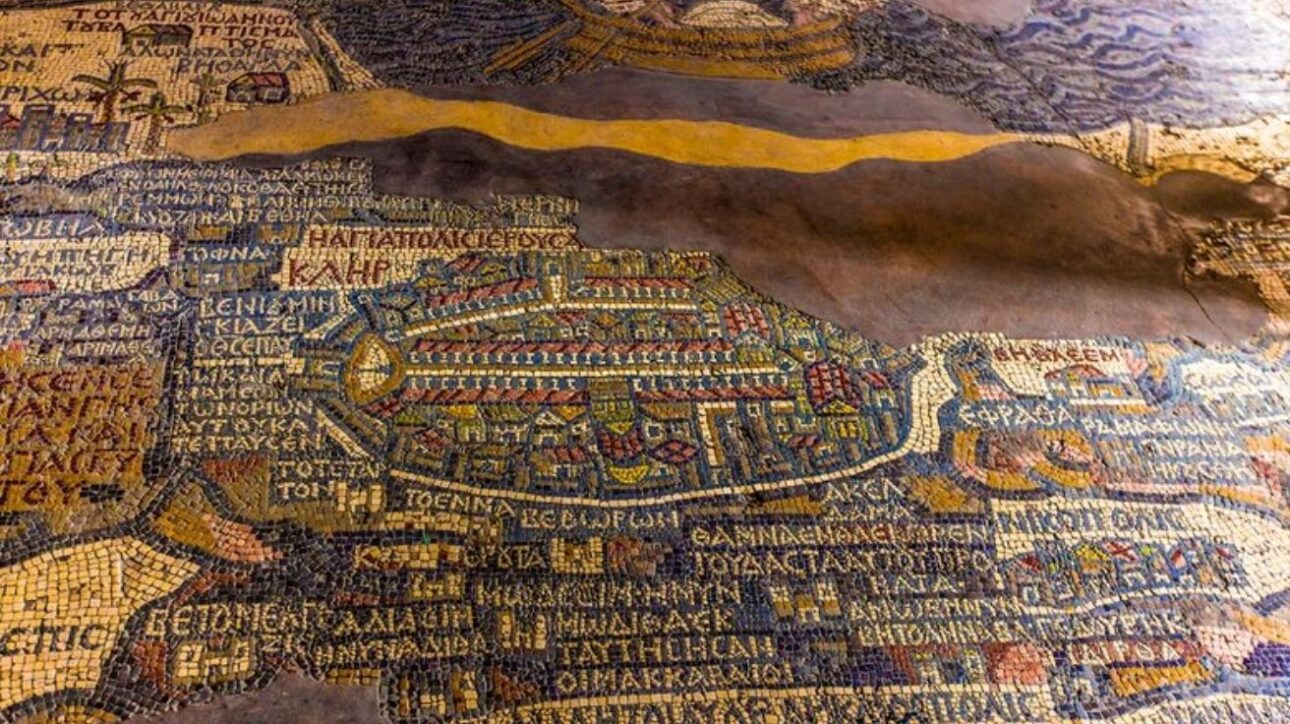
After More Than 1,500 Years Disappeared, The Lost Byzantine City Of Tharais May Have Finally Been Found. Located Near The Modern El-’Iraq, In Southeastern Jordan, The Discovery Was Made By A Team Of Archaeologists Led By Professor Musallam R. al-Rawahneh From Mutah University. The Find Was Only Possible Thanks To The Use Of The Ancient Madaba Map, A Mosaic Dating Back To The 6th Century A.D., Considered The Oldest Cartographic Map Of The Holy Land.
According To Popular Mechanics, The Excavation Project Lasted Three Years, Between 2021 And 2024, And Involved Collaboration With Institutions From France And Spain. At The Site, Researchers Found Mosaic Floors, Agricultural Tools, Remains Of Byzantine Churches, And Christian Funerary Inscriptions That Confirm The Religious And Commercial Identity Of The City. The Rediscovery Of Tharais Sheds Light On A Lost Chapter Of Byzantine Empire History And The Christian Presence In The Middle East.
The Rediscovery Of Tharais: Ruins, Religion, And Economy In The Heart Of The Holy Land
The Search For Tharais Began With An Audacious Goal: To Transform An Ancient Mosaic Map Into A Real Archaeological Guide. The Madaba Map, Located In An Orthodox Church In Madaba, Jordan, Was Created Around The Year 560 A.D. During The Reign Of Emperor Justinian. It Represents 157 Locations In The Holy Land With Impressive Visual And Historical Precision, Many Of Which Had Not Yet Been Found.
-
INMET danger alert: heavy rains between the 3rd and 4th may drop up to 100 mm/day and winds of 60 to 100 km/h in several regions of Brazil require extra caution.

-
The parts crisis may bring back the drop notch and microSD in 2026; while Windows 11 promises to become lighter, leaks mention batteries of up to 10,000 mAh and 200 MP cameras.

-
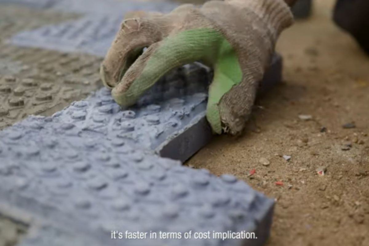
In Kenya, engineer Nzambi Matee created “bricks 2.0” using packaging plastic: a mixture with sand, heated and pressed; they are 5 times more resistant, already have official licensing, and are being used in streets and construction projects.
-
More than 20,000 positions could be opened, and thousands of technicians are starting to be trained in Brazil, as the expansion of data centers creates an urgent race for professionals to keep the internet, cloud, and artificial intelligence running 24 hours a day.


The Team Led By Al-Rawahneh Focused Their Efforts On The El-’Iraq Region, Near The Southeastern Tip Of The Dead Sea, Where Topographical Clues And Map Patterns Suggested The Presence Of Tharais. In The Field, Archaeologists Found Compelling Evidence: Mosaic Floors With Religious Patterns, Remains Of Glass, Agricultural Tools, And Inscriptions In Greek And Latin.
The Highlight Of The Excavations Was A Structure Similar To A Byzantine Basilica, With An Oblong Plan And An Open Central Space, Typical Features Of Churches From The Period. Architectural Portals Consistent With The Christian Temples Of The Era Were Also Identified, Reinforcing The Sacred Identity Of The City.
These Discoveries Show That Tharais Was Not Just An Agricultural Village, But Rather A Religious And Commercial Center, Serving As A Stopping Point For Pilgrims And Merchants Traveling Along The Routes Of The Holy Land. The Presence Of Well-Organized Christian Communities Is Also Made Clear By Funerary Inscriptions, Which Indicate Rituals And Liturgical Practices Of The Time.
However, The Lost City Of Tharais Also Thrived Economically. Olive Presses, Grain Milling Equipment, And Structures For Wine Production Were Found, Clear Signs Of Agricultural Self-Sufficiency And Large-Scale Local Production. This Disproves The Notion That Religious Sites Of Antiquity Were Economically Marginalized And Reinforces The Multifunctional Role Of These Cities.
The Resemblance Of The Ruins’ Layout To The Madaba Map Was Another Decisive Factor. Gates, Walls, And Possible Towers Follow Exactly The Configuration Recorded In The Mosaic. This Direct Correlation Was Key To Confirming The Identity Of The Lost City.
Overall, The Findings Reinforce The Importance Of The Intersection Between Field Archaeology And Historical Cartography. The Team Emphasizes That The Combined Use Of Ancient Maps And Modern Sensing Was Essential For Guiding The Excavations Precisely And Productively.
Now, The Researchers’ Greatest Challenge Is To Protect The Site From Rapid Urban Expansion In El-’Iraq. Professor Al-Rawahneh Stated That The Project’s Goal Goes Beyond Discovery: “We Want To Ensure The Preservation Of Jordan’s Rich Cultural Heritage For Future Generations.”
The Rediscovery Of Tharais Rekindles The Debate About How Much More There Is To Discover In The Middle East. With The Support Of Modern Technologies And The Reinterpretation Of Ancient Historical Documents, Other Lost Cities May Be About To Emerge From The Sands Of Time.


-

2 pessoas reagiram a isso.