Portuguese
  Spanish
INMET warning predicts high volumes in a short period and gusts of 60 to 100 km/h, with risk of floods, tree falls, and service interruptions
The INMET issued a warning for heavy rains classified as danger, valid from Thursday (2) until 11:59 PM on Saturday (4). The warning draws attention due to its scope, the high volume of precipitation in a short time, and the presence of strong winds, which requires increased attention and constant monitoring of official information.
In addition to the rain, INMET highlights that the combination with winds of 60 to 100 km/h increases the risk of damage to urban and rural infrastructure. This includes falling trees and branches, damage to the electrical grid, and interruptions of essential services, especially in areas more vulnerable to flash floods and stream overflows.
What characterizes the INMET heavy rain warning
INMET considers “heavy rains” to be events where it rains heavily in a short period, with forecasts of 30 to 60 millimeters per hour or 50 to 100 millimeters per day.
-
World Cup Ball Chip Uses Technology to Detect Invisible Touches, Confirms Offside, Secures Portugal’s Victory Over Croatia

-
36-Meter Hydrogen-Powered Superyacht Arrives in Brazil to Debut German Engines and Showcase Future of Clean Navigation

-
Indian Students from Jaipur Win Top Prize at World’s Largest Science Fair with EcoFog, an Affordable Mesh to Harvest Fog Water Without Energy

-
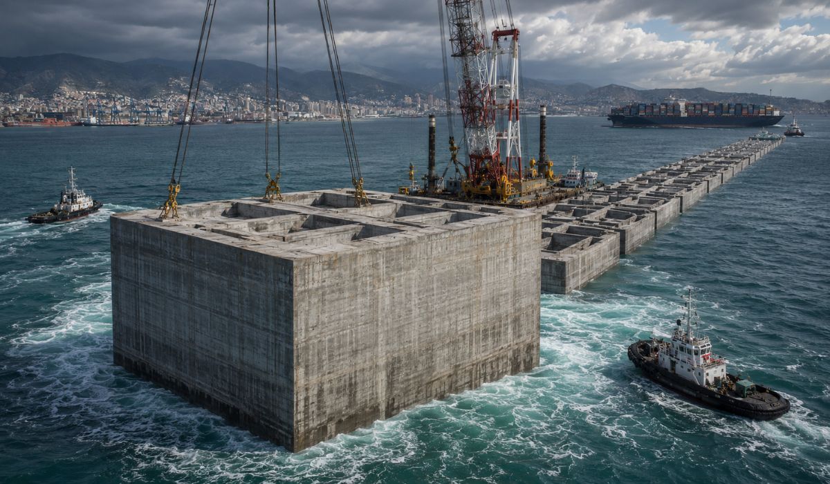
Italy Sinks Massive 11-Story Concrete Structures in the Ligurian Sea to Create a 6.2 km Barrier, Clearing the Way for 400-Meter Ships in Genoa


This volume puts pressure on the drainage system and increases the chance of flooding and flash floods, especially in urban areas with more fragile infrastructure.
Why the warning is classified as danger
The classification of danger arises because the scenario combines a large volume of rain with strong winds. This combination usually increases the potential for material damage and risk to the population, as gusts can knock down trees, hit roofs and metal structures, and cause failures in the electrical grid.
With the soil saturated, the probability of landslides and collapses on unstable slopes also increases, affecting both urban and rural areas.
Main risks and expected impacts
The INMET alert highlights flooding on roads and riverside areas, temporary power outages, falling branches and structures, and an increased risk of electrical discharges.
The problem is not just the rain itself, but the cascading effect: accumulated water, strong winds, lightning, and saturated soil can lead to sequential disruptions, especially in places with a history of floods or geological risk areas.
How to act during the INMET warning
During the validity of the INMET warning, the recommendation is to avoid sheltering under trees and not to park vehicles near transmission towers, poles, and large signs, which may fall with gusts. It is also advised to keep a distance from windows and avoid crossing flash floods on foot or by car.
In times of strong storms, turning off electrical appliances and, if possible, the main power panel helps reduce risk of short circuits and damage to equipment. In case of emergency, the guidance is to contact Civil Defense at 199 and the Fire Department at 193.
Regions under INMET warning
The INMET informs that the warning affects hundreds of municipalities in different states, involving regions of the Midwest, Southeast, North, Northeast, and part of the South. Among the mentioned meteorological areas are Central Goiás, Triângulo Mineiro and Alto Paranaíba, Northeast Pará, Northern Pioneer Paraná, Southern Ceará, Zona da Mata, Federal District, Metropolitan São Paulo, Metropolitan Rio de Janeiro, Lower Amazon, Acre Valley, Northern Roraima, Pernambuco Sertão, and São Francisco Valley of Bahia, showing the broad reach of the instability system.
Why monitoring makes a difference
In a large country, broad alerts like this reinforce the need to follow official bulletins and local guidelines, because the intensity and risk vary from one municipality to another.
Combining information from INMET with simple prevention actions can reduce damage and avoid dangerous situations, especially where there is a history of flooding, landslides, and falling trees.
In your city, when INMET issues a danger alert, do you change your routine immediately or only worry when the rain starts to get heavy?