 Portuguese
  English
  Spanish
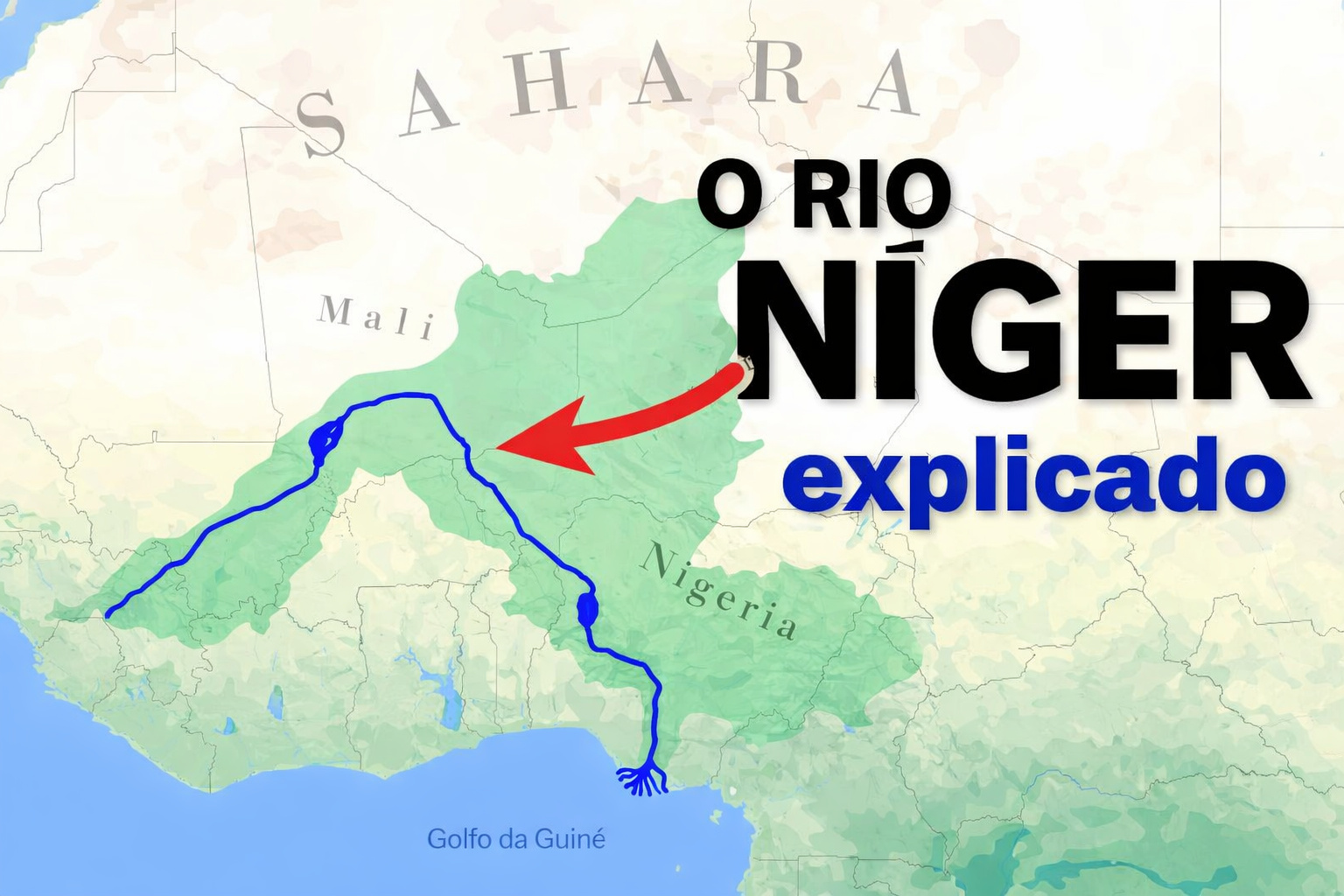
The Interior Delta of the Niger River Floods Up to 30,000 km² in Mali, Redistributes Sediments, and Supports Millions as Dams Begin to Alter This Ancient System.
According to hydrological studies conducted by African and European universities, as well as historical data from the Malian government and international agencies related to water resource management in the Sahel, the Interior Delta of the Niger River is one of the most unique river phenomena on the planet. Unlike classic deltas that form at river mouths, this delta emerges in the interior of the continent, when the Niger loses speed in an extensive low-lying plain and starts to spread laterally, creating a seasonal sea of water, sediments, and life.
During the flood season, the river ceases to be a defined channel and transforms into a diffuse system of lakes, temporary arms, and flooded areas covering an area comparable to that of whole countries. This natural dynamic has sustained millions of people for centuries and acts as one of the largest ecological regulators of West Africa.
A Delta That Does Not Reach the Sea, but Dominates the Territory

The Interior Delta of the Niger is mainly located between the cities of Ségou, Mopti, and Timbuktu, in Mali.
-
Goodbye iron: new technology from Xiaomi promises to revolutionize the way we iron clothes with 500 kPa steam, continuous flow of 120 g/min, heating in 65 seconds, and six smart modes for different fabrics.

-
Rio Pardo, the most mysterious city in Rio Grande do Sul: untouched Pampas castle, the missing treasure of the Devil Boy, bride’s saint, invisible tunnels, and a 200-year curse today.
-
China retires the J-7 fighter after years of military protection and can now transform military items into drones, following more than 60 years of operation of the J-7, derived from the MiG-21, with thousands of units produced and strategic use in the PLAAF and PLANAF.

-
Volunteers are sought to live in the mountains for a month: a study pays people to stay at 2,500 meters, with 24-hour monitoring of sleep, metabolism, and blood pressure.


Instead of advancing toward the ocean, the river enters an extremely flat region, where the terrain’s slope drops drastically. The result is that the water slows down, spreads out, and floods between 20,000 and 30,000 km² each rainy season.
In exceptionally wet years, hydrological records indicate that the flooded area can approach 40,000 km², but the figure of 30,000 km² is the most widely accepted as a technical reference. This flooding is not a one-time event: it repeats every year, with a predictable rhythm, shaping the economy and ecology of the region.
Millions of Tons of Sediments Redistributed Each Flood
The waters reaching the interior delta carry sediments from thousands of kilometers of watershed, including areas of Guinea, where the Niger originates. When the river spreads across the delta, its speed drops abruptly, causing a large portion of these sediments to be deposited in the floodplain.
This natural process:
- fertilizes the soil without the need for chemical inputs,
- sustains wet-season agriculture,
- maintains fishery productivity,
- and stabilizes the terrain over centuries.
Each annual cycle, millions of tons of sediments are redistributed, renewing the soil and ensuring the resilience of the system in a semi-arid environment.
A System That Acts as a Climate Regulator in the Sahel

In addition to its agricultural and ecological roles, the Interior Delta of the Niger acts as a regional climate buffer. By spreading water over thousands of square kilometers, the system:
- reduces flood peaks downstream,
- extends water availability during the dry season,
- and creates more humid microclimates within the Sahel.
Without this natural mechanism, large areas of Mali would be significantly drier and more vulnerable to desertification.
Dams and Hydraulic Control Upstream
In recent decades, the ancient balance of the delta has been influenced by hydraulic infrastructures built upstream, especially dams intended for power generation and irrigation.
The most important of these in the context of Mali is the Markala Dam, which regulates flows for one of the largest irrigation systems in West Africa.
Additionally, projects in upstream countries of the basin, such as Guinea and Nigeria, have begun to alter the timing and volume of floods, directly interfering with the dynamics of the interior delta. Even small changes in flow regime can result in:
- reduction of the flooded area,
- less sediment deposition,
- direct impacts on fishing and wet-season agriculture.
When Engineering Meets a Highly Sensitive System
From a technical standpoint, the Interior Delta of the Niger is an extremely sensitive system to artificial regulation. Unlike rivers confined in narrow valleys, where dams control volumes predictably, here the functioning depends on broad and slow floods.

Any attempt to “over-regulate” the flow may compromise the seasonal flooding that supports:
- over a million people directly,
- one of the largest wetlands in Africa,
- traditional routes for fishing, grazing, and cultivation.
Therefore, the delta is often cited in studies as an example of the practical limits of hydraulic engineering, where over-control means destabilizing the system.
An Interior Delta That Has Existed for Centuries but Depends on Modern Decisions
The Interior Delta of the Niger is not a recent creation nor a geographic accident. It has existed for thousands of years and has survived drier and wetter climatic periods. What has changed is the scale of human intervention.
Today, decisions made hundreds of kilometers upstream — opening or closing sluice gates, retaining water for irrigation or energy — have a direct impact on a floodplain the size of a country.
It is a clear example of how modern engineering and colossal natural processes have started to operate within the same system, not always in balance.
One of the Largest Active River Systems on the Planet
In the end, the Interior Delta of the Niger remains one of the largest and most active river systems in the world, not because of concrete or machinery, but due to the annual repetition of a gigantic natural process: water slowing down, sediments depositing, and territory being recreated season after season.
It is a landscape that only exists because the river can still escape, in part, the total control of engineering — and which shows how, in certain places, the scale of nature continues to compete equally with the greatest human endeavors.


-

-

2 pessoas reagiram a isso.