 Portuguese
  English
  Spanish
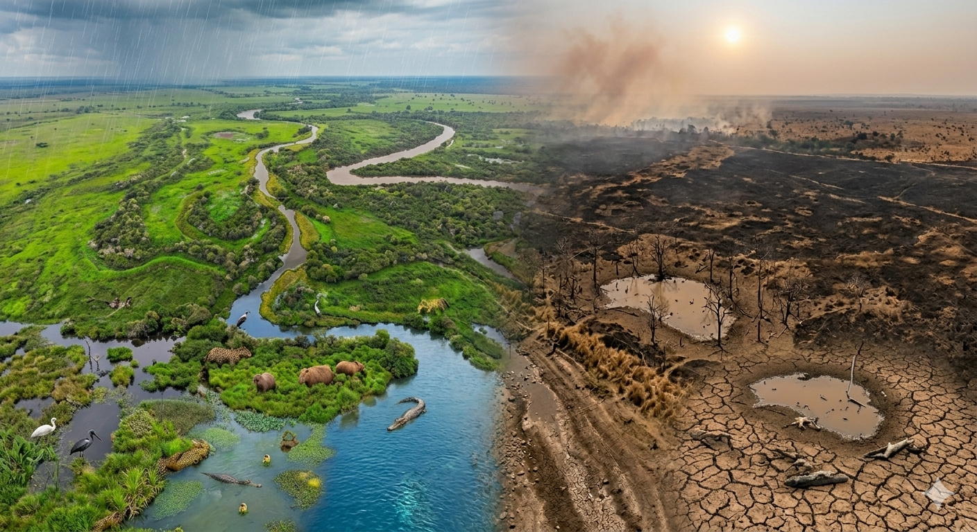
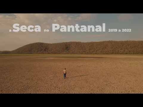
Historical drought in the Pantanal between 2019 and 2020 reduced 34% of the flooded area, dropped rivers to minimum levels, and caused fires in 30% of the biome.
There is a place in Brazil where the ground disappears under water every year. For months, entire plains are submerged, rivers overflow onto the flat land, ponds appear where there was once pasture, and roads disappear under the advance of floods. This is the natural functioning of the Pantanal, the largest floodplain on the planet, covering about 150,000 km² distributed between Mato Grosso and Mato Grosso do Sul. It is a biome that directly depends on water. Its ecological balance is tied to seasonal floods, which sustain the entire local food chain.
In 2019, this cycle began to fail. The rains were below expectations, the rivers did not rise as they had in previous decades, and when NASA satellites and analyses involving researchers from INPE began to record the behavior of the biome throughout 2019 and 2020, what appeared was a continuous process of drying out. According to images published by the NASA Earth Observatory and the study “Extreme Drought in the Brazilian Pantanal in 2019–2020: Characterization, Causes, and Impacts”, involving a researcher from CPTEC/INPE, the rainy season of 2020 failed to adequately recharge the wet areas, and the Pantanal entered the worst drought recorded in 50 years, with the wet season showing between 50% and 60% less rain than normal in parts of the analyzed period.
The result was the progressive transformation of the largest swamp on the planet into an increasingly dry landscape, month after month.
-
An abandoned villa for over 80 years with underground mines, a 130-meter zip line, historical ruins, and challenging trails makes Cwmorthin, in Wales, an unusual destination.
-
This wind turbine fits in a water bottle, weighs only 1.4 kilograms, charges cell phones and laptops with any breeze above 13 kilometers per hour, and works day or night, in rain or shine.
-
It is 95% water, controls blood sugar, strengthens bones, and almost no one eats it: maxixe is the most forgotten vegetable in Brazil and one of the most powerful you could put on your plate today.

-
Man surprises by building a boat made of ice capable of floating on water.

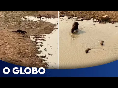
Satellite images show drastic reduction of water and rivers in the Pantanal at the lowest level since 1971
The satellite images recorded between 2019 and 2020 show a transformation that completely deviates from the expected pattern for the region.
Areas that should be flooded showed dry and cracked soil. Seasonal ponds disappeared, and the rivers remained confined to their beds, unable to flood the plain.
Data from INPE indicate that the flooded surface of the Pantanal in 2020 was 34% smaller compared to the historical average between 1982 and 2020. Precipitation was 26% below normal, and April 2020 was the driest month in over 120 years of records.
The Paraguay River, the main waterway of the biome, reached critical levels. At the Ladário (MS) station, records reached negative levels, indicating levels below the historical reference. In Barra do Bugres (MT), the level dropped to just 24 cm, the lowest since 1966.
Researchers from Cemaden and Unesp classified the event as the most severe drought in the last 50 years.
Causes of the drought in the Pantanal involve Atlantic warming, atmospheric blockage, and environmental degradation
The large-scale drought recorded in the Pantanal does not have a single cause, but rather a combination of climatic and environmental factors.
The first identified factor was the warming of the tropical Atlantic, which interfered with the moisture transport known as “flying rivers”, responsible for carrying water vapor from the Amazon to the central-southern part of the continent.
The second factor was the occurrence of atmospheric blockages, high-pressure systems that prevented the formation of rain for prolonged periods. As a result, evaporation exceeded water replenishment.
The third factor involves environmental degradation in the regions that feed the Pantanal, especially in the Cerrado and the Amazon. Deforestation contributes to the silting of rivers and reduces the capacity to retain and transport water to the floodplain.
Fires in the Pantanal in 2020 affected 30% of the biome after months of extreme drought
The absence of water created ideal conditions for the spread of fires. In 2020, the Pantanal recorded the highest number of fires since satellite monitoring began in 1998. INPE recorded 22,116 fire hotspots, exceeding the previous record by 76%.
The fire affected 44,998 km², equivalent to approximately 30% of the entire biome.
High-resolution satellite images showed fire fronts advancing for hundreds of kilometers, reaching areas that had never burned before. About 35% of the affected areas were considered intact until then.
The functioning of the Pantanal depends on the cycle of floods and droughts that has been interrupted in recent years
The Pantanal functions as a cyclical system, alternating between periods of flooding and drought throughout the year. During the rainy season, from November to April, the rivers overflow and flood vast areas. This process is essential for the reproduction of species and the maintenance of biodiversity.
Between May and October, the water recedes, exposing the soil and allowing for other ecological dynamics. When this cycle is interrupted, the entire system becomes unbalanced, compromising fundamental ecological processes. The drought of 2020 was not an isolated event.
Since 2019, the Pantanal has faced consecutive periods of severe drought. In 2024, the Geological Service of Brazil recorded the worst drought in the history of the biome, with the Paraguay River reaching -67 cm at the Ladário station.
Data from MapBiomas indicate an 81.7% reduction in the water surface of the Pantanal between 1985 and 2022. Cemaden also confirmed that the region is facing the worst drought since 1950, with an accumulated water deficit exceeding 1,000 mm between 2020 and 2024.
Satellite monitoring allows real-time tracking of the degradation of the Pantanal
Satellite observation technology has transformed the way to monitor the biome. INPE produces hundreds of daily images of Brazilian territory, allowing for precise tracking of fires, river levels, and vegetation cover.
Today, it is possible to observe in almost real-time the evolution of the drought, the expansion of fires, and the reduction of water in the Pantanal. However, experts point out that the availability of data does not guarantee effective mitigation actions.
Now we want to know: what can be done to prevent the collapse of the Pantanal?
The drought of 2020 demonstrated that the balance of the Pantanal depends on climatic and environmental factors that go beyond the biome itself.
With available data and constant monitoring, the central issue shifts from being technical to being decision-making. In your view, what measures could prevent the Pantanal from continuing to lose water and biodiversity in the coming years?


Seja o primeiro a reagir!