 Português
  Inglês
  Espanhol
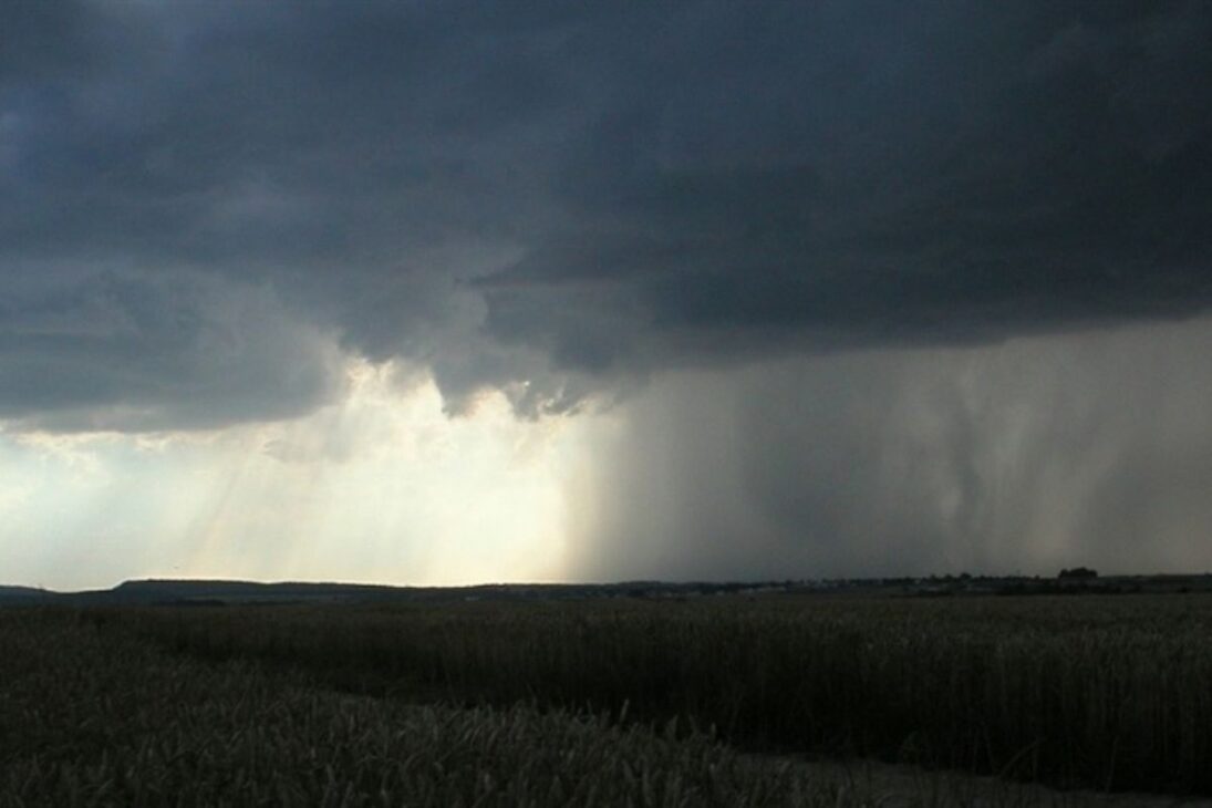
Giant Rivers Floating Above Our Heads, Bulkier Than the Amazon in Intense Events, Transport an Invisible Colossus of Vapor That Irrigates Key Regions, Feeds Reservoirs and, When Stationary, Multiplies the Risk of Disasters
The giant rivers that traverse the atmosphere act as concentrated corridors of water vapor, long and narrow, responsible for transporting a colossal volume of moisture from the tropics to higher latitudes. Invisible to the naked eye and detected by satellites, these flows explain everything from the regularity of beneficial rains for agriculture to episodes of extreme precipitation that challenge urban and rural infrastructure.
In South America, the interaction between the Atlantic Ocean, Amazônia Forest, and Andes Mountains creates a unique hydrological mechanism. When a moisture corridor is amplified over the forest and diverted south and southeast by the Andes, it supplies reservoirs, supports the hydroelectric matrix and, in certain configurations, intensifies rain systems that can have severe impacts.
What Are Atmospheric Rivers and Why Do They Matter
Atmospheric rivers are filaments of concentrated moisture that traverse the lower and middle troposphere, with some kilometers of thickness and hundreds of kilometers in width.
-
With an unusual prize, Japan transforms office chairs into a resistance race on the streets, ISU-1 Grand Prix grows, fills stages, and pays 90 kilograms of rice.

-
House in England with a 7.6-meter shark embedded in the roof attracts attention worldwide and becomes a curious attraction in Oxford.

-
Masterpiece in Spain, under construction since 1882, receives 4.8 million visits in a year and impresses with its gigantism and architecture.

-
Attracting around 250,000 people a year, a lighthouse 200 meters from the sea, on a 60-meter high cliff, on the North Sea coast in Denmark, becomes one of the most impressive examples of how nature can threaten historical buildings.


Even occupying a small fraction of the sky at any moment, they account for a large portion of the meridional transport of water vapor, connecting tropical ocean sources to distant continental regions.
The analogy with rivers helps to communicate scale and direction, even though the “flow” is dispersed vapor, not liquid water channelized.
Interest in these corridors has grown because they are structural pieces of the hydrological cycle.
In years when they arrive with regularity and moderate intensity, they ensure aquifer recharge, natural irrigation, and stability of energy production.
In years of atmospheric blockages, trajectory deviations, or stationarity, the absence or excess of moisture can trigger severe droughts or destructive floods.
The South American Mechanism: Ocean, Amazon, and Andes
The journey begins over the tropical Atlantic, where strong evaporation loads the lower layers of the atmosphere with vapor.
The trade winds push this moist mass westward, toward the continent.
Upon entering the Amazon, the flow is turbocharged by evapotranspiration: trees release enormous amounts of water into the atmosphere, recycling and amplifying the initial moisture.
Next, the Andes Mountains act as a divider.
Part of the moisture precipitates as it climbs the slopes, but most of the corridor is diverted south, channeling the flow to the Midwest, Southeast, and South of Brazil, as well as to Paraguay, Uruguay, and northern Argentina.
Without the Andes, much of this moisture would follow to the Pacific, profoundly altering the distribution of rainfall on the continent.
How Much They Transport and How We Compare
In strong events, the giant rivers can transport water mass per unit of time greater than the average flow of the Amazon, reaching multiples of that value when the corridor is extensive and well-organized.
The comparison is valid as an order of magnitude of the transport of H₂O, but requires nuance: in the terrestrial river the flow is liquid and channeled, in the atmospheric corridor it is vapor distributed in air volume.
Still, the message is unequivocal: we are facing an invisible colossus.
Measuring the unseen requires technology.
Microwave satellites and Total Precipitable Water products allow for mapping of high-moisture plumes, while numerical modeling reconstructs wind, convergence, instability, and trajectory.
High and persistent integrated moisture values aligned with strong winds are a classic signature of an active corridor with potential for heavy rainfall.
Lifeline and Risk: Impacts in South America
On a continental scale, these flows sustain agriculture, recharge reservoirs, and supply metropolises, especially when they advance in a mobile and distributed manner.
When they encounter favorable topography or low-pressure systems, they can concentrate precipitation for many hours over the same basin, rapidly elevating river levels and saturating slopes.
Recent events illustrate the duality.
In Southern Brazil, episodes with persistent moisture corridors fueled exceptionally voluminous rain systems, with previously saturated soil and accelerated surface runoff.
In Santa Catarina, interactions between moist plumes and east winds channeled by the Serra do Mar demonstrated how regional phenomena can transform a beneficial corridor into a trigger for overflowing and landslides.
Changing Climate: Intensification and Displacement
The physics are straightforward: warmer atmospheres retain more vapor.
With warming, it is expected that atmospheric rivers will be longer, wider, and have a greater moisture load, which shifts the rainfall regime to more frequent and intense extremes.
The practical result is reduction of intermediate rains and increase in peak events, a challenging scenario for water and urban planning.
There are also signs of migration of average trajectories toward the poles.
Regions relying on these corridors may experience longer dry windows, while areas outside the historical reach may begin to suffer recurring intense rainfall episodes.
The infrastructure designed for a past climate needs to be reconsidered in light of this new pattern.
How to Predict and Mitigate: From Satellite to Model
Continuous monitoring by geostationary and polar orbit satellites provides images and moisture estimates almost in real-time, essential for identifying the formation and evolution of plumes.
At the same time, numerical prediction models assimilate observations and simulate scenarios of trajectory, intensity, and coupling with fronts, cyclones, and topography.
The challenge remains to convert meteorological forecasts into impact forecasts.
Susceptibility maps, dam management, high-capacity urban drainage, and alert protocols are the bridge between atmospheric diagnosis and damage reduction.
Land-use planning that avoids occupation of risk areas and solutions like sponge cities help to dampen runoff peaks.
The giant rivers are the backbone of water in South America and, at the same time, the engine of extremes when conditions align.
Understanding their genesis, route, and variability is a condition for security in water, energy, and urban contexts.
With robust monitoring, more accurate models, and land-use policies aligned with science, it is possible to transform a risk into a competitive advantage for climate adaptation.
In your city, what is the weakest link in the face of a stationary moisture corridor: urban drainage, slopes, rivers, or dam management? What concrete measure could your school, company, or city hall adopt in the next six months to reduce the impact of recurring floods? Share in the comments what practical experiences worked or failed in your region and what needs to change now.


-

-

-

-

8 pessoas reagiram a isso.