 Portuguese
  English
  Spanish
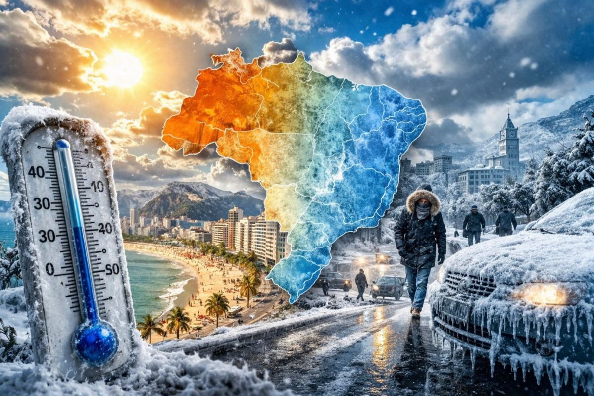
The cold air mass entering Brazil after the passage of the extratropical cyclone is expected to drop temperatures in the mountains of Santa Catarina and Rio Grande do Sul to 0°C and bring localized frosts to the Mantiqueira Mountains in the Southeast between Friday and Sunday, with impacts also in the Midwest.
The extratropical cyclone that brought storms to Brazil last week moved away towards the ocean on Wednesday (8), but left a trail that is not yet over. The cold front associated with the phenomenon continues to act with predictions of storms in the Southeast and Midwest in the coming days, and right behind it comes an intense cold air mass that is expected to drop minimum temperatures to 0°C in the southern mountains of Brazil. This is the first significant polar air intrusion of this autumn, and the effects will be felt from Santa Catarina to the Mantiqueira Mountains.
According to Meteored, the cold air mass also brings a risk of localized frosts for Brazil, in addition to significant cold across the Central-South region. The areas with the highest chance of recording minimums close to 0°C are the mountains of Santa Catarina and Rio Grande do Sul, but the reach of the system goes beyond: between Friday (10) and Sunday (12), Rio de Janeiro, Espírito Santo, and Minas Gerais will also be influenced by the cold air mass, with possible frosts around the Mantiqueira Mountains.
When the cold air mass arrives and what temperatures to expect
According to information from the portal ndmais, the timeline for arrival is clear. This Friday (10), minimum temperatures in the South region will already be below 20°C in a widespread manner.
-
The South American bird that seems to carry a natural “Sharingan” has intense red eyes that shine like glass in the water and makes the small diver one of the most unusual sights in the lakes of South America.

-
The real scientific weapon of NASA: satellites that monitor the climate, connect missions, and hunt for life, from Explorer 1 to James Webb, showing how they are designed, tested, launched, activated, and retired in Earth’s orbit.

-
Credit card on the inside: acetone reveals antenna, Soviets create energy-free listening devices, and fraud evolves from easily cloneable magnetic strips to encrypted chips and still vulnerable contactless payments today.

-
Scientists have recorded 12 sunken vessels on the seabed around the port of Santos: seven have already been studied, with highlights including the Casador from 1828, the Questrel that appears at low tide, and the Professor Besnard, which capsized after a recent heavy rain.

Mountain municipalities in Santa Catarina and Rio Grande do Sul may register temperatures between 6°C and 7°C at dawn, and forecasts indicate that in the following days, the intensity of the cold air mass may push thermometers down to 0°C in these same regions. The higher altitude areas will feel the impact first.
The cold intensifies over the weekend. Saturday and Sunday are expected to be the coldest days, with the cold air mass already consolidated over the South and advancing towards the Southeast and the Midwest.
For those in the mountainous plateau of Santa Catarina or Rio Grande do Sul, the recommendation is to prepare heavy clothing and protect sensitive plants and animals from extreme cold, as temperatures close to 0°C can cause damage to crops and put the health of vulnerable individuals at risk.
Which regions of the Southeast will be affected by the cold air mass
The cold air mass will not be restricted to the South. Between Friday and Sunday, the system will reach the Southeast with enough strength to cause localized frosts in the Mantiqueira Mountains, the high-altitude region that extends between São Paulo, Minas Gerais, and Rio de Janeiro.
Cities like Campos do Jordão, Monte Verde, and other mountainous locations above 1,500 meters in altitude are expected to record significantly lower temperatures than normal for this time of year.
Meteored indicates that Rio de Janeiro, Espírito Santo, and Minas Gerais will feel the effects of the cold air mass over the weekend, although with less intensity than the South. The minimums are not expected to reach 0°C in these capitals, but the drop in temperature will be noticeable, especially in the early mornings of Saturday and Sunday.
For most residents of the Southeast, the impact will be a colder weekend than usual, but for farmers and producers in the mountainous areas, frost can mean losses.
What happens in the Midwest during the passage of the cold air mass
The influence of the system will also be felt in the Midwest, although less intensely than in the South and Southeast. Mato Grosso do Sul is expected to register the largest drop in temperature in the region, with milder minimums than the standard for the season.
The extreme south of Mato Grosso and the southern and eastern portions of Goiás will also be affected by the cold air mass.
For the Midwest, the cold air mass does not pose a frost risk, but rather a noticeable change in thermal sensation.
The range between day and night tends to increase: days still reasonably warm contrasting with significantly colder nights. This is a typical pattern of polar air entry that loses strength as it moves to lower latitudes, but still carries the potential to surprise those who do not follow the forecast.
How to protect yourself during the passage of the cold air mass
The recommendations are straightforward and especially apply to residents of the mountains in the South and Southeast. Dressing appropriately is basic, but greater attention should be given to the elderly, children, and homeless individuals—the groups most vulnerable to hypothermia when temperatures approach 0°C.
Those with pets or livestock should provide heated shelters and check access to water (which can freeze in exposed troughs).
For agriculture, the cold air mass with frost risk requires preventive measures. Producers of vegetables, fruits, and coffee in the mountainous areas should monitor the forecast hour by hour and, if necessary, adopt protection techniques such as sprinkler irrigation or covering with straw.
Frost burns exposed leaves and shoots, and in sensitive crops, a single night of negative temperatures can compromise part of the harvest. The cold air mass passes in a few days, but the damage from a frost can last for months.
Are you in the risk area of this cold air mass? How are you preparing for the intense cold?


Seja o primeiro a reagir!