 Portuguese
  English
  Spanish
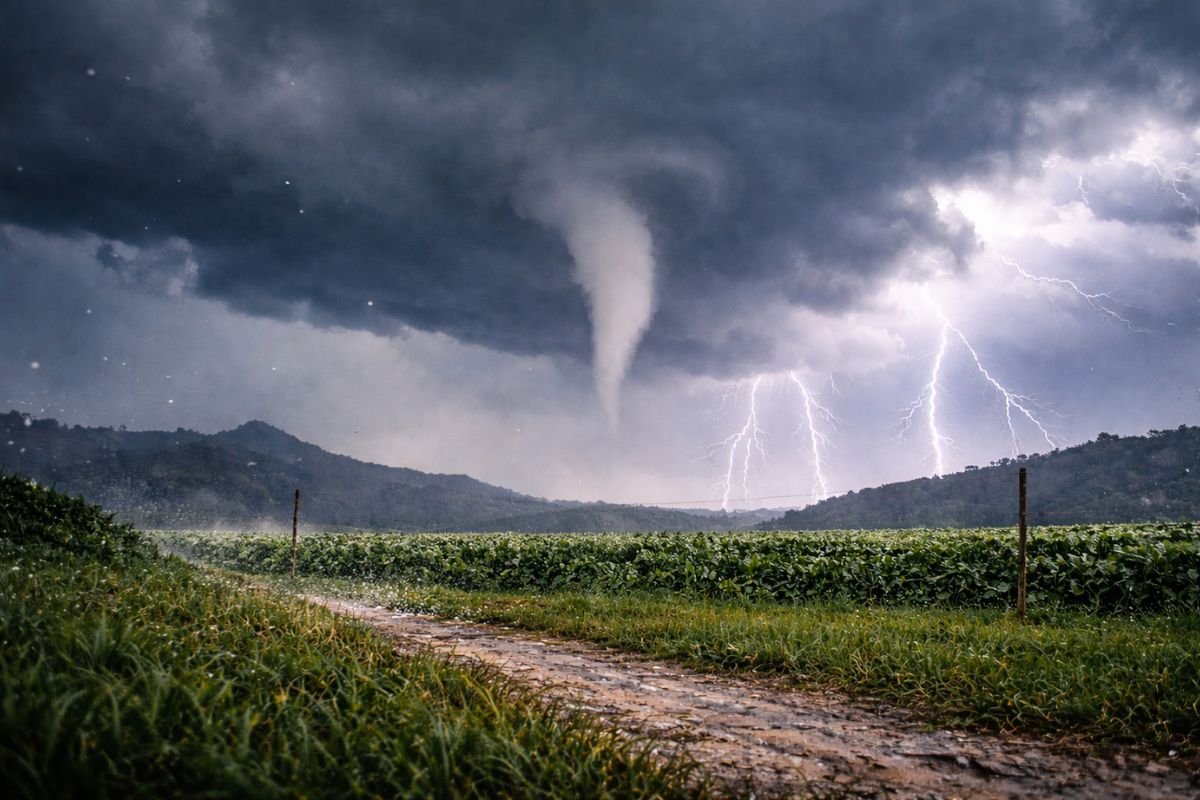
In Bom Retiro, A Funnel Cloud With Visible Rotation Surprised Residents And Raised Questions About A Tornado, But Did Not Touch The Ground. On The Same Saturday, Severe Storms Struck The Eastern Part Of Santa Catarina With Lightning, Severe Hail, And Intense Rain, Fueled By Heat, Humidity, And Low Pressure, According To Civil Defense In Isolated Areas.
The severe storms that moved through Santa Catarina on Saturday (31) gained a “character” that usually scares even those used to unstable summers: a funnel cloud spinning over Bom Retiro, in the Southern Plateau, looking like a tornado seen from a distance and with a clearly marked rotation in the images.
While the cloud drew attention for its shape, other areas of the state faced the complete package of severe storms, with lots of lightning, intense downpours, wind, and episodes of hail that covered the ground and roads in a matter of minutes, reinforcing how a single day can alternate between calm and meteorological chaos.
What Appeared In Bom Retiro And Why It Was Not A Tornado

The image that circulated from Bom Retiro is typical of a funnel cloud, also called a tubular cloud: a “column” of clouds that descends from the base of the storm and shows visible rotation. The key detail to separate fear from disaster is simple but essential: it did not touch the ground.
-
Mysterious object on Mars divides NASA and Harvard after Curiosity image reignites suspicions about what was really found on the planet.

-
Giant structures 14 meters beneath Egypt are revealed by satellites and expose a millennia-old secret buried in Buto.

-
Children have been making clay pieces for 15,000 years in Southwest Asia, and fingerprints preserved on 142 ornaments helped archaeologists prove this.
-
New semi-autonomous legged robot technology challenges the limitations of space exploration by operating almost without human intervention on the Moon.


Without contact with the ground, there is no confirmed tornado. This explains why, despite the fear, there were no reports of damage and no classic signs of extreme wind “scraping” the surface, such as marks on the land or destruction in a strip.
Practically speaking, the phenomenon stayed in the sky, impressive but without the impact signature that characterizes a tornado.
The Rotation That Indicates A More Organized Storm
The Civil Defense emphasized that the rotation seen in the images is compatible with the dynamics of a supercell, a type of more intense and organized storm.
In these systems, the rising air can maintain a persistent core, feeding the rotation and sustaining well-defined structures, which, for those observing from the ground, looks like a stable “whirlwind” in the sky.
This does not mean that every rotation turns into a tornado, nor that everyone is at immediate risk. But it does mean that the environment was conducive to more severe storms than a typical downpour: when the atmosphere “organizes,” the chances of hail, gusts, and concentrated rain increase. The warning, in this case, is not panic: it is attention.
Why The Severe Storms Exploded On The Same Day In Santa Catarina
The scenario described for the eastern part of Santa Catarina combines classic ingredients of storms: heat, high humidity, and the action of a low-pressure area, combined with stronger winds at different levels of the atmosphere.
This combination promotes the rapid intensification of clouds, because the energy available for convection increases and the system can “breathe” and grow faster.
In practice, the result often appears in sequence: first, clouds with accelerated vertical development; then, lots of lightning and strong downpours; and in more severe cells, hail and wind.
The key point is that this type of storm does not need to “take over the entire state” to cause disruption: it can be very intense in small areas, leaving one neighborhood underwater and another, just a few kilometers away, nearly dry.
Hail In The Itajaí Valley: When The Storm Turns Into “Stone On The Ground”
In the interior of Luiz Alves and Apiúna, in the Itajaí Valley, the afternoon was marked by intense hail. Residents’ reports showed stones larger than usual and accumulation covering streets, rural areas, and properties a sign that the cloud had the strength to sustain ice inside it long enough for the stones to grow.
Such hail tends to appear when the storm has vigorous updrafts capable of keeping the ice fragments “rising and falling” within the cloud, accumulating layers.
Even when there is no immediate confirmation of damage, the episode serves as a warning: severe hail can hit roofs, vehicles, crops, and power lines with a direct impact on routine, especially when it falls concentrated.
The Lontras Radar And What The 40 dBZ Reading Suggests
In the Luiz Alves region, data from the Lontras weather radar indicated rapid intensification around 4:40 PM, with values above 40 dBZ. In simple terms, dBZ is a measure of “radar return strength”: the higher it is, the more intense the detected precipitation tends to be and, in specific situations, it may be associated with cores capable of producing hail.
The data is not a “disaster seal,” but serves as a technical clue that the storm gained structure and intensity in a short time. It is precisely this behavior of <stronggrowing fast and discharging quickly that catches residents by surprise: when the storm strengthens in minutes, the window to protect oneself, store vehicles, or halt outdoor activities becomes very small.
How To Protect Yourself When Storms Come With Lightning, Wind, And Hail
On a day of severe storms, the most valuable rule is to act before the “burst” of the core: if the sky closes suddenly, the wind shifts, and the thunder approaches, reduce exposure and seek shelter immediately. At home, closing windows, staying away from glass, and gathering loose objects from the yard minimizes the risk of shrapnel and impacts from gusts.
If there is lightning and hail, avoid open areas, isolated trees, and exposed metal structures. On the road, the priority is safety: reduce speed, increase distance, and look for a protected place to stop if visibility drops significantly.
And when the storm passes, caution continues: downed wires, loose tiles, and unstable branches are invisible dangers after episodes of wind and hail.
Conclusion: The Scare In The Sky And The Message On The Ground
The funnel cloud in Bom Retiro showed how the sky can create images that look like disaster scenes, even without touching the ground.
At the same time, the severe storms in the eastern part of Santa Catarina reminded us that the real risk often lies in the combination: hail, lightning, wind, and intense rain, all in succession, hitting specific areas with enough force to make headlines.
For many, the difference between “it was just a scare” and “it turned into a loss” lies in recognizing signals, following local alerts, and not underestimating rapid changes. The sky gives clues, and on days like these, every minute counts.
In your city, have you seen a funnel cloud like this, or did the scare come in the form of hail and wind? When the severe storms arrive, do you trust more in radar/alerts or in “keeping an eye on the sky”? And what was the most unexpected situation you’ve experienced with a storm in Santa Catarina?


-

-

5 pessoas reagiram a isso.