 Portuguese
  English
  Spanish
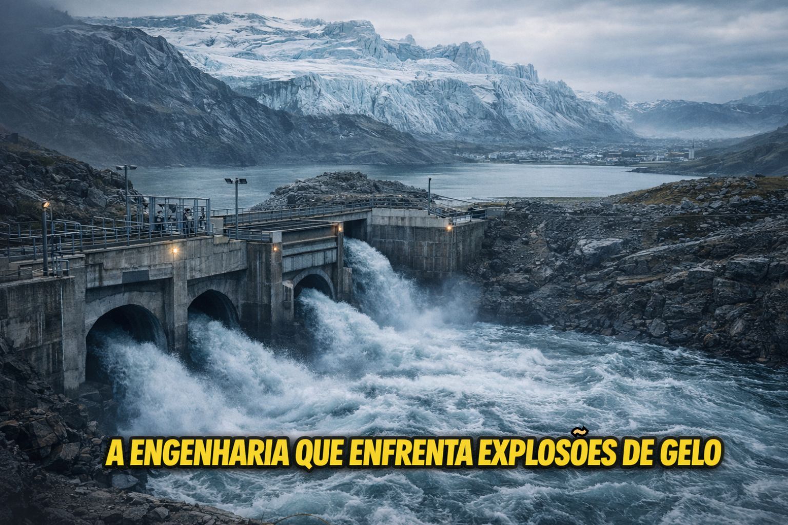
Iceland Digs Kilometers of Tunnels to Divert Explosive Glacial Flows Above 100,000 m³/s and Protect Coastal Cities from Catastrophic Flooding.
Few places on the planet interact with nature as directly and unpredictably as Iceland. In addition to volcanoes, lava, geysers, and tectonic plates that grind beneath their feet, there is a lesser-known and extremely dangerous phenomenon: the jökulhlaup, an Icelandic term that describes sudden subglacial flooding capable of releasing volumes of water impossible to contain with conventional dams.
These floods are not the result of rain, storms, or gradual thawing: they occur when subglacial lakes trapped under the ice are heated by volcanoes or by the very friction of the glaciers. When internal pressure breaks a fragile point, the result can be a land tsunami of water, sediments, and ice blocks rushing down entire valleys to the sea.
The Phenomenon That Shaped Cities, Roads, and Bridges
The jökulhlaups have been documented numerous times over the last centuries. One of the most well-known occurred in 1996 when an eruption under the Vatnajökull glacier triggered a jökulhlaup with a maximum estimated flow rate above 50,000 m³/s, destroying roads, bridges, and freshly formed lava fields. For comparison, this is more than double the maximum flow rate of the Amazon River in sections close to the mouth.
-
Finer than a human hair and 200 times stronger than steel, graphene is moving out of laboratories and into construction sites, potentially creating buildings that bend without breaking, reduce carbon emissions by half, and are 3D printed like Lego pieces.

-
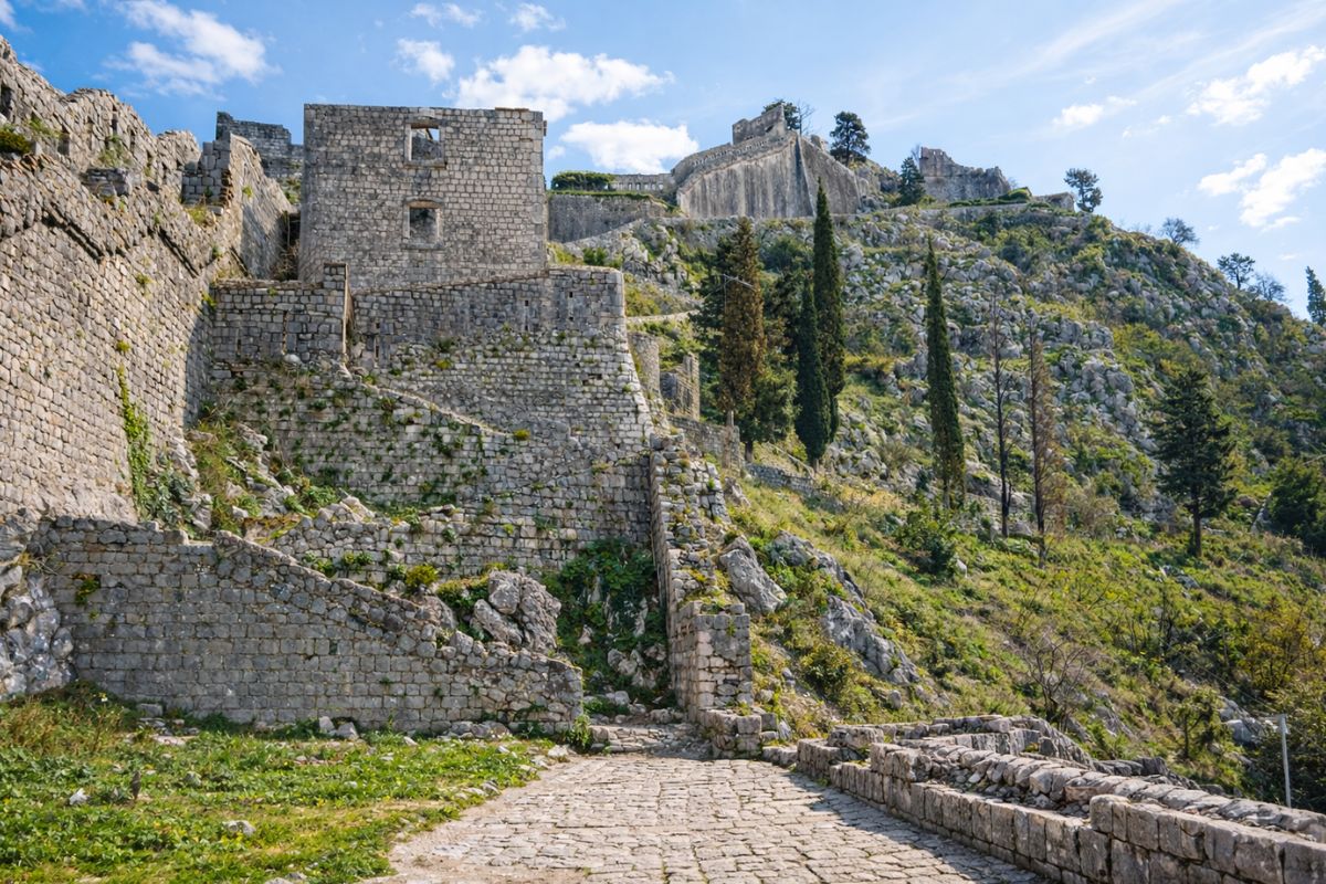
Kotor, Montenegro, reveals a medieval defensive system with 5 km of Venetian walls, gates with a drawbridge, and a fortress on Mount San Giovanni accessed by 1,000 steps, dominating the Bay as a strategic outpost.
-
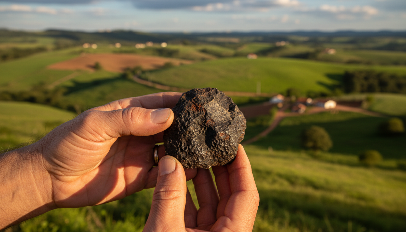
Stored for nearly 70 years in the backyard of a family in the interior of Minas Gerais, a fragment of a meteorite that fell in 1956 was divided at the Smithsonian Institution in the United States, and only now is the complete story of the fall being revealed.
-
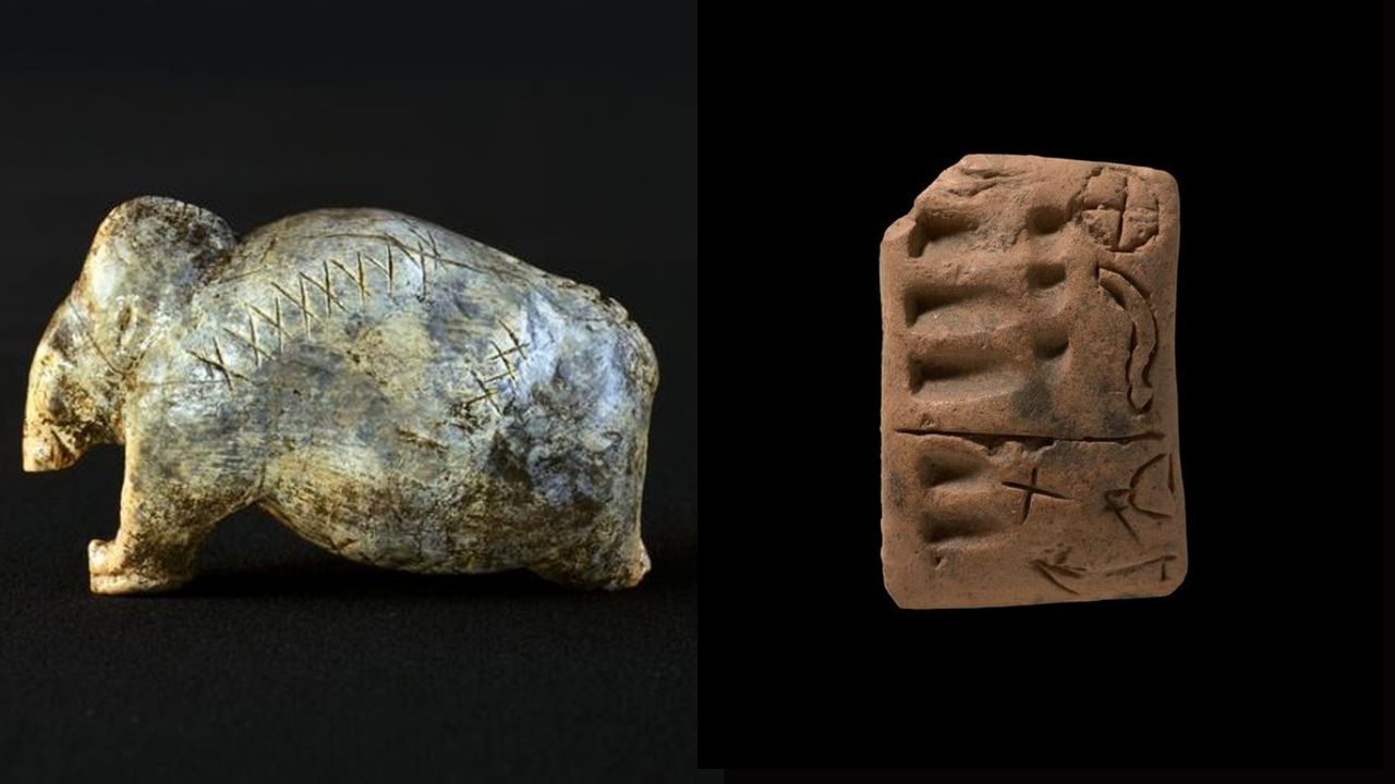
Findings of up to 40,000 years in caves in Germany display carved signs with a pattern comparable to proto-writing, which may reveal one of the oldest precursors of written language and compel scientists to reopen the history of when humans began to transform symbols into information.
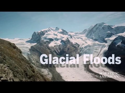
In other events, models and geological reports indicate peaks above 100,000 m³/s, values that rank among the largest water flows ever measured outside of ocean megatsunamis. This kind of violent discharge not only sweeps away vehicles and infrastructure but also carries tons of basaltic sediments that bury entire valleys.
The issue has ceased to be a rare phenomenon and has become a national infrastructure problem: circular highways, agricultural areas, coastal cities, and hydropower plants are in the path of these floods of liquid ice.
The Icelandic Response: Subterranean Engineering to Divert Invisible Rivers
How to contain something that cannot be dammed, that emerges from beneath glaciers, and that is only detected when the event is already underway? Not with dams, but with tunnels and relief channels excavated directly into the volcanic rock.
These systems—technically known as jökulhlaup diversion systems—have been designed to serve two simultaneous functions:
- Reduce pressure in subglacial lakes before natural rupture occurs;
- Divert the violent flow to less populated valleys or directly to the sea.
The solution involves dozens of kilometers of tunnels, galleries, and underground pipelines that function as giant geological drains, connecting subglacial chambers to the ocean or dissipation basins.
How an Anti-Jökulhlaup Tunnel Works in Practice
The process begins with drilling a drainage gallery from the ground to the base of the glacier. Water is kept under control and the ice acts as a structural ceiling. When the subglacial lake heats up and increases in volume, instead of randomly breaking through the glacier, it flows down the tunnel under controlled pressure.
The tunnels are designed to withstand volumes that can grow exponentially. In certain sections, they use refractory concrete-lined sections and hydraulic gates to control flows and prevent backflows. There is also a monitoring component that includes:
- Subglacial pressure sensors
- Seismographs
- Thermal conductivity sensors
- Ground Penetrating Radar (GPR)
With this data, engineers and geophysicists can predict hours or days in advance when a jökulhlaup is about to occur, activating diversions and notifying authorities.
Protection of Coastal Cities and National Infrastructure
The main objective of these tunnels is not only to save lives but also to preserve critical infrastructure, including:
- Sections of the Ring Road—the highway that circles Iceland
- Bridges over glacial rivers
- Electrical substations
- Hydropower plants
- Small coastal villages
- Industrial fish processing plants
- Agricultural reserves
A bridge destroyed by a jökulhlaup can isolate entire regions for weeks, hampering tourism, logistics, fish export, and internal energy transport. The engineering that controls the jökulhlaup is therefore economic, geological, and civil.

The Role of Accelerated Melting and Active Volcanism
The problem has gained another layer with the advancement of climate change. The accelerated melting of glaciers increases volumes of subglacial water and raises the frequency of the phenomenon. At the same time, Icelandic volcanism remains active, providing heat to fuel the cycle.
This has caused Iceland to stop treating jökulhlaup as a rare event and start viewing it as a recurring and manageable phenomenon, integrating it into national infrastructure protocols. Among the sectors that depend on this control are:
- Tourism (roads and access to glacial parks)
- Energy (hydropower and geothermal)
- Road transport
- Coastal agriculture
- Industrial fishing
Engineering Against a Phenomenon That Exterminated Civilizations in the Past
Glaciological research indicates that similar drainage events have occurred throughout history on various continents, including northern Europe and North America, where post-glacial jökulhaups have completely redrawn watersheds.
The difference is that in Iceland, the phenomenon is still active, and the modern response shows something very rare: geology and engineering working together to tackle a process that has already destroyed entire cities in past eras.
A Living Geological Laboratory
Today, the country is considered a living laboratory for geophysicists, hydrologists, and civil engineers who investigate the impact of subglacial lakes in polar regions. With the acceleration of melting in Greenland and Antarctica, Icelandic knowledge is being closely observed by:
- Norway (Svalbard)
- Canada (Northwest Territories)
- Chile (Patagonian Ice Field)
- Russia (Kamchatka)
- USA (Alaska)
Tunnel technology can be exported as a concept to regions that will, for the first time, face jökulhlaups modern.
Iceland has chosen to confront a millennia-old geological enemy with an approach that few countries have even needed to imagine: digging tunnels to drain invisible rivers running beneath erupting glaciers. With dozens of kilometers of galleries and constant monitoring, Icelandic engineering has transformed what was once a disaster into a predictable, divertible, and controllable phenomenon.
It is a rare case where civil infrastructure not only keeps up with the climate but anticipates it, and where geology—often seen as a threat—becomes a fundamental element in the planning of an entire country.


-

-

2 pessoas reagiram a isso.