 Portuguese
  English
  Spanish
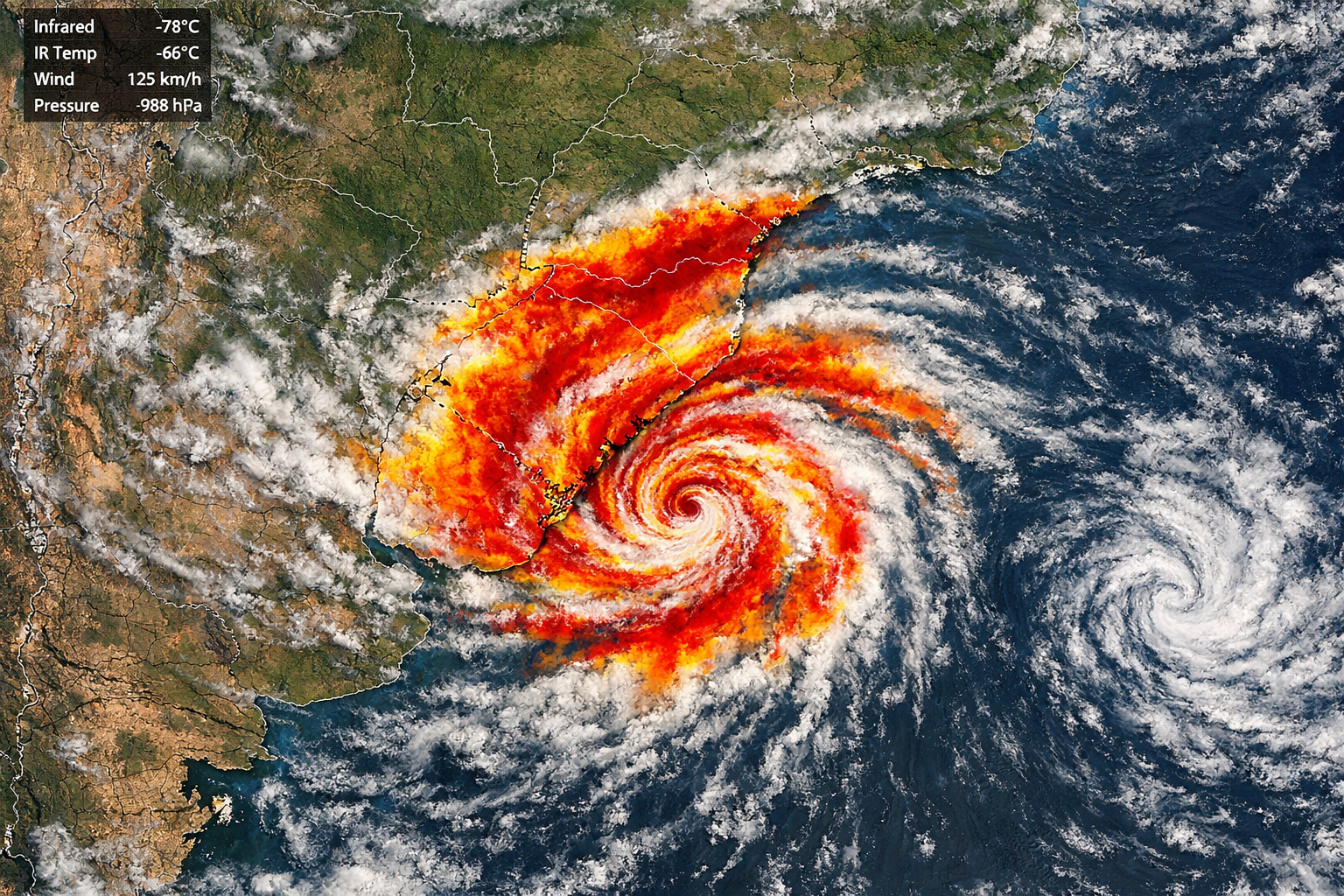
Intense atmospheric phenomenon completely changes the climatic scenario and puts several regions on alert with a forecast of rain throughout the day, as well as variations in the sky and the possibility of thunderstorms in different cities
Thursday (16) begins with a scenario of significant change in weather conditions in the South of Brazil. This information was released by MetSul Meteorologia, which monitors the formation of an atmospheric system that promises to completely alter the climate throughout the day.
This is a process known as cyclogenesis, which is underway between Argentina, Uruguay, and the South of Brazil. This phenomenon gives rise to an extratropical cyclone, responsible for causing instability, increased cloudiness, and large-scale rainfall episodes.
How cyclogenesis is impacting the south of Brazil and rapidly changing the weather

According to meteorological data, the extratropical cyclone is moving southeastward this Thursday (16), starting from the northeast of Argentina towards Uruguayan territory. Early in the day, the system will already be positioned in western Uruguay, advancing towards the east of the country by the end of the day.
-
Q-Day is coming: the quantum threat that can unlock passwords, banks, cryptocurrencies, medical data, and turn internet security upside down

-
Denmark deploys four 10-meter robot ships to monitor the Baltic Sea, protect submarine cables, and track invisible threats following explosions, sabotage, and rising tensions with Russia.

-
Textron Systems presents the Ripsaw M1, a nearly 2-ton military ground robot designed to fight alongside US Marines, hunt drones, launch munitions, and keep soldiers out of the line of fire.
-
Forget regular asphalt: USA, France, Germany, and Switzerland are starting to test highways with armored solar panels capable of supporting heavy trucks, generating electricity for entire neighborhoods, and transforming 1 km of road into an intelligent solar power plant.


As a direct consequence of this movement, instability decreases in northeastern Argentina after days marked by heavy rain and storms. However, conversely, it intensifies in Uruguay, northern Buenos Aires province, and also in Rio Grande do Sul, creating a scenario of concern for residents of these regions.
Moreover, the advance of this atmospheric system reinforces the change in the climatic pattern, bringing a day with characteristics typical of widespread instability.
Detailed forecast indicates rain since the early morning and advancement of instability throughout the day
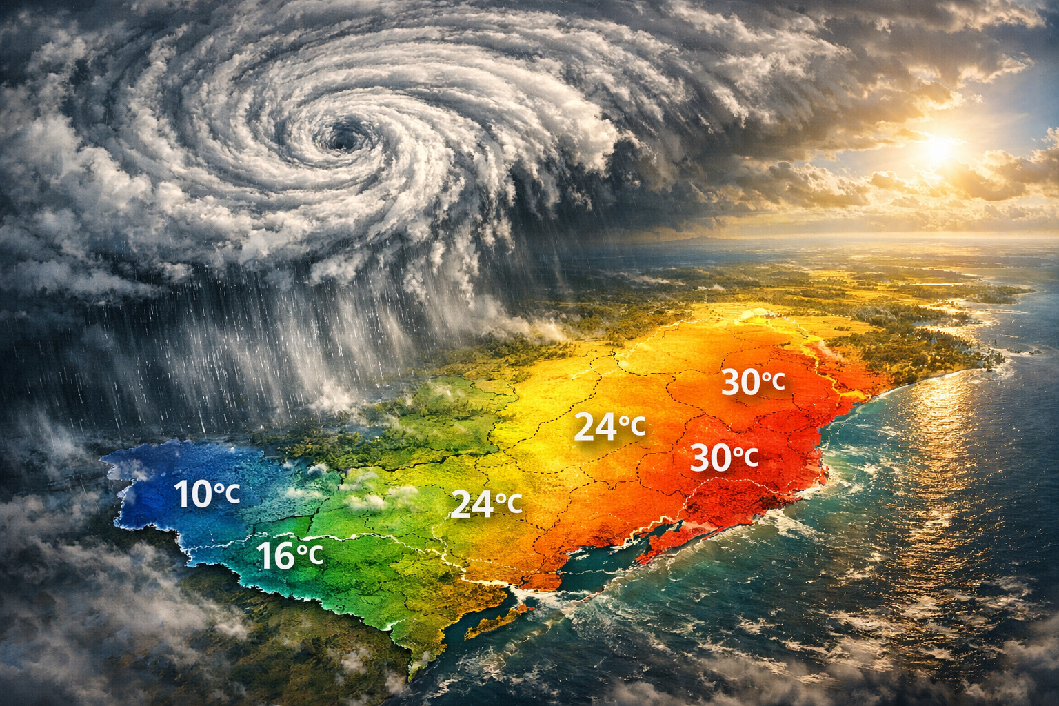
In the gaucho territory, the forecast indicates a day marked by abundant cloudiness and rain distributed throughout the day. In fact, there are already reports of precipitation since the early morning and during the morning in most of the state.
At the same time, instability moves from west to east, which favors the occurrence of thunderstorms in some cities. Thus, by the end of Thursday, all regions of Rio Grande do Sul should register rain at some point.
Despite this, precipitation volumes are not expected to be extremely high in most municipalities. This happens because the intensity of instability tends to be lower compared to neighboring areas, such as Argentina and Uruguay. Still, moderate to heavy rain in isolated spots cannot be ruled out.
On the other hand, even with the predominance of clouds and instability, breaks in the weather may occur throughout the day. This behavior is explained by the rotation of the low-pressure area and the infiltration of dry air in northern Argentina, which may allow for moments of improvement, especially during the afternoon.
Friday will have a different scenario with sunshine and irregular rain in some areas
On Friday, the scenario begins to change again. With the extratropical cyclone positioned off the coast of Uruguay, the sun returns to appear accompanied by clouds in various regions of Rio Grande do Sul.
However, despite the partial improvement, periods of greater cloudiness are still expected throughout the day. In addition, there is a forecast of isolated rain or drizzle in different parts of the state, although in a quite irregular manner and with low volumes in most areas.
Another important factor is the wind, which is expected to gain intensity, especially in the Southern Coast, where gusts of moderate to strong winds are expected by the end of the day.


Be the first to react!