Portuguese
  Spanish
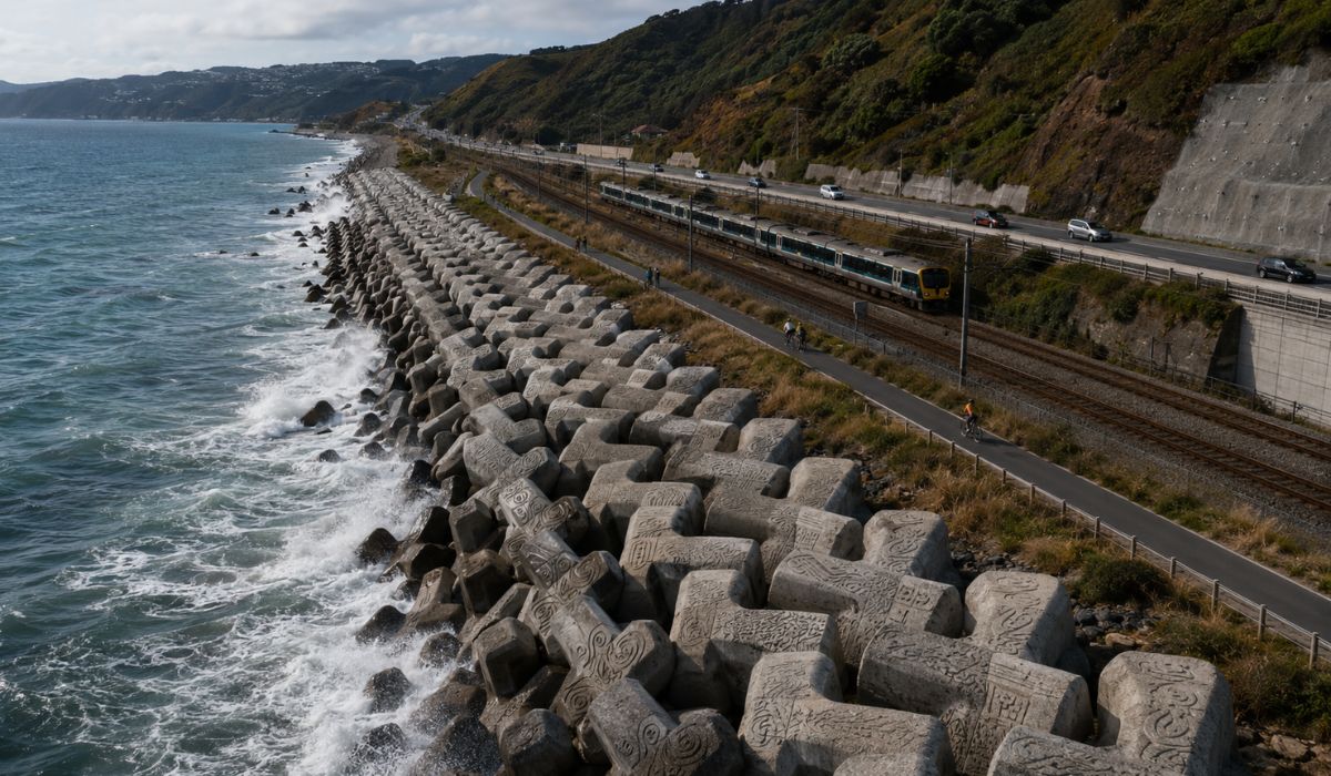
Coastal project in Wellington combines Dutch engineering, Māori design, and infrastructure protection in a route where highway, railway, and shared path share space with the sea.
New Zealand opened to the public, on May 16, 2026, a new section of Te Ara Tupua, a shared path for pedestrians and cyclists between Wellington and Lower Hutt.
The project includes a coastal barrier formed by thousands of X-shaped concrete blocks, interlocked like puzzle pieces to protect the shoreline, State Highway 2, and the Hutt Valley railway network from the impacts of the sea and extreme events.
The project is located on the Ngā Ūranga ki Pito-One section, a coastal strip used by part of the transportation infrastructure of the Wellington region.
-
Billionaire says the most valuable skill will help overcome job elimination caused by AI, following Bill Gates’ fears

-
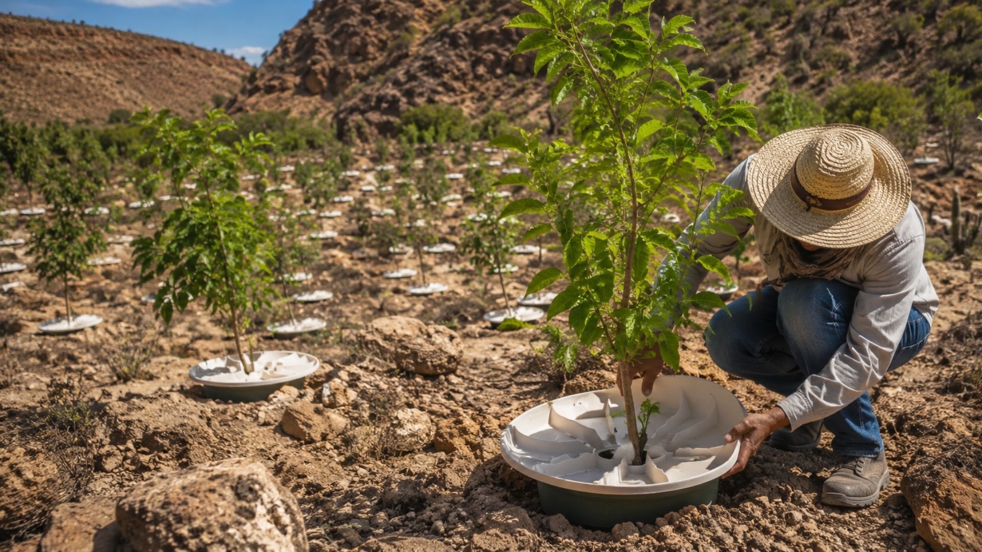
A Dutchman created a ‘box’ that makes trees grow in the desert almost without water and without irrigation: the invention has already brought seedlings to dozens of countries and achieves up to 90% survival where common planting did not exceed 10%.

-
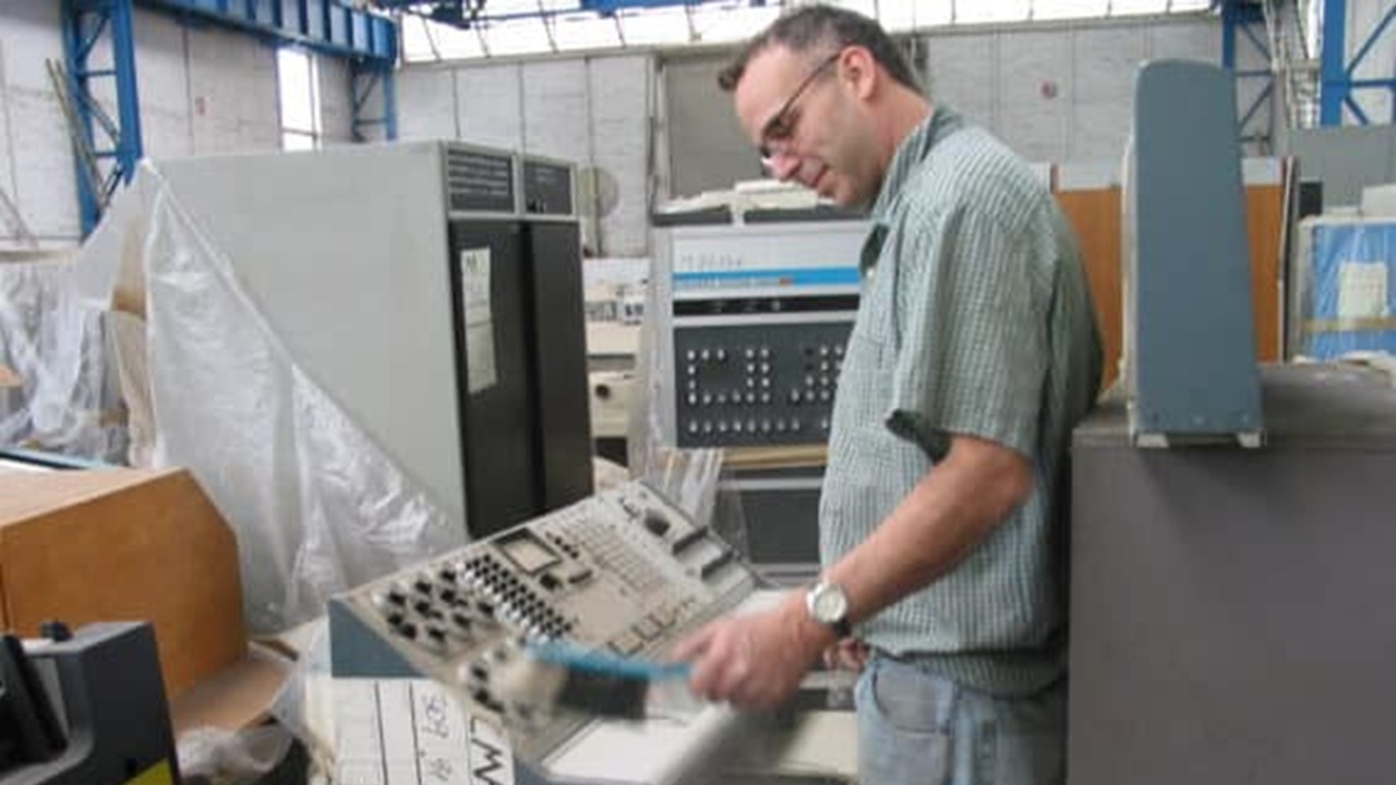
Abandoned warehouse hid a giant collection of rare computers, with over 2,000 artifacts from the 1930s to the 1980s.
-
Scientists warn that melting ice is triggering an alarming chemical transformation in preserved areas, and the first signs are already concerning researchers worldwide.


The site accommodates highway, railway, and now a route for walking and cycling.
According to the NZ Transport Agency Waka Kotahi, Te Ara Tupua was designed to enhance transport resilience, protect the railway line against storms, surges, and sea level rise, as well as improve the connection between Wellington and the Hutt Valley.
X-shaped blocks integrate coastal protection in Wellington
The structure installed at the waterline uses units called XBlocPlus, X-shaped concrete blocks that interlock and overlap to form a steeper maritime coating.
According to the NZTA, this shape reduces the area occupied by the barrier and decreases the volume of material needed compared to a coating made solely with rocks.
The Dutch Embassy in New Zealand reported that nearly 7,000 XBlocPlus units were installed along the Te Ara Tupua shoreline.
The technical page of Xbloc records 6,650 blocks of 1 cubic meter, distributed across eight structures and about 2 kilometers of coastal coating.
Therefore, the phrase “nearly 7,000” appears in the text as an approximation based on institutional disclosure.
The technology was developed by Delta Marine Consultants, a Dutch company that is part of Van Oord.
According to the representation of the Dutch government, the blocks were initially used in the Afsluitdijk project in the Netherlands and later applied in other coastal projects worldwide.
In the New Zealand case, the choice allowed for the construction of the protection at a steeper slope, saving material, space, and almost 12 months in the construction schedule, according to the same source.
Te Ara Tupua protects highway, railway, and cycleway
Te Ara Tupua is not limited to serving as a route for cyclists and pedestrians.
The coastal corridor between Wellington and Lower Hutt concentrates daily commutes and infrastructure considered strategic for the region.
The State Highway 2 and the Hutt Valley railway are close to the sea, in an area exposed to swells, storms, and risks associated with sea level rise.
In the announcement about the opening, New Zealand’s Minister of Transport, Chris Bishop, stated that the final stretch of the broader project will protect State Highway 2 and the Hutt Valley railway network from the impacts of severe weather, while also providing a safe connection for walking and cycling.
The government reported that the total cost of the Ngā Ūranga to Petone section is 348.7 million New Zealand dollars, with funding divided between the Crown, NZTA, Wellington City Council, and Greater Wellington Regional Council.
NZTA is leading the project in partnership with iwi mana whenua, including Taranaki Whānui and Ngāti Toa, as well as local councils of Wellington City, Greater Wellington, and Hutt City.
The Te Ara Tupua Alliance, responsible for the Ngā Ūranga ki Pito-One section, brings together the agency and the companies Tonkin + Taylor, Downer NZ, and HEB Construction.
Coastal barrier was tested for earthquakes
One of the technical aspects of the project is the adaptation of the barrier for seismic conditions.
NZTA states that Te Ara Tupua is the first project where the seismic performance of XBlocPlus units was considered and tested in the design of the structure.
This measure relates to the fact that the new seawall is built over a major active fault.
This aspect places the work in a category that combines coastal protection, urban mobility, climate adaptation, and geological risk.
Instead of treating the structure solely as a wave barrier, the project incorporated requirements related to the sea, transportation, and land instability.
In practice, the X-shaped blocks were designed to dissipate wave energy, help stabilize the coastal strip, and occupy less space than conventional alternatives.
This feature is relevant in the section because the cycleway, highway, and railway share a narrow area between the terrain and Wellington Harbor.
Māori design appears on the surface of the blocks
The appearance of the blocks was also incorporated into the project planning.
According to the embassy of the Netherlands, the design of the units was developed in collaboration between engineers and the iwi design leader Len Hetet.
The proposal was named Te Ripowai, referring to the movement of water and the idea of guardians of the coastline.
Hetet summarized the concept with the phrase: “If we look after the land, the water will reciprocate”.
In a free translation, the message states that by taking care of the land, the water responds in kind.
In the context of the project, the phrase was used to explain the integration between coastal protection and the Māori cultural values associated with the territory.
The blocks received textures to reproduce characteristics of a natural rocky coast.
According to the NZTA, engineers and ecologists worked with Len Hetet to combine cultural design and environmental enhancement, with surface patterns aimed at stimulating the growth of marine plants.
The Dutch embassy also reported that the texture seeks to favor the presence of vegetation and marine life.
Shared path unites active transport and coastal protection
The new route was presented by the New Zealand government as a mobility alternative for cyclists and pedestrians.
The Te Ara Tupua creates a continuous link between Wellington and Lower Hutt, expands active transport options, and adds public use to a stretch marked by the presence of road and rail infrastructure.
However, coastal protection was not separated from the circulation space.
The blocks remain visible along the waterfront and integrate into the landscape of the shared path.
Thus, the technical structure also appears to those passing by on foot or by bicycle, not limited to the function of containment.
For route users, the sequence of interlocking pieces may seem just part of the waterfront design.
For the region’s infrastructure, the barrier was planned to reduce the exposure of an essential transport strip to waves, erosion, storms, sea advancement, and earthquakes.