
 Portuguese
  Spanish
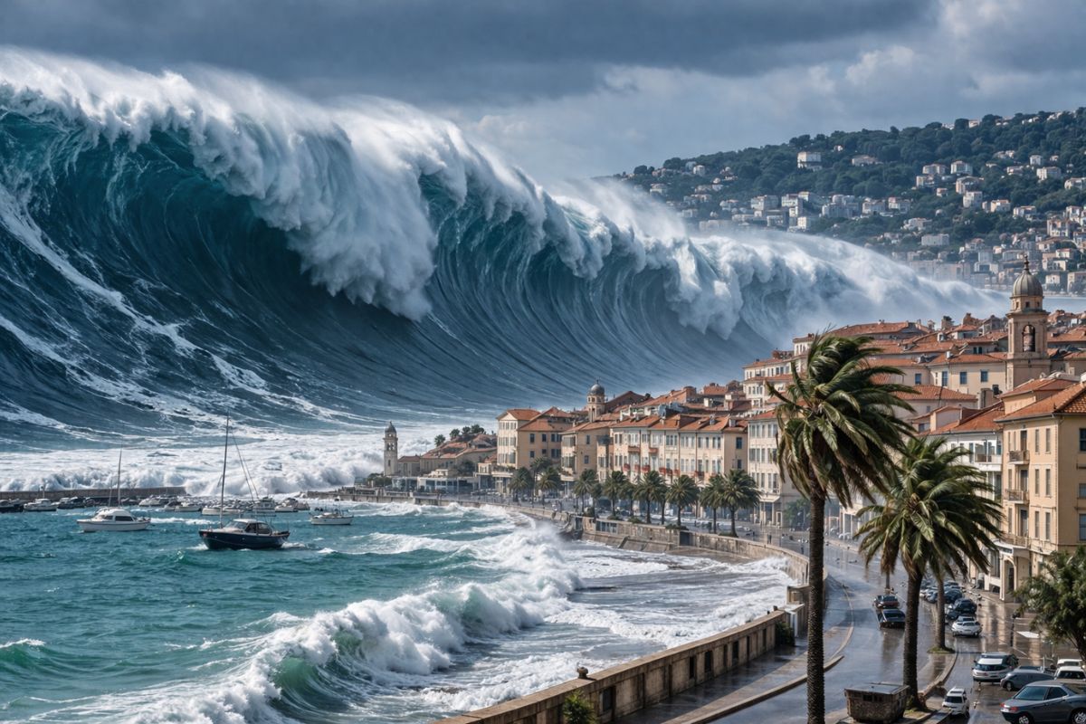
Scientific studies indicate that the probability of a tsunami hitting the southern coast of Europe in the next 30 years exceeds 90%, with active tectonic faults beneath the Mediterranean accumulating pressure, while millions of people live in coastal areas without protection barriers and UNESCO is working to train populations in evacuation routes.
The stability of the coastal zones of southern Europe faces a scenario that scientists describe as inevitable in terms of probability. Recent studies indicate that the chance of a tsunami hitting the Mediterranean region in the next 30 years already exceeds 90%, a number that transforms the question of “if it will happen” into “when it will happen.” The convergence of tectonic plates beneath the ocean floor creates accumulated pressure that can be released suddenly and devastatingly at various sensitive points, displacing massive volumes of water toward densely populated cities.
The silent movement of geological faults at the bottom of the Mediterranean represents a constant danger for millions of inhabitants living in low and unprotected areas. Continuous monitoring of these faults through underwater sensors and buoys is the only technical way to anticipate a tsunami with enough time for mass evacuations. The local geology is complex, with active faults spread across a region that includes the coasts of Italy, Greece, Turkey, Spain, and North Africa, all with the potential to generate waves that would reach the shore in minutes.
Why the probability of a tsunami in the Mediterranean is so high

The Mediterranean is a sea surrounded by colliding tectonic plates. The African plate is moving toward the Eurasian plate at a constant rate, and this convergence generates accumulated tension in underwater faults that can rupture at any moment, causing earthquakes on the seabed that displace entire columns of water toward the coast.
-
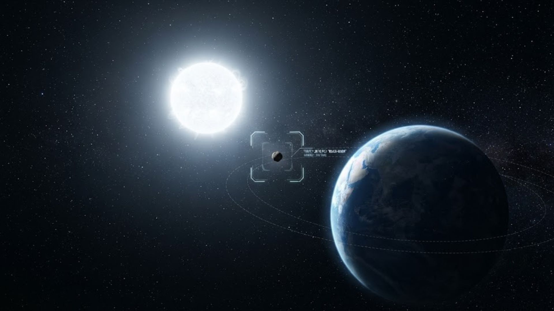
Few people know, but China photographed for the first time Earth’s “quasi-moon,” a small asteroid that accompanies our planet around the Sun and may be a fragment torn from the Moon millions of years ago.

-
China delivers a giant crane ship capable of lifting 2,200 tons at once, transporting structures of up to 10,000 tons, and operating in semi-submersible mode for offshore projects.
-
One of the most devastating El Niños in modern history did not only bring heat: amidst droughts, destroyed crops, and lack of supplies, 50 million people died across three continents, and scientists see in this past a brutal warning for a hotter planet.

-
EcoFlow’s Portable Fridge Offers 43 Hours Off-Grid, Reaches -25°C, App-Controlled, Solar-Powered for Camping and RV Adventures


Unlike the Pacific Ocean, where distances between the earthquake’s origin and the coast can be thousands of kilometers, in the Mediterranean the distances are short and the time between the generation of the tsunami and its impact on the coast can be as little as 15 to 30 minutes.
This proximity makes tsunamis in the Mediterranean especially dangerous because it drastically reduces the available evacuation time. In the Pacific, warning systems can provide hours of advance notice.
In the Mediterranean, the reaction window is measured in minutes, which requires coastal populations to be trained in advance and for warning systems to operate with a speed that allows no room for technical failures or bureaucratic delays.
The coastal areas most vulnerable to tsunamis in the Mediterranean
The high population density along the Mediterranean shores turns any natural event into a potential catastrophe of large proportions.
In addition to human lives, critical infrastructure for energy, sanitation, and transportation is often located in areas easily accessible to flooding, especially in tourist spots that economically depend on proximity to the sea and lack efficient natural barriers against large waves.
The specific topography of certain bays and gulfs can amplify the force of a tsunami, making the impact much more aggressive than initial models predict. When a wave enters a narrow gulf, the funneling compresses the water and exponentially increases its height.
Historic cities built with ancient architecture and unstable soil face an additional risk of severe structural damage. Urban planning in these regions needs to consider these geographical variables to establish escape routes and elevated safety zones.
How detection systems that can anticipate a tsunami work
Defense against a tsunami begins at the bottom of the sea. Pressure sensors installed on the ocean floor and monitoring buoys send real-time data to command centers that process the information and issue immediate alerts to civil protection authorities.
Technology allows every second to be utilized to activate sirens, halt traffic, and direct populations to elevated zones.
The preparation of local communities complements technology with rigorous training and clear signage of danger areas. Simulated exercises with the civilian population test the effectiveness of escape routes and identify bottlenecks that need to be corrected before a real tsunami occurs.
Constant maintenance of sirens and communication channels with signal redundancy ensures that alerts reach even when part of the infrastructure is compromised. Heat maps with priority flood zones are periodically updated to reflect changes in land use.
The role of UNESCO and international cooperation in tsunami prevention
UNESCO plays a central role in standardizing alert criteria and promoting technical cooperation among nations that share the Mediterranean. This integration allows data from tremors detected in a remote location to benefit the safety of all neighboring countries, creating a protective network that does not respect borders because tsunamis do not either.
UNESCO’s goal is to train 100% of coastal populations in risk areas so they know how to react.
International agreements fund the modernization of tide gauge stations in strategic locations, the creation of regional alert centers with continuous operation, and the development of predictive modeling software that simulates different tsunami scenarios for each stretch of coastline.
These tools allow local authorities to know exactly which areas would be flooded, to what depth, and in how much time, information that transforms generic plans into specific protocols for each community.
What can be done to protect cities before the tsunami arrives
The construction of physical barriers, such as artificial reefs, and the preservation of coastal vegetation are important steps to reduce the energy of the waters before they reach urban areas. Engineering works designed to withstand extreme pressures can protect the core of cities and vital facilities from damage that would paralyze the entire region.
Investment in resilient infrastructure preserves public heritage and ensures the continuity of basic services in the post-impact phase.
But the most effective barrier against a tsunami remains education. A well-informed and trained society is the most resilient component of any defense system, allowing for a coordinated and efficient response in the face of danger. The culture of prevention needs to be integrated into the daily lives of coastal cities so that preparedness is permanent.
When the tsunami arrives, and scientists say that the probability exceeds 90% in the next 30 years, the difference between tragedy and survival will be measured by what was done before, not after.
What do you think about living in a region where the probability of a tsunami in the next 30 years already exceeds 90%? Do you believe that current alert systems are sufficient or that there is a lack of preparedness? Share in the comments. Natural disasters that science has already predicted but that have not yet occurred generate an urgent debate between acting now or waiting for the worst to confirm the numbers.


