 Portuguese
  English
  Spanish
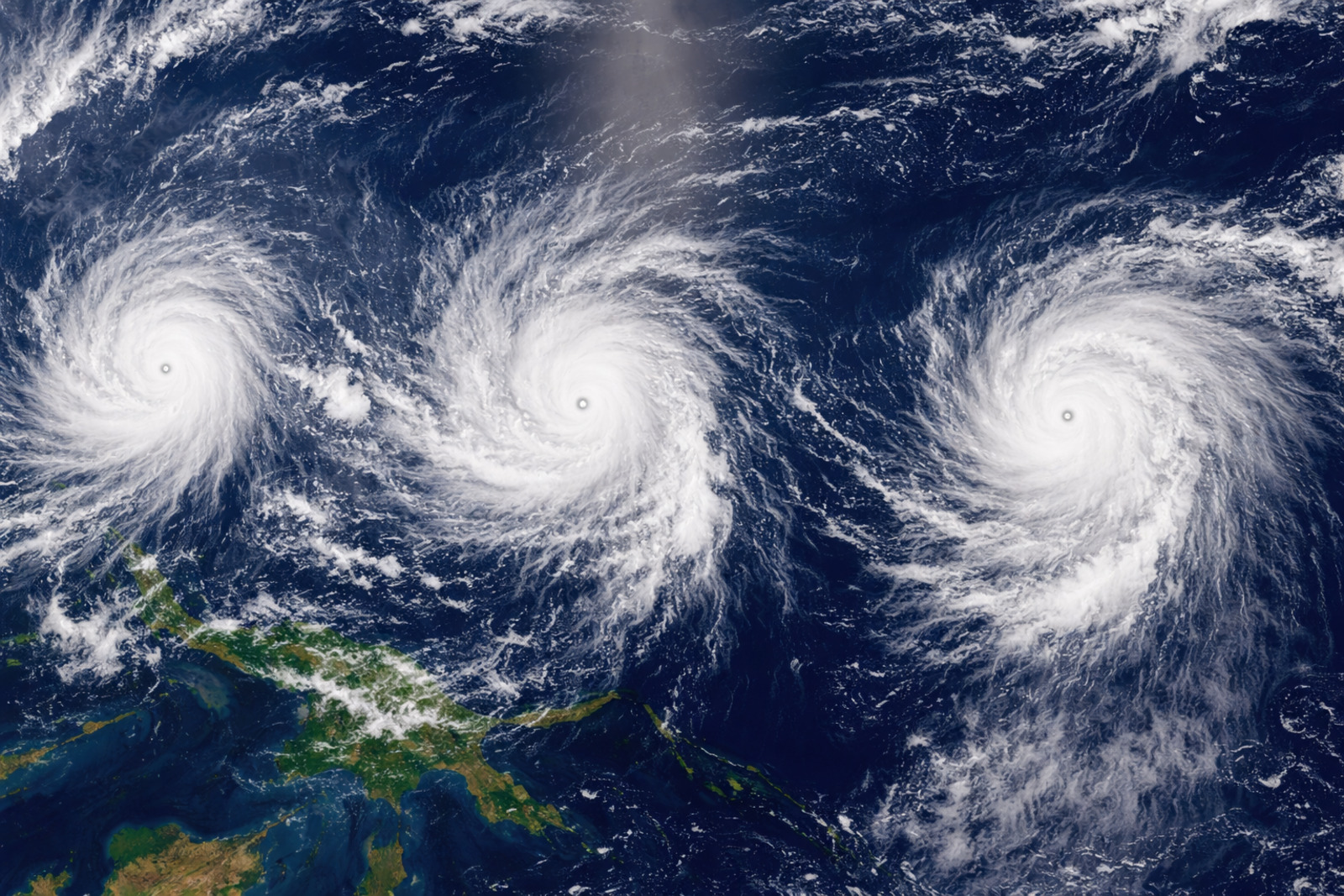
Twin and triple cyclones, rare events in the Pacific, can cause extreme rain, threaten islands, and intensify El Niño development
An alignment of storms may begin in the Western Pacific, with a risk of rain in island nations and the potential to increase the chances of a strong El Niño or super El Niño this year. The data comes from an article by The Washington Post.
Rare formation
Forecasts indicate that tropical cyclones may arise on opposite sides of the equator at the same time and at the same longitude, in a configuration known as twin cyclones.
There is also the likelihood of triple cyclones, with two systems south of the equator and one north. Twin cyclones occur every few years, while triples are rarer.
-
It seems simple, but it generates electricity: scientists transform ambient humidity into electricity with gelatin and salt, and the generator still works for more than 30 days.

-
Soon, smartphones may be able to “see” objects hidden behind walls with LiDAR.
-
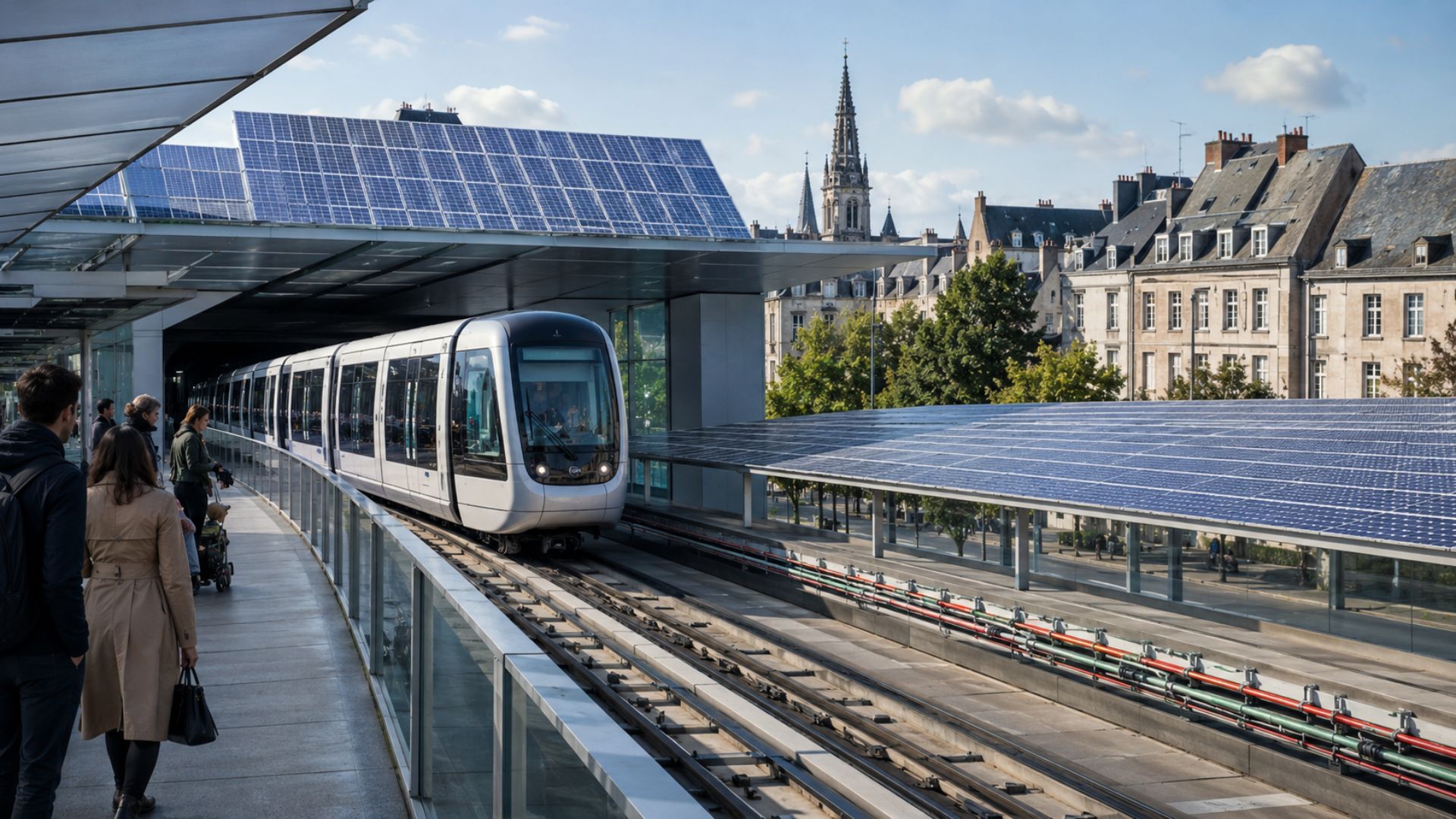
For the first time in France, solar electricity will power metro trains without going through the public grid. The pioneering Rennes project will begin construction in June with 6,000 square meters of solar panels, and users themselves can invest and earn a 5% annual profit.

-
United States releases a $2 billion investment in quantum computing with IBM’s participation, strengthening strategic technological infrastructure and accelerating the development of advanced processors that can change the internet, digital security, and global financial markets.


Areas at risk
One of the storms may form near the east of Papua New Guinea and the Solomon Islands. If it remains stationary next week, it could produce between 50 and 100 inches of rain or more.
The system is likely to develop in the Solomon Sea, an area where strong hurricanes are rare, but where water near 30°C can favor intensification.
Remote areas of eastern Papua New Guinea may suffer catastrophic flooding impacts. The country’s meteorological service has warned of the risk of flash floods and landslides.
This zone is part of a critical point in the Western Pacific, where increased flows of atmospheric moisture are associated with episodes of extreme rain.
A second storm is expected to form over the weekend and move between Vanuatu and Fiji, bringing rain, strong winds, and rough seas.
On the opposite side of the equator, a twin or triple storm may also slowly form in the northwest Pacific next week.
Micronesia, Guam, and the Northern Mariana Islands should monitor local forecasts.
Precedents and damage
The text cites Cyclone Hyacinthe, a world record holder for rainfall caused by a tropical cyclone. There were 223 inches, or 566 cm, on Réunion Island in 10 days in January 1980.
In November 2007, Cyclone Guba caused severe damage and deaths in southeastern Papua New Guinea, in an area not far from Port Moresby.
Another case occurred in March 2015, when a similar pattern preceded Cyclone Pam, one of the most powerful ever recorded in the South Pacific. The storm hit Vanuatu and caused destruction and fatalities.
Twin cyclones also occurred in the Pacific in March 2015 and in October 1997, during the formation of previous super El Niño events.
Relationship with El Niño
Eric Webb, a meteorologist at the Department of Defense, stated that these cyclones may increase the chances of a strong El Niño this year.
According to him, the storms would push warm water across the Pacific toward the area where El Niño conditions are monitored, altering the ocean and the atmosphere.
The strong winds from these systems would create another burst of west winds, a decisive element for the development of El Niño. Several record gusts have already occurred this year.
The warm water advancing east reinforces the Bjerknes feedback. More warming generates more storms, which produce more warm west winds and feed the process.
Broader effects of cyclones
A super El Niño tends to be stronger, more persistent, and more widespread than a typical episode. The pattern influences droughts, floods, sea ice, and extreme heat in various parts of the planet.
Among the cited effects are fewer hurricanes in the Atlantic this year, more storms in the Pacific, and a likely rise in global temperatures in 2026 or 2027 to record global levels.
They may also change the frequency and location of heat waves, torrential rains, and droughts. NOAA issued an El Niño alert this month, and ECMWF will release updated forecasts next week.
With information from The Washington Post.


Be the first to react!