Portuguese
  Spanish
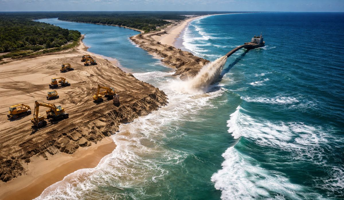
A break in the sandbar, emergency works, and the continuous force of the ocean place Bribie Island at the center of a story that mixes coastal dynamics, engineering, and environmental transformation in one of the most sensitive areas of the Australian coast.
Bribie Island, coastal erosion, and emergency work
The recovery of a broken section in the north of Bribie Island, on the coast of Queensland, Australia, mobilized dredging and coastal engineering teams to restore the sandbar that separates the ocean from the estuarine system of Pumicestone Passage.
The so-called “second break” was caused by strong swells associated with the former tropical cyclone Alfred and was ultimately closed by pumping tons of sand, which reconnected the island’s natural barrier.
The intervention was treated by local authorities as an emergency measure to reduce the effects of direct wave and tide entry into more sheltered areas.
-
While playing video games in his room, a 13-year-old teenager was struck by a lightning bolt that entered the house, left a hole in the wall, passed through a metal piece of the desk, and made the boy scream, thinking he was going to die.

-
A metal detector led a prospector to a rock that resisted a saw, acid, drill, and sledgehammer; years later, scientists cut the block with diamond and discovered a 17 kg meteorite from the beginning of the Solar System.

-
Just one message on WhatsApp: Belém launches “Plante Aqui” and plants a tree for free at your doorstep within 15 days, with a goal of 5,000 seedlings by the end of 2026 in the capital of Pará.

-
The most ‘stingy’ millionaire in Canada? Bill Holland saved money to retire at 32, led the management company that now manages $140 billion, and still takes public transportation, in the same club as Warren Buffett and Elon Musk.


With the closure, the state government and regional representatives began to point to the recomposition of the barrier as a relevant step to contain erosion and reduce the exposure of vulnerable sections of the coast in Golden Beach and around Caloundra.
Bribie Island is part of a sensitive coastal system in southeast Queensland and has 34 kilometers in length.
In practice, the island functions as a sandy barrier between the Coral Sea and Pumicestone Passage, a channel that has undergone natural changes over time.
When there is an opening in this sandbar, water circulation changes and can alter the behavior of waves, tides, and sediment transport.
How the break occurred in Bribie Island
This process returned to the center of debate after the opening recorded in February 2025.
According to Jen Kettleton-Butler, a volunteer with the Pumicestone Passage Catchment Management Board, the channel created in that episode widened to about 450 meters and began to pose a risk to low-lying areas of the region.
Commenting on the closure, she stated that the opening initiated at the end of February increased the incidence of higher tides and the energy of ocean waves on previously less exposed sections of the shore.
The problem did not start in 2025.
The northern portion of the island had already been monitored by public agencies and local entities since before the break caused in January 2022, during the effects of the former tropical cyclone Seth.
Since then, the area has focused on works, studies, and technical assessments regarding coastal erosion, changes in the channel, and impacts on navigation and the ecosystems associated with the Pumicestone Passage.
Documents from the Queensland government classify the region as a dynamic coastal system.
This means that the shape of the island, the position of sandbanks, and the width of the barrier can change with the combined action of tides, waves, winds, and storms.
In this context, the closure of the new opening was not presented as a definitive solution, but as an emergency response to stabilize the section and reduce immediate risks.
AU$ 20 million package and sand pumping
The work was part of an emergency package of 20 million Australian dollars announced by the state government in September 2025.
The execution was the responsibility of Hall Contracting, a company specialized in coastal dredging.
More than 250,000 cubic meters of sand were pumped to fill the breaches and reinforce the most fragile section of the northern tip of the island.
During the operation, about 20 workers operated on a continuous schedule.
The material removed by dredging was directed to restore the connection between the separated portions of the sand barrier.
In addition to closing the most recent opening, the project also included reinforcement of the section between the breaches associated with the former cyclones Alfred and Seth.
According to Kettleton-Butler, the structure being formed between the two points should reach 80 to 100 meters in width and be about 3 meters above the highest tide level.
This description was used by her to indicate that the new section would have dimensions greater than those observed in that area in recent decades.
The assessment was made by the volunteer while commenting on the scope of the work after the closure of the most recent channel.
Coastal protection in Golden Beach and Caloundra
Local authorities also related the intervention to preparation for the cyclone season.
The commander of the Caloundra Coast Guard, Roger Pearce, stated that the restoration of the sand strip would provide residents with an additional layer of protection against the energy of the open ocean.
According to him, the restored section should increase from about 50 meters to something close to 90 meters as the pumping progresses northward.
Pearce also informed that other phases of the work would be carried out in nearby areas considered narrow or susceptible to overflow during higher tides.
Among the points mentioned by him are Factory Gutter, a stretch where there are episodes of “washover” at high tide, and sectors near Bribie Bar and the so-called mini-bar, used as a reference for local navigation.
The intervention gained political and community weight because the Pumicestone Passage is treated in the region as an important waterway for circulation, fishing, recreation, and environmental balance.
Commenting on the progress of the work, state representative Kendall Morton stated that the closure of the breach represented a milestone in an old problem for Caloundra.
According to her, the reconstruction of the island helps protect the waterway that cuts through the region.
Environmental Impacts and Dynamics of the Pumicestone Passage
From a technical standpoint, official reports indicate that the opening in 2022 had already altered the local coastal dynamics.
Among the monitored effects were the increased penetration of waves and storm tide within the Pumicestone Passage, erosion at Golden Beach, and loss of seagrass areas due to sediment remobilization.
These studies helped support the emergency response adopted after the new breach in 2025.
Public documents also indicate that changes of this type do not only affect the visible coastline.
The redistribution of sand can interfere with water turbidity, the stability of sandbanks, circulation within the channel, and the habitat conditions for species linked to the estuary.
Therefore, monitoring of the region began to involve not only the physical evolution of the barrier but also environmental and operational indicators.
In the specific case of Pumicestone Passage, analyses from the Queensland Department of Environment and Science recorded that, after the first breach, water quality in the northern sector did not show immediate substantial change.
Still, the government maintained technical monitoring due to changes in water circulation and sediment behavior, considered relevant factors for the ecological health of the area.
Works on Bribie Island Continue in Phases
The closure of the second breach was treated as a phase within a broader set of interventions.
Official material from the Queensland government states that, after the installation of the construction site in August and the start of dredging at the end of September 2025, breach no. 2 was closed on November 13 and no. 3 on November 28.
Subsequently, teams continued with stabilization and channel deepening works.
The sequence shows that the project was not limited to covering a single point opened by the sea.
The public action focused on different sections of the extreme north of the island, where erosion had been recorded for years.
The strategy adopted by the government aimed to reduce the immediate vulnerability of the coast while studies on long-term management continue to be discussed in the state.
Barrier island, sand, and coastal transformation
In scientific terms, the case of Bribie Island is cited in environmental reports as an example of how barrier islands respond to extreme events and the natural dynamics of the coast.
In such areas, sand does not function merely as a beach covering.
The width, height, and position of this material influence how wave energy reaches the interior of channels and protected zones.
This characteristic explains why sand replenishment projects are often accompanied by assessments of erosion, flooding, ecosystems, and navigation.
In Bribie, the declared objective of the intervention was to restore, even if in an emergency manner, the natural barrier function of the island in a section that had been losing resistance since 2022.
The continuity of this role, according to official documents, depends on ongoing planning and monitoring.